Barren Island, situated approximately 135 kilometers northeast of Port Blair in the Andaman Sea, is India’s only active volcano and the only confirmed active volcano in South Asia. The geological formation lies within a seismically volatile zone where the Indian Plate subducts beneath the Burmese Plate, forming a major volcanic arc that extends into Southeast Asia. Following nearly two centuries of dormancy, the volcano reawakened in 1991 and has since erupted multiple times. Marine scientists and space agencies continuously monitor its ongoing volcanic activity using satellite telemetry and oceanographic expeditions. The remote, uninhabited island features a unique terrestrial ecosystem and rich marine biodiversity along its submerged volcanic slopes.
Tectonic Setting and Geographical Profile
Plate Tectonics and Volcanic Arc
The volcano is a critical component of the Andaman-Nicobar volcanic arc. This arc marks the convergent boundary where the Indian Plate subducts beneath the Burmese Microplate (a segment of the Eurasian Plate) at the Sunda Trench.
- Subduction Dynamics: As the oceanic crust of the Indian Plate sinks into the mantle, partial melting of the overriding plate generates magma. This magma ascends to the surface, fueling the volcanic systems of the region.
- Geographical Coordination: The island belongs to the Andaman and Nicobar Union Territory. It stands inside the deep waters of the Andaman Sea, structurally connected to the larger Sunda Arc system that runs through Indonesia.
Physical Geomorphology
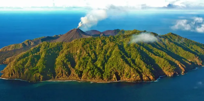
- Structure: Barren Island is a stratovolcano composed of alternating layers of hardened lava, tephra, pumice, and volcanic ash.
- Caldera Dimensions: The island is roughly 3 kilometers in diameter, featuring a large caldera that spans nearly 2 kilometers. This caldera wall was breached during ancient explosive phases, opening a channel toward the western coast.
- Elevation: The highest peak of the volcanic cone rises to an elevation of approximately 354 meters above sea level, though the vast majority of the volcanic mountain remains submerged.
Historical Eruptions and Monitoring
Eruptive Timeline
- Pre-1991 Dormancy: The volcano experienced a recorded eruption in 1787, followed by minor activity in the early 19th century. It then entered a prolonged dormant phase lasting nearly 200 years.
- The 1991 Reawakening: A major explosive eruption occurred in 1991, destroying the island’s limited vegetation and altering the shape of the central vent.
- Subsequent Eruptive Cycles: The volcano entered active phases again in 1994–95, 2005–07, and has shown intermittent Strombolian eruptions, ash emissions, and lava flows into the 2020s.
Surveillance Infrastructure
| Monitoring Entity | Methodology | Key Observations |
| Indian Space Research Organisation (ISRO) | INSAT & Resourcesat thermal sensors | Detection of thermal anomalies and hotspots inside the crater. |
| Geological Survey of India (GSI) | Field expeditions & ocean cruises | Collection of fresh lava samples, ash analysis, and bathymetric mapping. |
| National Institute of Oceanography (NIO) | Research vessels (e.g., RV Sindhu Sankalp) | Sub-surface seismic monitoring and hydrothermal vent detection. |
Ecology and Conservation Status
Terrestrial and Marine Biodiversity
Despite its harsh environment, the island hosts a resilient ecosystem.
- Fauna: The island is largely uninhabited by humans. It supports small populations of feral goats, fruit bats, and specialized avian species that survive near the edges of the caldera.
- Marine Habitat: The waters surrounding Barren Island are renowned for crystal-clear visibility, massive coral reefs, and volcanic basalt formations. Manta rays, reef sharks, and diverse pelagic fish thrive along the underwater drop-offs.
Administrative Restrictions
The inner perimeter of the island is strictly restricted. Visitors require special permits from the Andaman and Nicobar Administration. Landing on the shore is generally prohibited due to the unpredictable nature of gas emissions and sudden explosive activity.
IASPOINT Booster Facts for UPSC
- Narcondam Island: Located roughly 140 kilometers north of Barren Island, Narcondam is another volcanic island belonging to India. However, it is classified as an extinct or dormant volcano.
- Strombolian Eruptions: The typical eruptive style of Barren Island involves low-energy, episodic explosions that eject incandescent cinder, lapilli, and lava bombs, resembling the classic activity of Italy’s Stromboli volcano.
- Sunda Arc Connection: The volcanic line starting from Myanmar’s Mount Popa passes through Barren Island and Narcondam Island before merging into the highly active Indonesian volcanic chain containing Krakatoa and Mount Tambora.
- Geothermal Potential: Scientists have recorded high thermal signatures and underwater hot springs around Barren Island, indicating significant untapped geothermal energy potential in the Andaman Sea seabed.