The Pennar River, historically called the Peenigula Penna due to its dry and barren state, recently registered an unusual water flow in the Kalyanadurg area of Anantapur district ahead of the Southwest monsoon. This rare hydrological event has raised agricultural expectations among local farmers in the drought-prone Rayalaseema region of Andhra Pradesh. Originating in the Nandi Hills of Karnataka, the non-perennial river traverses arid and semi-arid landscapes before emptying into the Bay of Bengal. Concurrently, the historic 12th-century Dharmavaram Cheruvu reservoir is approaching its maximum capacity for the first time in several decades due to these elevated early inflows.
Geographical and Hydrological Profile
The Pennar River basin constitutes a vital hydrological unit within the southern Deccan Plateau, covering an area of 55,213 square kilometers across Karnataka and Andhra Pradesh.
Origin and Course
- Source: The river originates at Chennakasava Hill within the Nandi Hills range in the Chikkaballapura district of Karnataka.
- Length: It flows for a total distance of 597 kilometers.
- Drainage Basin Boundaries: The basin is bounded by the Erramala hills to the north, the Nallamala and Velikonda ranges of the Eastern Ghats to the east, and the Nandidurg hills to the south. The Kolar Plateau forms the watershed divide separating it from the Kaveri, Ponnaiyar, and Palar basins.
- Termination: It flows east through a structural gap in the Eastern Ghats and discharges into the Bay of Bengal near Uttukuru, located 15 kilometers east of Nellore.
Tributary Network
The river network consists entirely of seasonal streams that rely on monsoonal precipitation.
| Left Bank Tributaries | Right Bank Tributaries |
| Jayamangali | Chitravati |
| Kunderu | Papagni |
| Sagileru | Cheyyeru |
Irrigation Infrastructure and Water Management
The high variability in the river’s flow necessitates extensive storage structures to manage water resources for the dry Rayalaseema region.
Key Engineering Projects
- Somasila Dam: Located near Somasila village in the Nellore district, this is the largest reservoir built across the Pennar River. It regulates water storage and stabilizes downstream irrigation deltas.
- Gandikota Project: Situated within the Kadapa district, this reservoir captures flows near the famous Gandikota gorge, known as the Grand Canyon of India.
- Mylavaram Dam: Constructed across the main river channel in Kadapa district to supply irrigation canal systems.
- Chitravati Balancing Reservoir: Positioned on the right-bank tributary to secure water availability for drought-prone agricultural pockets.
Inter-Basin Water Transfer
Because the internal yield of the basin is fully utilized, water security depends heavily on imports from the adjacent Krishna River basin. Water is drawn from the Tungabhadra Dam through the High-Level Canal system to feed the upper reaches of the Pennar basin. Lower elevations receive water routed from the Srisailam Dam to bridge seasonal deficits.
Historical Hydraulics: Dharmavaram Cheruvu
The current filling of the Dharmavaram Cheruvu reflects the longevity of medieval South Indian water harvesting systems. Built during the 12th century under the patronage of regional rulers, this tank system belongs to an interconnected cascade design typical of semi-arid Rayalaseema. It uses the natural topography to collect seasonal runoff from small streams, replenishing local groundwater levels and providing an assured source of water for gravity-fed irrigation canals.
IASPOINT Booster Facts for UPSC
- Alternative Nomenclature: The Pennar River is also known as the Uttara Pinakini. The term ‘Pinakini’ is derived from ‘Pinaka’, the mythical bow of Lord Shiva.
- The Dual Stream Phenomenon: The Nandi Hills serve as a unique hydro-geological node where two distinct rivers begin; the Northern Pennar (Uttara Pinakini) flows north-east, while the Southern Pennar (Dakshina Pinakini or Ponnaiyar) flows south.
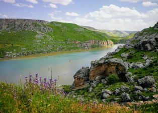
- Gorge Formation: The river cuts through the Erramala hills to form the Gandikota Gorge, exposing spectacular deep pink sandstone formations that reveal the evolutionary history of the Kadapa sedimentary basin.
- 1892 Water Sharing Agreement: Interstate water distribution within this basin continues to find its roots in the historic colonial-era agreement executed in 1892 between the Mysore Kingdom and the Madras Presidency, now managed under the Inter-State River Water Disputes Act of 1956.
- Navigational Connectivity: The Buckingham Canal, a historic man-made waterway running parallel to the Coromandel Coast, cuts through the lower Pennar delta, linking it directly to the Chennai port infrastructure and the Krishna River delta.