The Pennar River, a non-perennial river in the southern Deccan Plateau, recently recorded an unusual water flow in the Kalyanadurg area (Anantapur, Andhra Pradesh) ahead of the Southwest monsoon. This event has led to the historic 12th-century Dharmavaram Cheruvu reservoir nearing its maximum capacity, providing a significant boost to the drought-prone Rayalaseema region.
Geographical and Hydrological Profile
- Origin: The river originates at Chennakasava Hill (Nandi Hills, Karnataka) and flows for 597 km before discharging into the Bay of Bengal near Nellore.
- Basin Boundaries: Bounded by the Erramala hills (north), Nallamala/Velikonda ranges (east), and Nandidurg hills (south). The Kolar Plateau acts as the watershed divide.
- Tributaries: Seasonal streams include Jayamangali, Kunderu, Sagileru (left bank) and Chitravati, Papagni, Cheyyeru (right bank).
- Water Management: The basin relies on inter-basin transfers, primarily from the Krishna River (via Tungabhadra and Srisailam dams), to offset seasonal deficits. Key structures include Somasila Dam (largest), Gandikota project, and Mylavaram Dam.
IASPOINT Booster Facts
- Nomenclature: Also known as Uttara Pinakini; ‘Pinaka’ refers to Lord Shiva’s bow.
- Dual Origin: The Nandi Hills originate both the Northern Pennar (flows NE) and the Southern Pennar (Ponnaiyar, flows south).
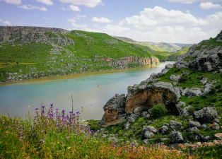
- Geological Landmark: The river forms the Gandikota Gorge (“Grand Canyon of India”) by cutting through Erramala hills.
- Governance: Interstate water sharing is managed under the Inter-State River Water Disputes Act, 1956, tracing back to an 1892 agreement.