India has deployed advanced geospatial technology for high-accuracy land and property mapping in the Union Territory of Chandigarh under the newly launched NAKSHA programme and the statutory provisions of the Punjab Abadi Deh (Record of Rights) Act, 2021. Serving as a critical pilot project, this technology-driven initiative focuses on surveying rural habitation areas, traditionally classified as abadi deh, alongside complex urban sectors. The intervention aims to resolve long-standing property ambiguities and update land management frameworks through the integration of drone imagery, field validation, and digital property records.
Operational Framework of NAKSHA and Legal Ecosystem
The NAKSHA (National Geospatial Knowledge-based Land Survey of Urban Habitations) programme operates as a targeted pilot under the Department of Land Resources, Ministry of Rural Development. It modernizes urban land records across selected locations nationwide.
Statutory and Institutional Architecture
- The Punjab Abadi Deh (Record of Rights) Act, 2021: This act provides the essential legal architecture to formalize and record property ownership rights within inhabited village lands (abadi deh) where structured land titles previously did not exist.
- Urban Property Cards: The data collated via the NAKSHA surveys feeds directly into the generation of institutional Urban Property Cards, providing legal proof of ownership to clear up title confusion.
- Institutional Coordination: The project runs as a collaborative effort involving the Department of Land Resources (DoLR), the Survey of India, the National Informatics Centre Services Inc. (NICSI), and designated national Centres of Excellence.
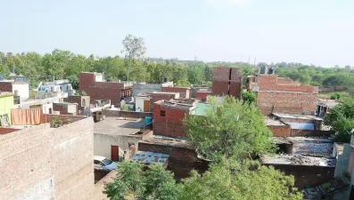
Technical Methodologies and Progress in Chandigarh
The pilot deployment in Chandigarh utilizes a multi-tiered technological approach to map geographic and structural assets with high precision.
Technological Matrix and Field Progress
- Drone Surveys: Since May 2025, systematic drone mapping operations have covered 5 villages (including Sarangpur, Kajheri, Burail, Attawa, and Palsora) and 15 urban sectors, spanning an aggregate area of 30.61 square kilometers.
- Target Population Benefit: The ongoing operations directly secure and digitize property details affecting a baseline population of nearly 148,000 residents.
- Ground-Truth Verification: Following initial drone data extraction, field survey teams use hand-held digital tools and Global Navigation Satellite System (GNSS) rovers to complete real-time physical verification and boundary dispute resolution.
- Three-Dimensional Mapping: In a parallel technological effort, the administration implemented a 3D mapping system using Light Detection and Ranging (LiDAR) technology to monitor spatial growth and detect illegal constructions.
Core Geospatial Technologies in Land Administration
Modern land reforms rely heavily on specific remote sensing and spatial data technologies to replace outdated chain-and-tape measurement systems.
Primary Mapping Technologies and Mechanisms
- Drone-based Photogrammetry: Low-altitude Unmanned Aerial Vehicles (UAVs) equipped with high-resolution 2D Nadir and multi-angle oblique cameras capture detailed imagery of dense, vertically stacked urban habitations.
- LiDAR (Light Detection and Ranging): An active remote sensing technology that emits laser pulses to measure precise distances to the Earth’s surface, creating highly accurate 3D point clouds of urban typography and building heights.
- Geographic Information Systems (GIS): Software environments used to store, layer, analyze, and display georeferenced land data, linking spatial coordinates directly to revenue ownership databases.
| Technology | Data Capture Mechanism | Core Application in Land Surveying |
| UAV / Drone Mapping | High-resolution aerial photography via nadir and oblique sensors | Rapid ortho-mosaic generation and physical boundary demarcation |
| LiDAR | Light/laser pulse reflection time measurements | 3D urban modeling, elevation tracking, and encroachment detection |
| GNSS / CORS | Satellite-based positioning linked to continuous reference stations | High-precision ground control points (GCP) and boundary fixing |
| Web-GIS | Cloud-based spatial data rendering and visualization | Centralized hosting of land records and public access to property maps |
IASPOINT Booster Facts for UPSC
- Digital India Land Records Modernization Programme (DILRMP): Launched originally as a Centrally Sponsored Scheme in 2008 (by merging CLR and SRA-LR), DILRMP is the umbrella initiative under which the NAKSHA programme is conceptualized to achieve a clean title governance system.
- SVAMITVA Scheme Linkage: While SVAMITVA (Survey of Villages Abadi and Mapping with Improvised Technology in Village Areas) targets rural abadi areas under the Ministry of Panchayati Raj, the NAKSHA programme specifically bridges the gap by targeting urban habitations and urban local bodies (ULBs).
- Legal Distinction of Abadi Deh: In traditional northern Indian revenue terminology, ‘Abadi Deh’ refers to the inhabited area of a village where houses are built, which historically stayed excluded from regular agricultural land surveys (Khasra mapping), leading to a lack of formal ownership documents.
- Seventh Schedule Allocation: Under the Constitution of India, ‘Land’ and ‘Land Revenue’ fall strictly under Entry 18 and Entry 45 of the State List (List II), meaning the central NAKSHA initiative relies on cooperative federalism and state-level legislative adoptions like the Punjab Abadi Deh Act.