The SVAMITVA Scheme has made progress by March 2026. Drone surveys have covered 3.29 lakh villages out of the 3.44 lakh targeted. Over 3.10 crore property cards have been prepared for 1.87 lakh villages. Of these, 2.65 crore property cards have been distributed to rural property owners. Uttar Pradesh leads with 1.15 crore property cards prepared and 1.01 crore distributed. The Ministry of Panchayati Raj oversees funding and coordination with Survey of India and States/UTs for smooth implementation.
Drone Survey and Mapping Technology
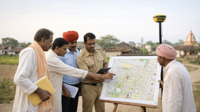
The SVAMITVA Scheme uses drone surveys and Continuously Operating Reference Stations (CORS) technology. This helps create highly accurate maps of rural inhabited areas called abadi lands. These maps clearly mark property boundaries. Accurate mapping reduces disputes over land ownership. It also forms the basis for a Record of Rights which is a legal document for property ownership.
Preparation and Distribution of Property Cards
After drone surveys, the States/UTs conduct ground truthing to verify data. Property cards are then prepared and distributed to landowners. These cards serve as official proof of ownership. They help in accessing loans and resolving property conflicts. The Ministry of Panchayati Raj funds Survey of India for surveys and maps, while States/UTs handle card preparation and distribution.
Gender Inclusion and Ownership Rights
The Ministry does not maintain gender-wise data of beneficiaries. However, several states have introduced co-ownership provisions for women on property cards. States like Madhya Pradesh, Haryana, Karnataka, Mizoram, Chhattisgarh, Jammu & Kashmir, Puducherry, Daman & Diu, and Dadra Nagar Haveli support joint ownership. This promotes women’s property rights and gender equality in rural land ownership.
Monitoring and Implementation Status
Continuous engagement between the Ministry, Survey of India, and States/UTs ensures timely progress. As of March 2026, 3.29 lakh villages have completed drone surveys, nearing the target of 3.44 lakh. The scheme’s success depends on accurate mapping, effective ground verification, and transparent property card distribution. It aims to empower rural citizens with clear ownership rights.
Topics for Prelims:
SVAMITVA Scheme
- Launched to map rural inhabited lands using drones.
- Targets 3.44 lakh villages across India.
- Uses Continuously Operating Reference Stations technology.
- Prepares and distributes property cards to landowners.
- Reduces property disputes by clear demarcation.
Drone Survey Technology
- Enables high accuracy mapping of rural areas.
- Complements ground truthing for verification.
- Funded by Ministry of Panchayati Raj through Survey of India.
- Supports creation of Record of Rights.
- Improves land governance and transparency.
Women’s Property Rights in SVAMITVA
- Some states allow co-ownership of property cards.
- Promotes gender equality in rural land ownership.
- States include Madhya Pradesh, Haryana, Karnataka, etc.
- Ministry does not maintain gender-wise beneficiary data.
- Supports women empowerment in rural India.
Questions for Mains:
- Discuss the role of drone technology in enhancing rural land governance and property rights in India. [GS-III-Science & Technology]
- Critically examine the impact of accurate land records on rural economic development and dispute resolution. [GS-III-Economic Development]
- Explain the significance of gender-inclusive property ownership in rural India and its implications for social justice. [GS-II-Social Justice]
- With suitable examples, discuss the challenges and opportunities in implementing large-scale land mapping schemes like SVAMITVA in India. [GS-II-Governance]
Answer Hints:
1. Discuss the role of drone technology in enhancing rural land governance and property rights in India. [GS-III-Science & Technology]
- Drone surveys enable high-accuracy mapping of rural abadi lands using CORS technology.
- Facilitates clear demarcation of property boundaries, reducing ambiguity and disputes.
- Supports creation of legally valid Record of Rights and property cards for landowners.
- Improves transparency and efficiency in land governance and record maintenance.
- Enables faster, cost-effective, and scalable land surveys compared to traditional methods.
- Enhances integration of technology in rural development and governance frameworks.
2. Critically examine the impact of accurate land records on rural economic development and dispute resolution. [GS-III-Economic Development]
- Accurate land records provide legal proof of ownership, facilitating access to credit and loans.
- Reduces property disputes by clearly defining boundaries and ownership rights.
- Encourages investment in land and agriculture, boosting rural economic activities.
- Improves land market transparency and reduces corruption in land transactions.
- Enables efficient land taxation and better resource planning by governments.
- However, challenges include ground verification, data accuracy, and inclusivity of marginalized groups.
3. Explain the significance of gender-inclusive property ownership in rural India and its implications for social justice. [GS-II-Social Justice]
- Co-ownership provisions promote women’s rights and empowerment in rural property ownership.
- Helps reduce gender disparities in land ownership and economic independence.
- Enhances women’s social status and decision-making power within families and communities.
- Supports legal recognition of women’s claims, reducing vulnerability to dispossession.
- Several states (MP, Haryana, Karnataka, etc.) have adopted co-ownership in SVAMITVA scheme.
- Gender-inclusive ownership aligns with broader goals of social justice and equality.
4. With suitable examples, discuss the challenges and opportunities in implementing large-scale land mapping schemes like SVAMITVA in India. [GS-II-Governance]
- Challenges include coordination among multiple agencies (Ministry, Survey of India, States/UTs) and ground truthing accuracy.
- Technical issues such as drone operation, data processing, and maintaining updated records.
- Ensuring inclusivity and addressing gender and marginalized groups’ rights.
- Opportunities include improved land governance, reduced disputes, and empowerment of rural citizens.
- Example – Uttar Pradesh’s large-scale preparation and distribution of property cards shows scalability.
- Government funding support and technological integration enhance scheme effectiveness and transparency.