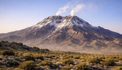
A quiet volcano in southeastern Iran has shown signs of renewed internal activity. Mount Taftan has risen by about 9 cm (3.5 inches) over a span of ten months, according to a recent satellite-based study. Though the uplift appears modest, scientists argue that it signals pressure accumulation beneath the summit — a development that warrants closer monitoring in a region with limited ground-based instrumentation.
How Scientists Detected the Ground Movement
The uplift was detected using Interferometric Synthetic Aperture Radar (InSAR), a remote sensing technique that measures subtle ground deformation from space. Data from the European Space Agency’s Sentinel-1 satellites allowed researchers to track surface changes continuously, regardless of cloud cover or daylight conditions.
The deformation:
- Lasted a little over ten months
- Was centred near the summit
- Has not subsided yet
- Occurred without triggers such as heavy rainfall or earthquakes
Because Taftan is remote and lacks continuous GPS or seismic stations, satellite radar remains the primary monitoring tool.
What Lies Beneath: Shallow Gas Pressure
Modelling suggests the pressure source lies just 490–630 metres below the surface. This shallow depth indicates a hydrothermal system — where hot fluids and volcanic gases circulate — rather than fresh magma rising directly upward.
Deeper magma reservoirs beneath Taftan are estimated to lie more than 3.2 km below the surface. The present uplift likely results from gases accumulating in fractures above this magma chamber. As gas pressure builds, it pushes the ground upward. Once cracks open and gases escape, the uplift rate slows — a pattern observed in this case.
Is Taftan an “Extinct” Volcano?
Taftan stands about 3,940 metres high and is classified as a stratovolcano, built from layers of lava and ash. Although it has no confirmed eruptions in recorded human history, it continues to emit gases through summit fumaroles.
The absence of recent eruptions does not necessarily indicate extinction. Volcanoes can remain dormant for centuries before reactivating. Modern volcanology increasingly relies on measurements of gas emissions, ground deformation, and seismicity — rather than historical eruption records alone — to assess activity levels.
Potential Hazards: Steam Blasts Over Lava Flows
At present, scientists do not suggest an imminent magmatic eruption. Instead, the more immediate concern is the possibility of phreatic (steam-driven) explosions. These occur when hot underground fluids rapidly convert to steam, causing sudden blasts without magma reaching the surface.
Potential risks include:
- Sudden steam explosions near the summit
- Release of sulfur-rich gases
- Short-term air quality impacts
- Localized ash or debris ejection
The nearby city of Khash, about 50 km away, could occasionally experience sulfur odors if gas emissions intensify.
Tectonic Setting and Broader Context
Taftan lies within a tectonically active subduction zone, where one plate descends beneath another. Such settings commonly produce gas-rich magmatic systems and long-lived hydrothermal activity.
Globally, many volcanoes exhibit similar minor uplifts without culminating in eruptions. However, sustained or accelerating deformation can indicate changing subsurface dynamics. Continuous monitoring helps distinguish between routine pressure adjustments and escalating unrest.
Why Satellite Monitoring Matters
In remote terrains where installing and maintaining ground instruments is difficult, satellites provide a cost-effective early warning system. Sentinel-1’s repeated radar passes enable scientists to build time-series maps of surface motion, detecting changes as small as a few millimetres.
Effective volcanic risk management ideally combines:
- Satellite-based deformation tracking
- Ground-based GPS and seismometers
- Gas emission measurements (SO₂, CO₂)
- Public hazard mapping and preparedness planning
What to Note for Prelims?
- Mount Taftan is a stratovolcano located in southeastern Iran.
- Recent uplift measured at approximately 9 cm over ten months.
- Detected using InSAR technique via Sentinel-1 satellites.
- Likely caused by shallow gas pressure rather than magma ascent.
- Phreatic explosions are steam-driven and may occur without lava eruption.
What to Note for Mains?
- Discuss the role of satellite-based technologies in disaster risk reduction.
- Explain how hydrothermal systems influence volcanic hazards.
- Examine the importance of early warning systems in geologically active regions.
- Analyse the difference between dormant, extinct, and active volcano classifications.