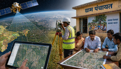
SVAMITVA is a government initiative in India. It aims to provide clear property rights to rural households. The scheme uses technology for land mapping. It helps in resolving land disputes. SVAMITVA promotes financial inclusion. It empowers rural communities through ownership. This initiative supports sustainable development. It enhances the socio-economic status of villagers. Overall, SVAMITVA is crucial for rural reform and development.
ISRO and the Ministry of Panchayati Raj are linked through nationwide land use and land cover mapping, Gram Panchayat-level spatial planning, and the SVAMITVA Scheme. The mapping system...