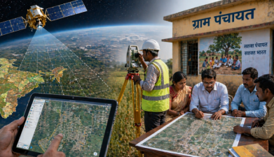
ISRO and the Ministry of Panchayati Raj are linked through nationwide land use and land cover mapping, Gram Panchayat-level spatial planning, and the SVAMITVA Scheme. The mapping system uses satellite data, drone surveys, and geoportals for local planning in India.
Land Use And Land Cover Mapping
ISRO has prepared 1:10,000 scale land use and land cover maps for Panchayat-level planning. These maps use data from CARTOSAT and LISS-IV satellites, which are Indian remote sensing satellites used for Earth observation. The maps are made available through the Bhuvan geoportal, which is ISRO’s geospatial platform.
SVAMITVA Scheme
The SVAMITVA Scheme uses drone-based aerial survey technology and the Continuously Operating Reference Stations, or CORS, network. It creates 1:500 scale maps of village Abadi areas with accuracy up to 5 cm. As of 10 February 2026, the scheme had generated 3.06 crore Property Cards for 1.86 lakh villages, and 31 States and Union Territories had onboarded the scheme.
Digital Platforms For Local Planning
The Grammanchitra portal supports decentralised planning at the Gram Panchayat level. The Bhuvan-Panchayat Geoportal was released during a national workshop on Space-based Information Support for Decentralised Planning-2 in May 2023. The upgraded mobile app for the Gram Panchayat Spatial Development Planning pilot project covers 34 Gram Panchayats across 12 States.
Institutional Framework
The Ministry of Panchayati Raj is working with 17 specialised agencies and institutions, including Schools of Planning and Architecture and IITs, for a common Master Plan framework for States and Panchayats. This framework is linked to spatial planning, land records, and local development planning.
Key Terms For Prelims
- Remote sensing is the collection of information about the Earth without direct contact.
- Geoportals are web-based platforms for accessing spatial data and maps.
- Continuously Operating Reference Stations are fixed GNSS stations used for precise positioning.
- Abadi areas are inhabited village settlement areas.