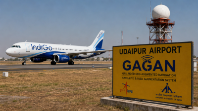
On 27 June 2026 the DGCA conducted India’s first satellite-based landing approach on a commercial IndiGo Airbus A320 at Udaipur Airport using GAGAN’s LPV procedure.
What is GAGAN?
- Full form: GPS Aided GEO Augmented Navigation; an Indian Satellite-Based Augmentation System (SBAS).
- Developers: Jointly developed by ISRO and Airports Authority of India (AAI).
- Primary function: Provides real-time corrections and integrity information to improve GPS position accuracy for safety-critical navigation.
- Operational since: 2015; first SBAS certified for operations in the equatorial region.
- Coverage: Indian Flight Information Region plus a region extending about 1,500 km beyond national boundaries.
Operational features and aviation use
- LPV approaches: Enables Localiser Performance with Vertical Guidance for precision approaches without ground ILS.
- Recent milestone: First satellite-based commercial-jet landing (27 June 2026, Udaipur).
- Procedure rollout: 23 LPV approach procedures published by AAI as of May 2026; target to exceed 40 by end-2026.
- Mandate: DGCA required GAGAN equipment on all Indian-registered aircraft from 1 July 2021.
Other sectors and international links
- Applications: Maritime navigation, road and rail positioning, disaster management, defence, telecoms, high-precision surveying.
- Interoperability: Compatible with WAAS (US), EGNOS (EU) and MSAS (Japan) for cross‑regional navigation.
- Related PNT expansion: 2025 India–South Africa agreement to host a NavIC reference station to extend Indian PNT reach.
IASPOINT Booster Facts
- SBAS concept: GEO satellites broadcast differential corrections and integrity messages to augment GNSS constellations.
- Regulatory link: LPV procedures are part of PBN-based approach design used in civil aviation navigation planning.