
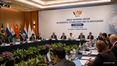
IIT Tirupati hosted the 5th BRICS Working Group on Geospatial Technologies from 20–22 July 2026 under the Department of Science & Technology; delegates from BRICS and partner countries attended in hybrid mode.
Key Technical Themes
- Geospatial infrastructure: Spatial Data Infrastructures (SDI) for sustainable development, disaster management, urban planning, agriculture and environmental monitoring.
- Positioning, Navigation and Timing (PNT): GNSS systems include GPS, GLONASS, Galileo and BeiDou; PNT supports aviation, maritime navigation, telecommunications and emergency response.
- AI-based geospatial analytics: Machine‑learning for feature extraction, land‑use classification and change detection from remote sensing.
- Data interoperability & standards: Use of OGC standards and formats such as GeoJSON, GML, WMS and metadata standards (ISO 19115) for exchange and reuse.
- Geodesy & precise positioning: Reference frames, GNSS augmentation, RTK and PPP for centimetre-to-decimetre positioning accuracy.
Planned Deliverables
- Tirupati Recommendations (2026): Multilateral measures for cooperative geospatial use.
- BRICS Working Group Action Plan (2026–2027): Capacity‑building, joint projects and knowledge exchange.
- BRICS Geodesy & Positioning Cooperation Framework: Harmonisation of reference frames and PNT services.
- Framework for Interoperable Geospatial Data Infrastructure: Common protocols for cross‑border data sharing among member states.
IASPOINT Booster Facts
- GIS: Computer system to capture, store, analyse and display spatial data.
- Remote sensing: Acquisition of information from satellites or airborne sensors using electromagnetic spectrum.
- OGC & ISO: Open Geospatial Consortium and ISO 19115 provide core interoperability and metadata standards.
- India policy: National Geospatial Policy (2022) regulates geospatial data access and institutional roles.