Amid repeated monsoon-triggered landslides in the Bhakra Dam region, the Bhakra Beas Management Board is planning a detailed geological assessment of the surrounding hillocks. The proposed study will be carried out by the Geological Survey of India through a Memorandum of About. It will examine slope stability, rock strength, fault lines and drainage patterns to identify risks and suggest preventive measures.
Why the Study Is Being Planned
The assessment is a precautionary step and not a response to any immediate structural threat to the dam. The aim is to obtain expert advice on strengthening vulnerable slopes and protecting the dam and its associated infrastructure. The need for a scientific review has increased after repeated landslides in recent monsoons.
Key Geological Concerns
- The hillocks around the dam consist mainly of sedimentary and metamorphic rocks.
- These rocks are prone to weathering, erosion and slope failure.
- The Shivalik terrain is known for loose debris and fragile slopes.
- Heavy rainfall, seismic activity and human intervention can worsen instability.
Past Monsoon Disruptions
Last year, intense rainfall caused several slope failures in the hills near the dam and along the approach routes from Nangal. Road and railway links were blocked, affecting movement of personnel and essential supplies. Debris and muck also entered the powerhouse complex, though the situation was contained in time and major operational disruption was avoided.
Possible Mitigation Measures
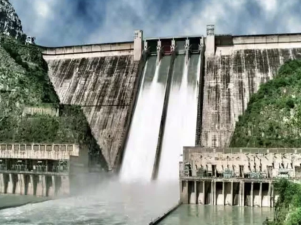
Based on the findings, the BBMB may take reinforcement measures to improve slope safety. These may include rock bolting, retaining walls, improved drainage systems and bio-engineering solutions. The study is also expected to help in long-term risk reduction for one of India’s tallest gravity dams, which stands about 226 metres high and is backed by the Gobind Sagar reservoir.
Last Modified: April 28, 2026