Mission Mausam is a government programme launched by the Ministry of Earth Sciences in 2026. It aims to improve the accuracy, timeliness, and reliability of weather forecasts and early warning systems in India. The mission focuses on extreme weather events and climate services to enhance disaster preparedness and public safety.
Objectives and Implementation
Mission Mausam seeks to strengthen weather and climate prediction capabilities. It involves upgrading observation networks and enhancing numerical weather prediction models. The mission also expands high-performance computing (HPC) capacity and integrates Artificial Intelligence (AI) and Machine Learning (ML) for advanced forecasting. The India Meteorological Department (IMD), Indian Institute of Tropical Meteorology (IITM), and National Centre for Medium Range Weather Forecasting (NCMRWF) are key institutions implementing the mission. The phased implementation will continue until 2031.
Technological Enhancements
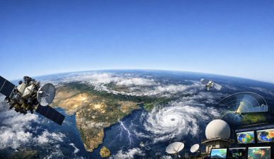
The mission upgrades Automatic Weather Stations (AWS), Automatic Rain Gauges (ARG), and Doppler Weather Radars across India. It establishes the Atmospheric Research Testbed (ART) in Madhya Pradesh to study monsoon convection and rainfall variability. AI and HPC systems enable better data assimilation from atmospheric, oceanic, and satellite sources. This leads to improved forecast accuracy and longer lead times for warnings on cyclones, floods, heatwaves, and other hazards.
Dissemination and Impact
Weather forecasts and warnings are shared via mobile apps like MAUSAM, MEGHDOOT, and DAMINI, along with SMS, TV, radio, and social media. The mission ensures coverage in all states and remote regions. Sector-specific advisories help farmers, fishermen, disaster managers, and the public prepare for weather changes. Improved forecasts assist crop planning, fishing operations, and disaster response, reducing risks and losses.
Significance for Various Sectors
In agriculture, better monsoon forecasts aid irrigation and crop protection. In fisheries, ocean advisories from the Indian National Centre for Ocean Information Services (INCOIS) improve safety and efficiency. Disaster management benefits from early warnings for extreme events, enabling timely evacuations. Overall, Mission Mausam aims to make India Weather Ready and Climate Smart.
Topics for Prelims:
Mission Mausam
- Launched in 2026 by Ministry of Earth Sciences.
- Focuses on weather forecasting and early warnings.
- Implemented by IMD, IITM, NCMRWF, and other institutions.
- Uses AI, HPC, and upgraded observation networks.
- Phased implementation until 2031.
Atmospheric Research Testbed (ART)
- Located in Silkheda, Madhya Pradesh.
- Studies monsoon convection and rainfall variability.
- Addresses data gaps in central India.
- Supports cloud microphysics and land-atmosphere research.
- Enhances understanding of boundary layer processes.
Indian National Centre for Ocean Information Services (INCOIS)
- Provides ocean and weather advisories.
- Supports fisheries through Potential Fishing Zone (PFZ) data.
- Uses satellite data for ocean monitoring.
- Improves safety of fishermen in Indian waters.
- Collaborates with Ministry of Earth Sciences.
Questions for Mains:
- Discuss the role of Artificial Intelligence and High-Performance Computing in improving weather forecasting accuracy in India. [GS-III-Science & Technology]
- Critically examine the impact of improved weather forecasting on agriculture and disaster management in India. [GS-III-Economic Development]
- Explain the significance of observational networks like Automatic Weather Stations and Doppler Radars in meteorology. How do they contribute to early warning systems? [GS-III-Environment & DM]
- With suitable examples, discuss the integration of oceanic and atmospheric data in climate services and its importance for coastal communities. Comment on the challenges faced in such integrations. [GS-II-International Relations]
Answer Hints:
1. Discuss the role of Artificial Intelligence and High-Performance Computing in improving weather forecasting accuracy in India. [GS-III-Science & Technology]
- AI and ML enable advanced pattern recognition and data assimilation from diverse meteorological datasets.
- High-Performance Computing (HPC) allows processing of large-scale atmospheric, oceanic, and satellite data in real-time.
- Improves numerical weather prediction models by increasing resolution and reducing prediction errors.
- Facilitates longer lead times and more reliable forecasts for extreme weather events like cyclones, floods, and heatwaves.
- Supports development of impact-based forecasting enhancing preparedness and response.
- Integral to Mission Mausam’s objective of making India Weather Ready and Climate Smart.
2. Critically examine the impact of improved weather forecasting on agriculture and disaster management in India. [GS-III-Economic Development]
- Accurate monsoon and weather forecasts aid crop planning, irrigation scheduling, and pest management.
- Reduces crop losses by enabling timely protective measures against droughts, floods, and heatwaves.
- Improved early warnings support disaster preparedness, evacuation, and resource allocation for floods, cyclones, and heatwaves.
- Enhances resilience of vulnerable communities and reduces economic losses from extreme weather events.
- Sector-specific advisories (farmers, disaster authorities) improve decision-making and response efficiency.
- Challenges include reaching remote areas and ensuring last-mile dissemination of warnings.
3. Explain the significance of observational networks like Automatic Weather Stations and Doppler Radars in meteorology. How do they contribute to early warning systems? [GS-III-Environment & DM]
- AWS and Doppler Radars provide real-time, high-resolution data on temperature, rainfall, wind, and atmospheric conditions.
- Enhance monitoring of localized weather phenomena such as thunderstorms, cyclones, and rainfall intensity.
- Fill data gaps, especially in remote and vulnerable regions, improving spatial coverage of observations.
- Support numerical weather prediction models with accurate input data, improving forecast reliability.
- Enable timely detection and tracking of extreme events, facilitating early warnings and disaster preparedness.
- Integral to Mission Mausam’s strategy to strengthen observation networks for better weather services.
4. With suitable examples, discuss the integration of oceanic and atmospheric data in climate services and its importance for coastal communities. Comment on the challenges faced in such integrations. [GS-II-International Relations]
- Integration of oceanic (sea surface temperature, waves, currents) and atmospheric data improves accuracy of cyclone and storm surge forecasts.
- Institutions like INCOIS provide Potential Fishing Zone advisories using satellite ocean data, benefiting fishermen safety and livelihoods.
- Helps coastal disaster management by enabling early warnings for tsunamis, cyclones, and floods.
- Supports climate adaptation planning for vulnerable coastal populations dependent on marine resources.
- Challenges include data heterogeneity, real-time assimilation complexities, and coordination among multiple agencies.
- Technological and infrastructural limitations in remote coastal regions hinder effective data integration and dissemination.