Joshimath, a small town in Uttarakhand’s Chamoli district, is currently facing a crisis as 723 houses in all nine of the town’s wards have developed major or minor cracks on the floors, ceilings and walls. Beams have also been dislodged in many houses. The first cracks appeared in a few houses in October 2021, but the administration failed to take adequate steps. After more cracks appeared in buildings this January, 145 families have been temporarily relocated to safer locations within the town while a debate on the future of Joshimath rages.
Seismic Zones and Joshimath
- Joshimath is located in Zone V of India’s seismic zonation scheme, which denotes a high-risk area. It is also worth noting that the Indian Space Research Organisation (ISRO) said in a report that the town in Uttarakhand sank 5.4 cm between December 27, 2022, and January 8, 2023.
- However, the report and the satellite images were later withdrawn from the ISRO website. The National Disaster Management Authority (NDMA) has directed all departments and organizations associated with survey and data collection in Joshimath not to interact with the media or share any data on social media.
- A seismic zone is an area where there is a high probability of earthquakes due to the area’s geology. Seismic zonation, which involves dividing areas based on expected ground motion, assesses the hazards related to earthquakes in such areas to provide inputs for safer constructions and other practices.
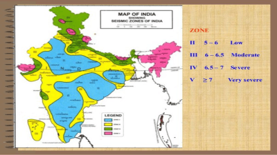
India’s Seismic Zone Maps
- According to the 2002 version of India’s seismic zone map, earthquake-prone regions in the country are divided into four zones zone II, III, IV, and V based on intensity levels during past earthquakes. However, this is not the version of the map that has always been in use.
- The first national seismic zoning map of India was compiled by the Geological Survey of India in 1935, after the 1934 Nepal-India earthquake that measured over 8.0 on the Richter scale and destroyed Kathmandu, Bhaktapur and Patan in Nepal. It consisted of three zones severe, light, and minor hazard, based on the broad concept of space-time earthquake statistics and the prevailing understanding of geotectonic movements, as stated in a research paper by scholars A.K. Mohapatra and W.K. Mohanty.
- In 1962, the Bureau of Indian Standards (BIS) published a seismic zonation map of India. This map marked earthquake epicenters in the country and built on the is seismic map published by the GSI in 1935. It divided India into seven zones from 0 (no damage) to VI (extensive damage). It was reviewed in 1966, using geological and tectonic features to modify the zones.
- In 1967, a 6.3-magnitude earthquake struck the Koyna hydroelectric project, killing hundreds of people and injuring thousands. This led to major revisions in the 1970 seismic zone map of India. The 1970 map consisted of five zones I, II, III, IV, and V based on the Modified Mercalli Intensity (MMI) scale with a Comprehensive Intensity Scale (CIS-64). The MMI scale takes into account the effect of earthquakes on people, objects, and buildings, and estimates the shaking intensity from an earthquake at a specific location. Zero was removed as a zone since it was deemed scientifically inappropriate to consider a region completely safe from earthquakes. Another major change in the 1970 version of the map was the merging of zones V and VI.
- In 1984, a new update to India’s seismic zone map was released. This map identified the seismic potential of regions based on past earthquakes and the tectonic setting of the area. The zone boundaries were redrawn to reflect the updated information.
Synopsis
In the light of recent events in Joshimath, it is important to note that India’s seismic zone maps have been revised multiple times in the past to reflect the updated information and understanding of the seismic activity in the country. However, it is also important to consider that even with the best data and understanding, it is impossible to predict when and where earthquakes will occur. It is crucial that adequate steps are taken to ensure the safety of buildings and citizens in high-risk areas.
Last Modified: February 19, 2024