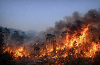
Forest fires in India during early 2026 have surged alarmingly. Data shows an 80% rise in fire incidents compared to the past decade. The intensity of these fires has also increased, especially in North East India, the Himalayas, Odisha, and Rayalaseema. This marks a severe fire season with early onset and prolonged activity.
Increase in Forest Fires and Intensity
Forest fires from January to February 2026 rose sharply. Compared to 2024, the warmest year recorded, fire activity was over 50% higher. Fire intensity, measured by thermal energy released, also climbed. North East India, including Arunachal Pradesh and Nagaland, reported some of the most intense fires. Other affected areas include Himachal Pradesh, Uttarakhand, Odisha, and Rayalaseema in southern India.
Geographical Spread and Impact
Fires have expanded beyond traditional hotspots. The Himalayan states saw early and intense fires. Uttarakhand recorded 114 fires between November 2025 and March 2026, affecting about 84 hectares of forest. North East India experienced large forest fires lasting over a week. These fires led to evacuations and required aerial firefighting efforts.
Firefighting Efforts and Challenges
The Indian Air Force and Army joined firefighting operations in remote and high-altitude areas. Helicopters dropped over 12,000 litres of water in Arunachal Pradesh’s Lohit valley. Fighting fires at elevations above 2,800 metres posed logistical challenges. Prolonged smoke and fire have affected local communities and ecosystems.
Data and Monitoring Techniques
Forest fire trends were analysed using NASA’s FIRMS satellite data combined with OpenStreetMap forest boundaries. FIRMS measures fire radiative power, indicating fire intensity. This data helps track fire location, intensity, and duration. Early detection aids in deploying timely firefighting resources.
Topics for Prelims:
Forest Fires in India
- Forest fires increased by 80% in early 2026 compared to 2014-2024.
- North East India and Himalayan states are major affected regions.
- Fire intensity measured by fire radiative power from satellite data.
- Early onset of fire season noted in Uttarakhand and other states.
- Aerial firefighting by IAF and Army used in remote high-altitude areas.
NASA FIRMS and Fire Monitoring
- FIRMS uses satellite thermal sensors to detect fires globally.
- Fire radiative power measures energy emitted by fires.
- Data helps in real-time fire detection and intensity analysis.
- OpenStreetMap data used to map forest boundaries for analysis.
- Satellite monitoring aids early warning and resource deployment.
Questions for Mains:
- Critically analyse the impact of rising forest fires on biodiversity and local communities in India. [GS-III-Environment & DM]
- With suitable examples, estimate the role of satellite technology in managing natural disasters like forest fires. [GS-III-Science & Technology]
- Point out the challenges faced by Indian armed forces in aerial firefighting operations in mountainous regions and suggest improvements. [GS-III-Internal & External Security]
- Underline the connection between climate change and increasing forest fire incidents in India, and discuss policy measures to mitigate these risks. [GS-III-Environment & DM]
Answer Hints:
1. Critically analyse the impact of rising forest fires on biodiversity and local communities in India. [GS-III-Environment & DM]
- Forest fires cause large-scale habitat destruction, threatening flora and fauna diversity.
- Loss of endemic and endangered species due to habitat fragmentation and mortality.
- Air pollution from smoke affects human health, especially respiratory illnesses in local communities.
- Displacement and evacuation disrupt livelihoods, especially of forest-dependent tribal populations.
- Soil degradation and loss of forest cover reduce ecosystem services like water retention and carbon sequestration.
- Frequent fires alter forest regeneration patterns, impacting long-term ecological balance.
2. With suitable examples, estimate the role of satellite technology in managing natural disasters like forest fires. [GS-III-Science & Technology]
- NASA FIRMS uses thermal sensors to detect fire locations and intensity in near real-time globally.
- Fire Radiative Power (FRP) quantifies fire intensity, aiding prioritization of firefighting efforts.
- Satellite data integrated with forest maps (OpenStreetMap) improves accuracy of fire monitoring.
- Early detection enables timely deployment of resources, reducing spread and damage.
- Examples – FIRMS data used to monitor intense fires in North East India and Himalayas in 2026.
- Supports planning of aerial firefighting and evacuation by providing fire progression trends.
3. Point out the challenges faced by Indian armed forces in aerial firefighting operations in mountainous regions and suggest improvements. [GS-III-Internal & External Security]
- High altitude (above 2,800 m) poses physiological stress and operational difficulty for personnel and equipment.
- Rugged terrain limits helicopter maneuverability and water refill points.
- Weather unpredictability and wind intensify fire spread and complicate firefighting.
- Limited availability of specialized firefighting aircraft and trained personnel for mountain operations.
- Improvements – Enhance training for high-altitude aerial firefighting and increase specialized fleet.
- Develop better coordination with local agencies and invest in aerial water sources like portable reservoirs.
4. Underline the connection between climate change and increasing forest fire incidents in India, and discuss policy measures to mitigate these risks. [GS-III-Environment & DM]
- Rising temperatures and prolonged dry spells due to climate change increase forest fire frequency and intensity.
- Early onset and longer fire seasons linked to shifting climate patterns observed in Uttarakhand and North East India.
- Climate-induced drought stresses forests, making them more flammable and vulnerable.
- Policy measures – Implement integrated forest fire management plans incorporating climate projections.
- Promote community-based forest management and early warning systems using satellite data.
- Strengthen afforestation, controlled burning, and climate adaptation strategies to reduce fire risks.