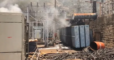
A major fire broke out at the Machkund Hydroelectric Project located on the Odisha-Andhra Pradesh border on May 23, 2026. The blaze erupted inside the underground turbine section, quickly filling the chambers with dense, suffocating smoke and triggering panic. Emergency responders and plant staff successfully rescued trapped employees from the underground installation, with four workers receiving medical treatment for smoke inhalation. Preliminary assessments by technical teams point to an electrical short circuit or a sudden technical malfunction within one of the turbine panel boards as the primary cause.
Project Overview and Geographical Setting
Location and Topography
The Machkund Hydroelectric Project is situated on the western slopes of the Eastern Ghats. It is positioned near the Duduma Falls in the Koraput district of Odisha, right along the interstate boundary with the Alluri Sitharama Raju district of Andhra Pradesh.
Hydrological Profile
The project harnesses the water resources of the Machkund River, which originates in the Mudugal hills of Andhra Pradesh. In its lower reaches, this river is known as the Sileru River. The Machkund-Sileru system forms a crucial component of the larger Godavari River basin.
Structural and Operational Features
Installed Capacity and Infrastructure
The power plant has an operational nameplate capacity of 120 Megawatts (MW). The generation infrastructure relies on conventional storage technology spread across six generation units:
| Generation Unit Configuration | Turbine Capacity | Engineering Make |
| Stage I (Units 1, 2, and 3) | 3 x 17 MW | Westinghouse, USA |
| Stage II (Units 4, 5, and 6) | 3 x 23 MW | Brown Boveri, Switzerland |
Associated Reservoirs and Water Regulation
- Jalaput Dam: A primary storage reservoir with a gross storage capacity of 34.27 Thousand Million Cubic Feet (TMC ft) built at Jalaput to impound the Machkund River.
- Diversion Dam: Located 17 kilometers downstream of the Jalaput Dam and just 1.5 miles above the Duduma Falls, this structure diverts regulated water releases directly into the power canal to feed the turbine generation unit.
Interstate Power Sharing and Governance
Historical Evolution
The original idea for a power plant in this location dates back to the 1920s, proposed by Maharaja Vikram Dev Varma of Jeypore to electrify local villages. Formal construction began in 1948 under an interstate agreement signed in 1945 between the governments of Madras (later Andhra Pradesh) and Odisha. The facility entered commercial service in 1955 and was inaugurated by India’s first President, Dr. Rajendra Prasad.
Revised Allocation Framework
Initially, capital expenditures and electricity benefits were split in a 70:30 ratio between Andhra Pradesh and Odisha. A bilateral agreement signed on October 23, 2020, updated this arrangement to an equal 50:50 cost-and-benefit sharing model. This agreement governs the modern Renovation, Modernization, and Uprating (RM&U) works of the aging power station.
Consumer Base
The 120 MW grid output serves as a baseline power supply for several key urban and rural areas across both states:
- Andhra Pradesh: Supplies critical power load centers in Visakhapatnam and Vijayawada.
- Odisha: Powers regional grids in the Koraput and Jeypore areas.
Technical and Safety Implications of the Incident
Vulnerability of Aging Infrastructure
The fire highlights safety challenges associated with vintage hydroelectric machinery. Electrical panels, wiring networks, and control boards installed during earlier modernization phases face rapid thermal degradation under prolonged heavy loads, increasing short-circuit vulnerabilities.
Underground Evacuation and Safety Risks
Hydroelectric generator halls located in underground caverns pose high evacuation challenges during fire emergencies. The rapid buildup of carbon monoxide and dense plastic smoke inside poorly ventilated turbine pits creates immediate suffocation hazards, requiring dedicated breathing apparatus and specialized smoke extraction loops for rescue operations.
IASPOINT Booster Facts for UPSC
- Dandakaranya Region: The Sileru (Machkund) River defines the eastern boundary of the unique Dandakaranya physiographic region, a historical and ecological zone spanning parts of Odisha, Chhattisgarh, and Andhra Pradesh.
- Hydroelectric Terminology: The vertical water wheels used at Machkund operate under a gross head of 844 feet, transforming the potential energy of stored water into mechanical energy via Francis or Pelton-type hydraulic turbines.
- Interstate River Water Disputes: Unlike complex river disputes managed under Article 262 of the Constitution, the Machkund arrangement stands out as a successful long-term bilateral water-and-power sharing partnership managed via mutual state board agreements.
- Downstream Cascading Projects: The water discharged from the Machkund tailrace channel feeds directly into downstream projects on the Sileru River, including the Balimela Hydroelectric Project (Odisha) and the Upper Sileru and Lower Sileru power stations (Andhra Pradesh).