The recurrent floods of North Bihar represent a complex intersection of geographical inevitability, historical engineering choices, and contemporary governance gaps. For decades, the region has been defined by a predictable yet devastating pattern of monsoon rainfall, immense sediment loads from the Himalayas, embankment stress, and the systemic failure of drainage networks. While the physical nature of these floods is well-documented, significant uncertainty remains regarding how flood damage is officially assessed, whose specific losses are rendered visible to the state, and how this body of evidence eventually shapes public policy. A recent household-level flood loss assessment offers a rare and critical window into these questions, exposing fundamental gaps in India’s current flood governance framework.
The Household-level Bihar Flood Loss Assessment 2024
The Household-level Bihar Flood Loss Assessment 2024 was a granular study conducted by Megh Pyne Abhiyan with support from Tata Trusts. This assessment followed the “Phase 2” floods of late September 2024, providing data that official statistics often overlook. By surveying 2,290 households across seven key districts—Paschim Champaran, Sitamarhi, Darbhanga, Madhubani, Saharsa, Supaul, and Kishanganj—the study captured a more comprehensive picture of the disaster’s impact.
Key Findings of the Assessment
- Scale of Economic Loss: The total economic loss across the surveyed households was estimated at ₹126.3 crore. While the average loss per household stood at ₹5.51 lakh, the median loss was ₹2.11 lakh. This discrepancy indicates that even “moderate” damage is catastrophic for low-income families who have fewer reserves.
- The “Invisible” Damage:
- Land Damage: This accounted for 43.8% (₹55.4 crore) of total losses, making it the single largest category of loss due to erosion and sand deposition.
- Housing: Reconstruction costs made up 33.6% (₹42.5 crore) of the total, affecting nearly 2,000 households.
- Daily Essentials: Losses involving food stocks, kitchenware, and sanitation materials were widespread. Despite their impact on daily survival, these items often remain uncounted in high-level policy metrics.
- The Vulnerability Paradox: The report highlights a critical disparity: while “asset-rich” households report higher absolute monetary losses, marginalised communities (SC/ST) suffer more profoundly in relative terms. For instance, 36% of ST households were forced to mortgage land and 56% mortgaged livestock to survive the immediate aftermath.
- Institutional Gaps: Approximately 80% of families were either unaware of or lacked access to flood insurance. Consequently, recovery is largely financed through high-interest informal loans (67% of households) and distress asset sales.
Critical Gaps in Indian Flood Governance
The assessment exposes three major failures in the current Indian framework:
- Blunt Metrics: Current policy relies heavily on district-level aggregates—such as hectares submerged or lives lost—that fail to capture the “lived experience” of household-level impoverishment and the long-term debt traps created by the floods.
- Redistributed Risk: Embankments, which serve as the primary structural defense, often redistribute rather than eliminate risk. Families living outside embankments suffered roughly ₹80 crore in losses, compared to ₹13 crore for those within, illustrating how protection for some can increase vulnerability for others.
- Reactive vs. Proactive: Governance remains largely relief-centric, focusing on immediate aid rather than long-term resilience strategies like owner-driven reconstruction and community-managed early warning systems.
Recommendations for a Policy Shift
- Typology-Sensitive Planning: Moving away from “one-size-fits-all” responses toward strategies tailored to specific flood types, such as breach-induced floods versus drainage failure.
- Financial Safety Nets: Introducing community-led micro-insurance and “resilience vouchers” specifically for reconstruction.
- Inclusive Evidence: Integrating household damage registries and local indigenous knowledge into official compensation frameworks to ensure no one is left behind.
Structural and Environmental Drivers of North Bihar Floods
The recurrent floods in North Bihar are the result of a complex interplay between the region’s natural geography and decades of engineering interventions that have frequently exacerbated the problem.
1. Geographical & Environmental Triggers
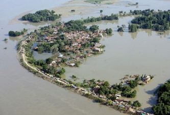
- The “Bowl” Topography: North Bihar is a flat alluvial plain situated directly below the Himalayas. Rivers like the Kosi, Gandak, Bagmati, and Kamla Balan rush down from steep slopes into these flatlands. When the gradient drops, water velocity decreases, causing sediment to settle rapidly.
- Sediment Overload: The Himalayas are geologically active with loose soil. Rivers carry immense silt loads that deposit on riverbeds, raising them above the surrounding land. This is particularly severe in the Kosi river, known as the “Sorrow of Bihar.”
- Rainfall Patterns: The region depends on a concentrated monsoon season (June–September). Intense precipitation, combined with heavy upstream rains in Nepal, frequently overwhelms river channels.
2. The “Embankment Trap”
Since the 1950s, the state has focused on building embankments to “jacket” the water. This has created several unintended consequences:
- Rising Riverbeds: By confining the river, embankments prevent silt from spreading over floodplains. Instead, silt accumulates in the channel, raising the riverbed so that the river often flows at a level higher than the surrounding villages.
- Drainage Congestion: Embankments block natural drainage from the countryside into the river. Rainwater accumulates in fields and cannot flow out, leading to permanent waterlogging in low-lying areas known as chaurs.
- False Security: These structures encourage settlement closer to the banks. When an embankment breaches, the resulting flash floods are far more destructive than the slow-rising natural floods of the past.
The Official Damage Assessment Mechanism
In India, flood damage assessments function more as bureaucratic tools for releasing relief funds than as scientific exercises for understanding vulnerability.
1. The Relief-Centric Hierarchy
- The “Eye Estimation”: Local Patwaris (village accountants) conduct rapid visual surveys to produce quick numbers on hectares submerged and houses collapsed to trigger the State Disaster Response Fund (SDRF).
- The Memorandum: The state compiles these reports into a Relief Memorandum for the Central Government if the disaster is deemed “severe.”
- The Central Team: An Inter-Ministerial Central Team (IMCT) verifies these claims to release funds from the National Disaster Response Fund (NDRF).
- The Flaw: This system asks how much money the State needs for immediate compensation, not how the household’s economic trajectory has been altered.
2. Methodological Gaps: The “Invisible” Losses
The system is built for compensation and only “sees” what can be easily counted and legally verified.
| Visible Losses (The “Counted”) | Invisible Losses (The “Uncounted”) | Why it Matters |
| Landed Assets: Crop damage on revenue-recorded land; collapsed houses. | Informal Livelihoods: Lost crop shares of landless tenants; destroyed vendor carts. | Excludes the poorest: The landless show zero recorded loss because they own no land. |
| Direct Economic Costs: Repairing bridges/roads; livestock compensation. | Opportunity Costs: Daily wage loss; distress sale of cattle; high-interest survival loans. | Misses the debt trap: Families mortgage their future to recover, a loss never recorded. |
| Public Infrastructure: Breached embankments; damaged schools. | Household Resilience Assets: Stored food grains, firewood, fodder, and sanitation facilities. | Undermines recovery: Losing food stocks creates immediate insecurity but is rarely compensated. |
| Lives Lost: Direct drowning deaths. | Morbidity & Health: Post-flood waterborne diseases; maternal health complications. | Hidden health crisis: Long-term health burdens are treated as separate from flood loss. |
3. Institutional Blind Spots
- The “All-or-Nothing” Trap: Compensation is often binary. A house must be “fully destroyed” to qualify, leaving those with uninhabitable, damp homes with nothing.
- The Paperwork Barrier: Compensation is tied to formal ownership. If a river erodes land never formally surveyed (common in diara areas), the loss officially does not exist.
- Flawed Evidence/Policy: Data focuses on asset protection (saving land) rather than people protection. This leads to an “Embankment Bias” while ignoring the opportunity costs of prolonged inundation.
International Comparisons in Disaster Risk Management
Compared to international best practices, India’s framework remains tethered to “revenue records,” whereas global models focus on Total Economic Value.
- Philosophy: While India provides “Gratuitous Relief” (ex-gratia survival aid), countries like the USA (FEMA) use a “Risk Transfer” model involving national insurance programs that calculate the actual cost of repairs.
- Methodology: While India uses “Eye Estimation,” the EU mandates comprehensive risk management including intangible losses like cultural heritage. International standards use “Depth-Damage Functions” to predict loss based on water physics rather than just visual inspection.
- Visibility: International standards, such as the Post-Disaster Needs Assessment (PDNA) developed by the UN and World Bank, calculate “Losses” (changes in economic flows/income) separately from “Damages” (physical destruction). India has adopted the PDNA manual, but it is rarely used for immediate funding.
- Build Back Better: In Japan, the concept of “Build Back Better” is codified, focusing on community redesign or relocation rather than just patching individual homes to be destroyed in the next cycle.
Strengths and Limitations of Household-Level Assessments
Household-level assessments serve as a “bottom-up” corrective to top-down data.
- Strengths: They provide granularity, capture indirect/intangible losses (like school dropouts), and provide evidence for equitable financing by showing how different demographics recover differently.
- Limitations: They are susceptible to recall bias and strategic bias (exaggeration for aid). They are resource-intensive and often lack the legal standing to trigger payouts due to the “data wall” between civil society and revenue records.
- Policy Power: Their real strength lies in shifting the narrative from “how much land was lost” to “how many futures were derailed.”
Future Frameworks for Inclusive Flood Governance
Transitioning from controlling water to governing risk requires a collaborative architecture of data and policy.
1. Democratizing the “Data Layer”
- “Shadow Registries”: Creating vulnerability registries that run parallel to land titles to include sharecroppers and informal workers.
- Hyper-Local “Social Sensing”: Integrating community-generated data and social media signals with satellite imagery for real-time, verified flood maps.
- Typology-Driven Data: Recording the specific nature of the flood (e.g., sand deposition) to trigger specific reclamation support.
2. Resilience as a “Risk Portfolio”
- Room for the River: Adopting the Dutch approach of “living with water,” designating flood zones, and compensating farmers for “ecosystem services” (storing water).
- Nature-Based Solutions (NbS): Reviving traditional chaurs as buffer zones and implementing “Sponge City” concepts.
- Anticipatory Financing: Using Forecast-based Financing (FbF) to trigger cash transfers before a flood hits, allowing the vulnerable to evacuate without debt.
3. Institutionalizing “Bottom-Up” Governance
- The “Data Bridge” Mandate: Legally mandating the inclusion of non-government “Social Audits” in the official PDNA process.
- Decentralized Command: Empowering Panchayats as “planners” who can identify families hidden from the census, such as seasonal migrants.
Integrating these elements transforms flood governance from a mechanism that merely reimburses damage into one that underwrites long-term stability for the most vulnerable.
Questions
- Distinguish between the “Embankment Trap” and natural riverine dynamics in the context of the Kosi river basin. Why has the structural “jacketing” of rivers historically failed to mitigate flood vulnerability in North Bihar? Explain. (GS-I: Geography)
- What are the challenges before the Indian disaster management framework when shifting from a “Relief-Centric” approach to a “Risk-Transfer” model? How can the integration of household-level data address the invisibility of informal livelihoods? Discuss. (GS-III: Environment & DM)
- Elaborate the significance of “Room for the River” and nature-based solutions as alternatives to traditional flood control infrastructure. To what extent can these strategies promote climate resilience in the alluvial plains of India? (GS-III: Environment & DM)
- The current flood damage assessment in India is often criticized for its reliance on “Eye Estimation” and revenue records. Critically discuss how this methodological gap leads to the marginalization of landless sharecroppers and tenant farmers during disaster recovery. (GS-II: Social Justice)
- Examine the factors responsible for the “Vulnerability Paradox” where marginalized communities suffer higher relative economic shocks despite having fewer recorded assets. What steps can the government take to institutionalize “Forecast-based Financing” for such groups? (GS-II: Governance)
- Critically Analyse the role of local Panchayats and community-managed early warning systems in bridging the “Data Bridge” gap. How can decentralized governance improve the accuracy of Post-Disaster Needs Assessments (PDNA) in India? (GS-II: Governance)