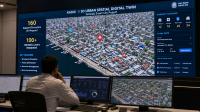
On 19 June 2026 Kashi (Varanasi) launched a 3‑D Urban Spatial Digital Twin to aid emergency planning and urban management.
Key features of Kashi digital twin
- Spatial extent: 3D mapping of 160 sq km covering the municipal corporation area.
- Thematic depth: Over 100 thematic layers including transport, built form, utilities and emergency assets.
- Emergency functions: Queries for nearest fire station, optimal response routes and resource availability during incidents.
Technical components
- LiDAR: Light Detection and Ranging collects high‑resolution elevation and point‑cloud data for 3D models.
- 3D GIS: Geospatial database integrates vector, raster and point‑cloud layers for spatial analysis.
- Custom software: City‑specific application for inter‑departmental access, visualisation and scenario queries.
Implementation and operational facts
- Cost and method: Project completed for Rs. 12.5 crore; aircraft‑based surveys used for 3D GIS mapping.
- Departments: About 10 city departments, including the fire service, received training for operational use.
- Primary use case: Enhances route planning, asset location and coordination for emergency response.
IASPOINT Booster Facts
- Digital twin (definition): A virtual replica of physical assets, processes or systems used for simulation and analysis.
- Data sources: Integrates LiDAR, satellite/airborne imagery, cadastral/GIS data and IoT sensor feeds.
- GIS term: 3D GIS combines spatial coordinates with elevation/height attributes for volumetric analysis.