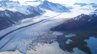
Researchers at the Indian Institute of Technology Guwahati have developed a predictive framework that identifies locations in the Eastern Himalaya where new glacial lakes are likely to form. The study mapped 492 high-risk sites using high-resolution Google Earth images and digital elevation models. It is aimed at improving hazard management, early warning for Glacial Lake Outburst Floods, and long-term water-resource planning in mountain regions.
Key Findings
- The framework identified 492 potential glacial lake formation sites in the Eastern Himalayan mountains.
- The study found that landform structure is a major factor in glacial lake development.
- The most accurate model was the Bayesian Neural Network.
Methods Used
- The team tested three predictive methods – Logistic Regression, Artificial Neural Network, and Bayesian Neural Network.
- High-resolution satellite imagery and digital elevation models were used to capture terrain features.
- The model also estimated uncertainty, making the predictions more realistic and reliable.
Why It Matters
- The framework can support early-warning systems for Glacial Lake Outburst Floods.
- It can help identify safer locations for roads, hydropower projects, and settlements.
- It can assist in climate-resilient planning and disaster-risk reduction in glacier-fed regions.
Future Use
- The researchers plan to include moraine development histories in the model.
- They also aim to automate data preparation for large-scale monitoring.
- Field-based validation is expected to improve accuracy further.