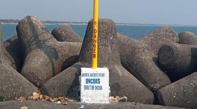
The Indian National Centre for Ocean Information Services (INCOIS) expanded its marine surveillance network by installing a second Coastal Flood Monitoring System (CFMS) near Kollam Harbour in Kerala. This deployment targets the forecasting and tracking of Kallakkadal surges along India’s southwest coast. The initial operational system was deployed at Vizhinjam in 2025, making the Kollam installation the second specialized unit dedicated to nearshore wave transformation monitoring. This framework helps scientists capture real-time marine metrics to protect vulnerable fishing communities and critical maritime infrastructure.
Scientific Mechanism of Kallakkadal Phenonomenon
Kallakkadal represents a distinct category of coastal flooding events triggered by large-scale meteorological conditions in the remote southern latitudes of the Indian Ocean.
Origin and Etymology
- Linguistic Roots: The term originates from the Malayalam words Kallan (meaning thief) and Kadal (meaning sea). It describes high-energy waves that strike the shoreline unexpectedly without the presence of local environmental indicators.
- Global Recognition: The United Nations Educational, Scientific and Cultural Organization (UNESCO) formally approved the term “Kallakkadal” for international scientific nomenclature in 2012.
Wave Dynamics and Generation
Unlike standard wind-driven waves formed by local weather systems, Kallakkadal surges follow a long-distance progression:
- Meteorological Trigger: Intense storms, high-velocity gale winds, or severe atmospheric disturbances occur in the Southern Indian Ocean, typically south of 30°S latitude and nearly 10,000 kilometers away from the Indian peninsula.
- Energy Transference: These remote weather systems transfer atmospheric kinetic energy into the ocean surface, creating long-period surface gravity waves called ocean swells.
- Northward Propagation: The generated swells travel across the open ocean basin for three to five days without losing significant structural energy, arriving at the Indian coastline as clean, uniform wave trains.
- Infragravity Waves: Recent oceanic research connects the phenomenon to low-frequency infragravity waves, which exhibit wave periods extending from 30 to 300 seconds.
- Shoaling Mechanics: When these long-period waves enter shallow coastal zones, they undergo shoaling. This process forces the wave height to increase rapidly due to underwater friction as the water depth decreases. Local underwater topography (bathymetry) further concentrates this energy, resulting in sudden, dry-land inundation.
Temporal Patterns and Structural Impacts
The predictability of Kallakkadal is tied to seasonal wind cycles, though its onset lacks localized indicators.
Seasonality
The occurrences are intermittent but display a concentration during the pre-monsoon season, stretching from February to May each year. Minor events are also recorded during post-monsoon cycles when the local wind seas are relatively calm.
Lack of Local Precursors
Because the waves originate from thousands of kilometers away, they arrive under calm local wind conditions and clear skies. The absence of typical storm warning signs like localized rain, drop in barometric pressure, or strong surface winds leaves coastal populations unaware until the water surges inland.
Targeted Vulnerability
The southwest coast of India bears the primary impact of these swell surges. The low-lying fishing hamlets, coastal highways, and harbor installations of Kerala and the Lakshadweep archipelago experience the highest frequency of flooding, leading to severe beach erosion and structural damage to maritime properties.
Technological Monitoring and Forecasting Framework
Sovereign ocean monitoring agencies have developed multi-layered electronic and computational networks to mitigate the risks associated with these flash-flood events.
Coastal Flood Monitoring System (CFMS) Architecture
The hardware deployed at Kollam Harbour and Vizhinjam relies on integrated land and marine sensor arrays:
- High-Frequency Pressure Sensors: Four independent pressure units are placed directly on the shallow seafloor at depths ranging from three to seven meters. These track changes in the overlying water column to record wave heights and transformation patterns near the shore.
- Coastal Automatic Weather Station (AWS): A land-based meteorological unit measures wind speed, direction, ambient temperature, and humidity to cross-reference open-ocean data against local atmospheric trends.
Sovereign Early Warning Infrastructure
INCOIS utilizes two specialized, digital advisory products to broadcast prognostic data to disaster management authorities:
- Swell Surge Forecast System (SSFS): Launched in 2020, this digital platform tracks southern ocean storm developments using satellite altimetry and ocean models. It generates advance alerts up to seven days before the swells hit the coast.
- Swell-Surge Inundation Vulnerability Advisory System (SIVAS): Operating as a localized diagnostic tool for the Kerala coast, SIVAS models nearshore bathymetry to simulate exact water levels. It provides specific coastal inundation maps and safety advisories up to three days in advance, with outputs published in English, Hindi, and Malayalam.
Distinctions Across Coastal Hazards
The table below clarifies the differences between Kallakkadal, Tsunamis, and Storm Surges to prevent public misidentification during emergency declarations:
| Attribute Criteria | Kallakkadal (Swell Surge) | Tsunami | Storm Surge |
| Primary Genesis | Remote open-ocean meteorological storms | Tectonic disruptions (underwater earthquakes or volcanic eruptions) | Localized cyclonic low-pressure systems |
| Typical Wavelength | 30 to 150 meters | Hundreds of kilometers | Varies based on the radius of maximum cyclonic winds |
| Local Wind Context | Arrives during calm local weather conditions | Independent of any atmospheric wind factors | Coincides with extreme local gale winds and heavy rain |
| Travel Range | Can propagate across entire ocean basins (~10,000 km) | Crosses entire ocean basins | Localized directly around the landfall zone of a cyclone |
IASPOINT Booster Facts for UPSC
- INCOIS Institutional Profile: Headquartered in Hyderabad, Telangana, INCOIS was established in 1999 as an autonomous body under the Ministry of Earth Sciences (MoES) and forms a unit of the Earth System Science Organization (ESSO).
- The Seychelles Buoy Linkage: INCOIS utilizes wave rider buoys positioned near the Seychelles (WAMAN network) to track north-bound waves. This open-ocean buoy detects high-period swells two full days before they touch India’s southern tip.
- Concurrent List Jurisdiction: Disaster management and coastal zone regulations fall under concurrent legislative responsibilities, involving cooperation between central research agencies and state-level disaster response units.
- Bathymetric Amplification: The continental shelf along India’s west coast is narrower and steeper compared to the east coast. This structural difference causes swell waves to transform rapidly into high-crested surges as they approach the shore.
- Infragravity Waves Definition: These are surface gravity waves with frequencies lower than the wind-generated waves, possessing a wave period between 30 and 300 seconds, which allows them to carry energy over vast oceanic expanses without dispersing.