The National Centre for Polar and Ocean Research, alongside regional institutes, concluded the fifth scientific expedition to the Khangri Glacier in the Tawang district of Arunachal Pradesh on 11 May 2026. Initiated on 4 May 2026, the field investigation detected accelerated ice degradation and structural instability within the high-altitude cryosphere. The primary cause for alarm is the formation of a proglacial lake at an altitude of 16,500 feet within the transboundary Mago Chu basin. This newly developed water body introduces a potential Glacial Lake Outburst Flood hazard, threatening downstream rural settlements and strategic infrastructure across Northeast India and neighbouring international borders.
Geomorphological Transitions and Hazard Indicators
Field observations at the Khangri Glacier revealed rapid structural changes driven by warming atmospheric temperatures in the eastern Himalayan region.
Cryospheric Instability Metrics
- Glacier Sinking Zone: A major sinking topography has emerged near the lower terminal of the glacier, driven by internal thermal erosion and sub-glacial drainage.
- Snout Collapse: The lowest edge or snout of the Khangri Glacier is undergoing rapid structural collapse, creating highly unstable terrain conditions along the valley floor.
- Supraglacial Ponds: Multiple meltwater ponds have expanded across the debris-covered sections, triggering localized calving and ice detachments along the pond margins.
- Debris-Wall Exposure: Structural melting has left steep internal ice-debris walls exposed to direct solar radiation, accelerating the overall pace of retreat.
Hydrological Context and Basin Vulnerability
The Khangri Glacier sits within a geographically and strategically complex river system that directly feeds major transboundary waterways.
Drainage Network Architecture
- Mago Chu Basin: This high-altitude basin serves as the primary headwater catchment for the Tawang Chu river system.
- Brahmaputra Connection: The meltwater discharge from the Mago Chu system flows directly into the larger Brahmaputra River basin, making its stability critical for regional water security.
- Downstream Impact Zones: A sudden structural breach at the 16,500-foot proglacial lake threatens areas in central Arunachal Pradesh, the Tezpur region of North Assam, the Bodoland Territorial Region of Western Assam, and parts of Bhutan via the Jang waterfalls.
Scientific Monitoring Methodology
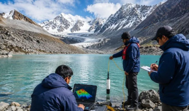
To quantify the ice-melt rate and assess long-term climate dynamics, the expedition team deployed multiple specialized high-altitude research instruments.
Instrumentation Matrix
- Steam Ice-Core Drilling: Scientists used steam-driven drills to penetrate the dense glacial structure without causing mechanical fracturing.
- Differential GPS (DGPS): The team anchored five new scientific monitoring stakes at an elevation of nearly 17,000 feet, using high-precision DGPS to monitor surface velocity and spatial displacement over time.
- Automatic Weather Stations (AWS): These systems provide continuous, real-time measurements of local meteorological parameters like air temperature, solar radiation, and relative humidity directly on the glacier surface.
- Automatic Water Level Recorders (AWLR): Positioned downstream, these sensors monitor hourly changes in meltwater discharge volumes to help identify early signatures of anomalous glacial drainage.
| Parameter / Metric | Details of Khangri Glacier 2026 Findings |
| Geographic Location | Tawang District, Arunachal Pradesh, India |
| Mountain Range Section | Gori Chen (Gorichen) Range, Eastern Himalayas |
| Primary Catchment Basin | Mago Chu Basin (Brahmaputra Headwaters) |
| Proglacial Lake Elevation | Approximately 16,500 feet above sea level |
| Monitoring Stake Elevation | Approaching 17,000 feet above sea level |
| Collaborating Institutions | CESHS (Arunachal Pradesh), NCPOR (GoA), NERIST |
| NDMA Hazard Classification | Category-B for Potential Glacial Lake Outburst Flood |
IASPOINT Booster Facts for UPSC
- Proglacial Lake Mechanics: These lakes form directly in front of a retreating glacier terminal, typically dammed by unstable, unconsolidated loose rock and ice debris known as moraines. A structural failure of these loose moraine dams triggers a Glacial Lake Outburst Flood (GLOF).
- National Centre for Polar and Ocean Research (NCPOR): Established in 1998 as an autonomous research and development institution under the Ministry of Earth Sciences (MoES), Government of India. It serves as the nodal agency for India’s polar research programs in the Arctic, Antarctic, and Himalayan regions (the Third Pole).
- Centre for Earth Sciences and Himalayan Studies (CESHS): A specialized autonomous state-level research organization operating under the Government of Arunachal Pradesh, dedicated to documenting geo-hazards, climate impacts, and cryospheric changes in the Eastern Himalayas.
- The Third Pole Concept: The Hindu Kush Himalayan (HKH) region is globally recognized as the Earth’s “Third Pole” because it contains the largest concentration of freshwater ice outside the two polar circles, serving as the source for ten major Asian river systems.
- National Disaster Management Authority (NDMA) GLOF Guidelines: Under the National Disaster Management Plan, the NDMA classifies glacial lakes into risk categories based on volume, moraine stability, and downstream proximity to human settlements to help structure local Early Warning Systems (EWS).