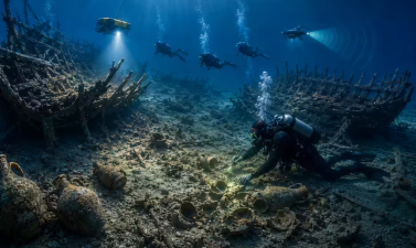
Archaeologists have discovered 151 underwater archaeological sites, including 134 shipwrecks, in the Bay of Gibraltar during excavations conducted between 2020 and 2023. This research, known as Project Herakles, was led by researchers from the University of Cádiz and the University of Granada. The findings document maritime vessels spanning over 2,400 years of history, dating from the 5th century BCE to World War Two. Located at the strategic junction of the Atlantic Ocean and the Mediterranean Sea, the Bay of Gibraltar has served as a vital maritime route, preserving fragile historical remains under unique underwater conditions.
Overview of Project Herakles
Project Herakles represents a major systematic underwater survey aimed at mapping the maritime heritage of the Gibraltar region.
Chronological Distribution of Shipwrecks
The survey cataloged 134 shipwrecks, revealing continuous naval activity across multiple historical epochs:
- Classical Antiquity: 23 Roman shipwrecks and various Punic-era remains.
- Medieval Period: 4 documented vessel remains from the Middle Ages.
- Early Modern Era: 24 ships belonging to major European maritime powers, including British, Spanish, Venetian, and Dutch vessels.
- Modern and Contemporary Era: Multiple vessels, including remnants of a 1930s military aircraft and World War Two artifacts.
Key Artifacts and Notable Finds
The underwater conditions in the bay helped preserve structural timbers, metallic components, and organic materials. A key discovery is the Puente Mayorga IV, an 18th-century Spanish gunboat. This vessel provides structural evidence of the naval technology used during regional conflicts and blockades in the late modern era. Additionally, the discovery of Punic and Roman amphorae helps trace ancient trade routes involving olive oil, wine, and garum (fish sauce).
Strategic Geography and Preservation Factors
The concentration of shipwrecks stems directly from the geographical importance of the region and specific marine environmental conditions.
Maritime Crossroads
The Bay of Gibraltar sits at the entrance of the Strait of Gibraltar. This narrow waterway is the sole natural link between the Atlantic Ocean and the Mediterranean Sea. For millennia, any trading vessel, military fleet, or migratory wave moving between Northern Europe, the Americas, Africa, and the Levant had to pass through or seek shelter in this bay.
Environmental Preservation
The sediment composition, water temperature, and low-oxygen pockets in certain zones of the Bay of Gibraltar prevent the rapid decay of organic matter. This allowed fragile components—such as the fuselage of the 1930s aircraft and the wooden hulls of ancient wooden ships—to remain intact instead of being destroyed by marine wood-boring organisms like shipworms.
Historical Evolution of Maritime Activity in the Bay
The discoveries map out distinct phases of geopolitical control and economic trade in the Mediterranean basin.
| Historical Era | Dominant Maritime Powers | Key Archeological Evidence found in the Bay |
| Punic & Roman Era (5th C. BCE – 5th C. CE) | Carthaginians, Romans | 23 shipwrecks, anchor stocks, transport amphorae, pottery fragments |
| Medieval Period (5th C. CE – 15th C. CE) | Byzantine, Islamic Caliphates, Castile | 4 shipwrecks, local ceramic cargo, early iron anchors |
| Early Modern Era (16th C. CE – 18th C. CE) | Spanish Empire, British Royal Navy, Dutch Republic, Venice | 24 warships and merchantmen, cannons, the Puente Mayorga IV gunboat |
| Modern Era (19th C. CE – 20th C. CE) | Global industrial nations, Allied and Axis powers | Steamship components, 1930s aircraft debris, World War Two military hardware |
IASPOINT Booster Facts for UPSC
- Punic Era Context: The Punic people, or Carthaginians, were western Phoenicians based in North Africa (modern-day Tunisia). They controlled western Mediterranean trade networks before losing dominance to Rome during the Punic Wars (264 BCE–146 BCE).
- The Pillars of Heracles: In classical antiquity, the Rock of Gibraltar was known as Mons Calpe, which along with Mons Abila (in North Africa) formed the Pillars of Heracles. This marked the boundary of the known maritime world for ancient Mediterranean sailors.
- Strait of Gibraltar Chokepoint: It is one of the world’s most critical maritime chokepoints. It is approximately 14 kilometers wide at its narrowest point, separating Europe (Spain/Gibraltar) from Africa (Morocco).
- Amphorae as Economic Indicators: In marine archaeology, amphorae serve as standardized ceramic containers. Analyzing their clay composition (petrography) allows historians to pinpoint the exact origin of production, helping map ancient global supply chains.