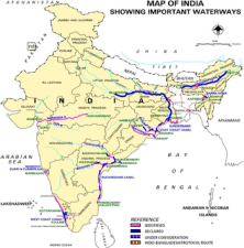
National Waterways of India

Cruise Shipping To promote the growth of Cruise Shipping, an inter-Ministerial Steering Committee with Secretary (Shipping) as Chairman has been constituted in June, 2010 to address the issues relating to development of cruise shipping. The Steering Committee has identified five ports, namely, Mumbai, Goa, Chennai, Mangalore and Cochin for development of Cruise tourism. Sethusamudram Ship Channel Project To ensure that vessels moving between eastern and western coasts of India could have a continuous navigable route within India’s own territorial waters, the implementation of Sethusamudram Ship Channel Project envisaging cutting of a channel to connect the Gulf of Mannar and Bay of Bengal through Palk Strait and Palk Bay is under way. National Waterways of India
| Waterways | Stretch | Specication | Year of |
| | | declaration |
| | | |
| NW 1 | Allahabad-Haldia | It is one of the most important waterways in | 1986 |
| Stretch (1,620 km) | India, which is navigable by mechanical boats | |
| | up to Patna and by ordinary boats up to | |
| | Haridwar. It is divided into three parts for | |
| | developmental purposes ‘ (i) Haldia-Farakka | |
| | (560 km), (ii) Farakka-Patna (460 km), | |
| | (iii) Patna-Allahabad (600 km). | |
| NW 2 | Sadiya-Dhubri stretch | Brahmaputra is navigable by steamers up to | 1988 |
| (891 km) | Dibrugarh (1,384 km) which is shared by India | |
| | and Bangladesh. | |
| NW 3 | Kottapuram-Kollam | It includes 168 km of west coast canal along | 1991 |
| Stretch (205 km) | with Champakara canal (23 km) and | |
| | Udyogmandal canal (14 km). | |
| | | Indian and World Geography 159 |
| NW 4 | Kakinada | Stretch of canal and Kalurelly Tank stretches | 2008 |
| Puduchery (1995 km) | of river Godavari and Krishna. | |
| NW 5 | Talcher Dhamra | Stretch of river Brahmani Geonkhali Cherlatia | 2008 |
| (623 km) | stretch of East coast canal, Chertectia Dharma, | |
| | Stretch of Matai river alongwith Mahanadi delta | |
| | | | |
The dredging in Adams Bridge region has been stopped in view of the Honrble Supreme Court order. Pursuant to orders of the Honrble Supreme Court, a Committee of Experts has been constituted under the Chairmanship of Dr. R.K. Pachauri, to consider the alternative alignment in respect of the Sethusamudarm Ship Channel Project. Based on the recommendation of the Expert Committee, National Institute of Oceanography (NIO), Goa has been assigned the task of undertaking Environment Impact Assessment (EIA) of the proposed alternative alignment. The NIO has alized its report which is under consideration of the Expert Committee. Saving of distance through the proposed Sethusamudarm Ship Channel Project (Nautical miles)
| From | To | Distance through | Distance through | Saving of |
| | present route | proposed route | Distance |
| | | | |
| Kanniyakumari | Chennai | 750 | 407 | 343 |
| Kanniyakumari | Vishakhapatnam | 1014 | 724 | 290 |
| Kanniyakumari | Kolkata | 1357 | 1103 | 254 |
| Tuticorin | Chennai | 759 | 345 | 414 |
| Tuticorin | Vishakhapatnam | 1028 | 662 | 366 |
| Tuticorin | Kolkata | 1371 | 1041 | 330 |
| | | | |
Last Modified: April 16, 2026