A major submarine volcanic eruption began on May 8, 2026, in the Central Bismarck Sea, north of Papua New Guinea. The eruption occurred along an underwater volcanic formation called Titan Ridge, located roughly 16 kilometers southeast of a historical 1972 eruption site. The sudden geological event has highlighted a major gap in modern oceanography: the deep ocean floor remains mapped at a much lower resolution than the surfaces of the Moon and Mars. Multiple space agency satellites are monitoring the area as scientists track the active underwater vents for signs that a new island might emerge above the Pacific Ocean surface.
Tectonic and Geographic Setting
Regional Geology
The Bismarck Sea sits within the Pacific Ring of Fire, characterized by intense seismic and volcanic activity. The current eruption site is situated along the Bismarck Sea Seismic Lineation. This zone marks a complex boundary where tectonic microplates interact, primarily involving the North Bismarck and South Bismarck microplates.
Seafloor Spreading Mechanics
The tectonic activity is driven by the opening of the Manus Basin. This back-arc basin features a high seafloor spreading rate of roughly 137 millimeters per year. The eruption along Titan Ridge is structurally linked to the intersection of an active transform fault and this rapidly growing back-arc spreading center.
Eruption Characteristics and Satellite Monitoring
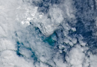
Detection and Physical Signatures
The eruption followed a localized swarm of six earthquakes on May 8, 2026. Because high-resolution bathymetric maps of the deep seafloor were unavailable, scientists relied on a fleet of earth-observation satellites to evaluate the ongoing activity. The physical signs detected include:
- Steam and Ash Plumes: White, steam-rich plumes and ash clouds have repeatedly risen several kilometers into the atmosphere, tracked by the Darwin Volcanic Ash Advisory Centre.
- Thermal Anomalies: Instruments detected a distinct thermal footprint spanning roughly seven square kilometers. This strong infrared signal indicates that hot magma is located very close to the ocean surface, meaning the active vent is shallower than the hundreds of meters of depth indicated on old maps.
- Discolored Water: Plankton and ocean-color sensors mapped a large zone of green, chemically disturbed water stretching several kilometers southwest due to regional ocean currents.
- Pumice Rafts: Volcanic ejections produced extensive floating fields of porous, glassy volcanic rock known as pumice.
Satellite Fleet Deployment
A coordinated group of international satellites is monitoring the active site to evaluate the threat of localized tsunamis and map the growing underwater structure:
| Satellite / Sensor | Operating Agency | Specific Monitoring Role |
| Landsat 9 (OLI) | NASA / USGS | Captured high-resolution natural and false-color views of the growing underwater volcanic platform. |
| Sentinel-2 | European Space Agency (ESA) | Tracked surface changes, plume extensions, and near-surface thermal energy. |
| Terra & Aqua (MODIS) | NASA | Monitored wide-area optical imagery of the steam plumes and drifting pumice rafts. |
| PACE | NASA | Used specialized ocean-color sensors to trace the extent of chemically discolored and disturbed water. |
| Suomi NPP (VIIRS) | NASA / NOAA | Detected and measured the seven-square-kilometer thermal anomaly using infrared bands. |
| NISAR | NASA / ISRO | Joint radar mission capable of tracking surface deformation and checking for new land mass creation. |
| RADARSAT | Canadian Space Agency | Provides synthetic aperture radar imaging to observe the ocean surface irrespective of cloud cover. |
Ecological and Island-Forming Potential
Island Birth Dynamics
If the explosive underwater activity continues, accumulation of basaltic debris and cooling lava could build a stable tuff cone. Volcanologists are watching to see if this structure breaks the ocean surface to form a permanent island. Alternatively, the structure could face rapid marine erosion or collapse back into the magma chamber.
Primary Ecological Succession
The formation of a brand-new volcanic island creates an isolated, sterile landmass. This environment gives scientists a rare, clean slate to observe how life naturally colonizes new land over time, tracking:
- Microbial Colonization: The initial settlement of extremophile bacteria and blue-green algae that survive on bare, mineral-rich volcanic rock.
- Pioneer Plant Species: The arrival of hardy, wind-borne ferns, mosses, or coastal plants brought by ocean currents.
- Animal Introduction: The arrival of seabirds, which use the isolated island for nesting and drop nutrients that help develop early soils.
IASPOINT Booster Facts for UPSC
- Pacific Ring of Fire: A 40,000-kilometer horseshoe-shaped belt associated with a continuous series of oceanic trenches, volcanic arcs, and plate movements. It contains over 75 percent of the world’s active and dormant volcanoes.
- Back-Arc Basins: Submarine basins formed behind volcanic island arcs due to tectonic extension and rifting. They are prime locations for hydrothermal vents and unique deep-sea ecosystems.
- Pumice: An igneous volcanic rock formed when highly pressurized, gas-rich magma is violently ejected. The rapid cooling traps gas bubbles inside, creating a sponge-like texture with a low density that allows it to float on water.
- NISAR Mission: The NASA-ISRO Synthetic Aperture Radar is a dual-frequency (L-band and S-band) radar satellite designed to map global land and ice surface reformations every 12 days, helping study natural hazards and ecosystem disturbances.
- Bathymetry: The measurement and study of the depth of water in oceans, seas, or lakes. While space-based radar can map planetary surfaces perfectly, mapping the deep ocean floor relies on ship-based acoustic sonar systems, leaving large portions of the global seabed unmapped at high resolution.