The Directorate General of Hydrocarbons (DGH), under the Ministry of Petroleum and Natural Gas, initiated an extensive offshore geophysical survey program mapping over 161,000 line kilometers across the Bay of Bengal and adjoining basins. The two-year project utilizes two-dimensional broadband marine seismic, gravity, and magnetic data acquisition, processing, and interpretation to identify domestic oil and natural gas reserves. This state-funded exploration drive aims to enhance domestic energy production, improve data availability in untapped maritime zones, and reduce reliance on crude oil imports, which account for nearly 89% of national crude requirements.
Geographical Scope and Target Basins
The survey spans key sedimentary basins along the east coast, west coast, and frontier offshore regions.
- East Coast Basins: It covers the Bengal-Purnea, Mahanadi, Krishna-Godavari, and Cauvery offshore areas. The Krishna-Godavari Basin and the wider Bay of Bengal remain critical petroleum provinces for national energy security.
- West Coast Basins: The survey extends to the Saurashtra offshore basin to evaluate deepwater and shallow-water prospects.
- Frontier Offshore Region: Exploration targets the Andaman Basin, a frontier zone with high hydrocarbon potential sharing geological features with natural gas-producing fields in Myanmar and Indonesia.
Exploration Technologies and Methodologies
The DGH exploration program deploys multiple geoscientific mapping techniques to build detailed subsurface profiles.
Marine Seismic Surveys
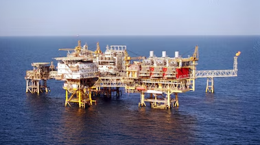
Seismic survey vessels project artificial sound waves into the ocean. These waves travel through the water column and penetrate subsurface rock layers. The acoustic signals reflect back at varying speeds based on rock density and fluid content. Hydrophones towed behind the vessel record the returning waves, allowing geophysicists to map geological formations and detect structural traps holding oil or gas.
Gravity and Magnetic Surveys
Gravity surveys measure minute variations in the gravitational pull of the Earth caused by differences in underground rock density. Magnetic surveys detect changes in the magnetic properties of subsurface rocks, particularly sedimentary basements. Combined with seismic data, these methods identify basins and thick sedimentary accumulations favorable for hydrocarbon generation.
Stratigraphic Drilling
Oil India Limited (OIL) and the Oil and Natural Gas Corporation (ONGC) are executing a parallel stratigraphic drilling campaign. This involves drilling specialized, non-productive wells to extract deep-sea rock core samples. The primary goal is data collection from completely unexplored basins before commencing full-scale commercial production drilling.
Policy Framework and Regulatory Drivers
The exploration push aligns with systemic shifts in the upstream energy administration sector.
The “Samudra Manthan” Programme
The central government is financing data collection in deepwater and ultra-deepwater blocks under the Samudra Manthan initiative. Direct state funding addresses private sector reluctance to absorb the high capital risks associated with initial deep-sea data acquisition.
Unlocking “No-Go” Zones
In 2022, the government lifted commercial exploration restrictions on nearly one million square kilometers of offshore areas. These zones were previously off-limits due to defense, space, environmental, or strategic considerations. The ongoing survey focuses on gathering baseline data in these newly opened maritime territories to attract global investment.
Licensing Frameworks
Offshore blocks are administered under the Hydrocarbon Exploration and Licensing Policy (HELP), which features a single license for all hydrocarbon types and a revenue-sharing model. Under the Open Acreage Licensing Programme (OALP), operators continuously submit Expressions of Interest (EoIs) for available blocks, which are subsequently offered via international competitive bidding rounds.
| Exploration Parameter | Details and Metric Specifications |
| Nodal Implementing Agency | Directorate General of Hydrocarbons (DGH) |
| Total Survey Area Scope | Over 161,000 line kilometers |
| Project Duration | 2 Years |
| Primary Data Types | 2D Broadband Seismic, Gravity, and Magnetic Data |
| Core Administrative Policy | Hydrocarbon Exploration and Licensing Policy (HELP) |
| Strategic Funding Initiative | Samudra Manthan Programme |
IASPOINT Booster Facts for UPSC
- Technical Upstream Regulator: The DGH was established in 1993 via a government resolution to manage oil and gas resources with regards to environment, safety, and economic aspects. It monitors Production Sharing Contracts (PSCs) and executes OALP bidding rounds.
- Hydrocarbon Basin Classification: India has 26 sedimentary basins divided into three categories based on maturity. Category-I basins possess commercial production (e.g., Krishna-Godavari, Mumbai Offshore, Cambay). Category-II basins have known accumulation but no commercial production yet. Category-III basins have prospective resources with uncertain commerciality (e.g., Andaman, Bengal, Saurashtra).
- HELP vs NELP: HELP replaced the New Exploration Licensing Policy (NELP) in 2016. NELP operated on a profit-sharing model that led to disputes over cost recovery. HELP transitioned the sector to a revenue-sharing mechanism with open acreage selection and marketing freedom for extracted gases.
- National Data Repository (NDR): The DGH hosts the NDR, a centralized database storing all geoscientific data from Indian sedimentary basins. The data generated from the current 161,000 line-kilometer survey will populate the NDR to lower data-access barriers for international exploration firms.