Geologists have mapped extensive subsurface networks beneath Africa that reveal the continent’s complex tectonic and mantle dynamics. These discoveries focus heavily on the East African Rift System (EARS), a developing divergent plate boundary where the African Plate is actively splitting into the Nubian and Somali microplates. Advanced imaging and geochemical analyses have isolated major structural features, including deep magma networks, an ancient transform margin, and deep-seated mantle fluids. These interconnected systems are driven by the African Superplume, directly influencing continental breakup and the eventual formation of a new ocean basin.
Structural Segmentation and Tectonic Dynamics
The East African Rift System extends over 6,400 kilometers from the Jordan Valley in southwestern Asia down to Mozambique. The rift architecture comprises two primary structural branches segmented by localized microplates.
The Eastern Rift Valley
Also known as the Gregory Rift, this branch runs south from the Afar Triple Junction through the Main Ethiopian Rift and Kenya into northern Tanzania. It is characterized by high volcanic activity, lithospheric thinning, and the accumulation of subterranean magma sills.
The Western Rift Valley
The Albertine Rift forms the western branch, curving through Uganda, Rwanda, Burundi, the Democratic Republic of the Congo, and Zambia before terminating in Mozambique. This branch features deep, elongated graben basins that contain Africa’s largest deep-water lakes, including Lake Tanganyika and Lake Malawi.
Microplate Micro-Rotation
The mechanical separation of the continent is not uniform. The rifting process isolates smaller lithospheric blocks, notably the Victoria microplate in the north and the Rovuma and Lwandle microplates in the south. The Victoria microplate undergoes a distinct counter-clockwise rotation relative to the larger Nubian Plate, altering local strain distribution along the rift shoulders.
| Tectonic Component | Geographic Scope | Geological Characteristics |
| Nubian Plate | Western and major portion of Africa | Stable continental cratonic core |
| Somali Plate | Eastern coast of Africa and Madagascar | Moving eastward away from the main continent |
| Victoria Microplate | Enclosed between Eastern and Western branches | Rotating counter-clockwise; drives localized compression |
| Rovuma Microplate | Southern section near Mozambique and Tanzania | Bounded by newly discovered ancient transform systems |
Key Deep-Subsurface Discoveries
Recent geophysical and geochemical surveys have illuminated hidden structural anomalies beneath the East African crust, linking surface rifting to deep-mantle anomalies.
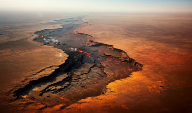
Magma Sills beneath the Afar Depression
Geophysical imaging within the Afar region reveals an extensive network of horizontal magma sills stored within the thinned continental crust. The Afar Depression forms a triple junction where the Red Sea, the Gulf of Aden, and the EARS converge. The injection of these subsurface magmatic sheets chemically weakens the lithosphere, accelerating tectonic extension and transition into a marine spreading center.
The Rovuma Transform Margin
Scientists have identified a 500-kilometer-long buried fault system running beneath the coastal regions of Mozambique and Tanzania. Named the Rovuma Transform Margin, this structural feature dates back 180 million years to the initial fragmentation of the supercontinent Gondwana. Seismic sound waves and satellite gravity records show that the crust thins sharply by 18 miles across a narrow width of just 10.5 miles. This steep profile confirms that the ancient boundary was shaped by extreme horizontal shearing rather than gradual stretching.
Helium Isotope Signatures in the Kafue Rift
Geochemical sampling of hot springs within Zambia’s Kafue Rift has revealed anomalous ratios of helium-3 (3He) to helium-4 (4He). Because helium-3 is primordial and primarily trapped within the Earth’s interior, elevated concentrations indicate that deeply seated mantle fluids are rising directly from depths of 40 to 160 kilometers. This fluid migration utilizes the deeply penetrating fault systems of the Western Rift as conduits to the surface.
The African Superplume and Mantle Mechanics
The primary driver behind continental rifting across East Africa is the African Superplume, also known as the Large Low-Shear-Velocity Province (LLSVP) beneath Southwest Africa.
Mantle Upwelling and Thermal Uplift
The superplume represents a massive, buoyant upwelling of hot mantle rock rising from the core-mantle boundary. As this thermal anomaly impinges on the base of the African lithosphere, it causes massive dome-shaped thermal uplifts. This bottom-up heating stretches the overlying crust, generating tension fractures, normal fault networks, and extensive volcanic provinces.
Triple Junction Evolution
The ultimate manifestation of this plume-driven rifting is seen at the Afar Triple Junction. As the crust continues to pull apart at a rate of 8 to 9 millimeters per year, the rift valley floors drop below sea level. Over millions of years, this structural depression will allow the Red Sea and the Gulf of Aden to flood the deepening valley, effectively cutting off the Somali Plate and birthing a new global ocean basin.
IASPOINT Booster Facts for UPSC
- Aulacogen Status: The Main Ethiopian Rift can be geologically classified as an active aulacogen—a failed arm of a triple junction system. While the Red Sea and Gulf of Aden arms successfully transitioned to full seafloor spreading, the East African arm represents a slower, ongoing continental rifting stage.
- The Davie Fracture Zone: Prior to mapping the landward Rovuma Transform Margin, older tectonic models placed the Jurassic-era Gondwana separation boundary further offshore along the Davie Fracture Zone, a 2,200-kilometer seafloor relic running through the West Somali Basin.
- Volcanic Milestones: The intensive magmatism triggered by the African Superplume created Africa’s highest peaks, including Mount Kilimanjaro (a dormant stratovolcano) and Mount Kenya, along with hyper-active tracking zones like Ol Doinyo Lengai, famous for erupting unique carbonatite lava.
- Graben vs. Horst: The topography of the East African Rift is a classic textbook example of basin-and-range architecture. The dropped valley floor forms the graben, while the steeply elevated, parallel cliffs form the horst or rift shoulders.
- Ancient Suture Reactivation: The Cenozoic rifting of the EARS does not cut through random crust. The fault lines preferentially reactivate ancient, structural weak points or mobile belts formed during the Neoproterozoic East African Orogeny when Gondwana was first assembled.