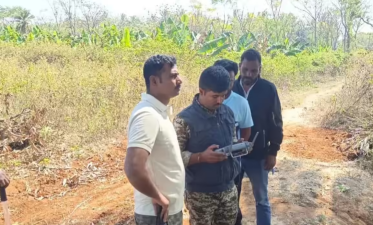
Forest departments in Karnataka, Arunachal Pradesh, and Tamil Nadu are increasingly deploying thermal drones equipped with infrared sensors for wildlife rescue and monitoring operations. This technology allows frontline staff to detect animals through heat signatures from distances of 5 to 6 kilometers, making night-time operations in dense forests possible. By combining infrared sensors with unmanned aerial systems, global positioning systems (GPS), and live video transmission, these drones track straying or injured wildlife. This recent technological shift addresses the challenge of monitoring animal movement near human settlements and mitigating human-wildlife conflict.
Core Technology of Thermal Imaging
Infrared Radiation and Heat Signatures
Thermal imaging technology works by recording infrared radiation emitted by all objects with a temperature above absolute zero. Every living animal radiates heat, which the specialized sensors on a drone capture as a distinct thermal signature. The sensor translates these infrared wavelengths into a visual map where warmer objects appear brighter against cooler surroundings. This process does not require ambient light, allowing operators to locate animals in complete darkness, dense fog, or heavy foliage.
Integration with Drone Ecosystems
The effectiveness of modern wildlife rescue relies on the integration of multiple technologies within a single unmanned aerial vehicle (UAV) platform.
- Thermal Sensors: Capture long-wave infrared light to identify heat differentials.
- Optical Cameras: Provide high-resolution visual confirmation during daylight hours.
- GPS Modules: Record precise geographical coordinates of the detected animal in real time.
- Telemetry Links: Transmit live video feeds and location data directly to handheld base stations used by rescue teams on the ground.
State-Level Deployments and Applications in India
Arunachal Pradesh
The state forest department deployed five high-end thermal drones across critical conservation zones, focusing heavily on Namdapha National Park and Tiger Reserve. Due to the dense canopy cover and rugged terrain of the Eastern Himalayas, manual tracking is hazardous and slow. The state combines hardware deployment with structured training programs for frontline forest guards to ensure effective operations.
Karnataka
Karnataka utilizes thermal drones primarily for large mammal rescue operations and security enforcement. The Bandipur Tiger Reserve and surrounding conflict zones use these aerial assets to track elephants that stray into agricultural fields. The technology also tracks injured tigers and monitors anti-poaching camps, allowing forest guards to detect human intruders inside protected areas at night.
Tamil Nadu
The Tamil Nadu Forest Department employs thermal imaging to manage human-elephant conflict hotspots, particularly in the Coimbatore and Hosur divisions. Drones monitor the movement of elephant herds near forest fringes, allowing authorities to warn local communities and guide the animals back into the forest before accidental encounters occur.
Key Advantages in Wildlife Management
Night-Time Operations and Visibility
Traditional search and rescue operations halt or become dangerous after sunset. Thermal drones remove this limitation by providing clear visibility in zero-light conditions. They bridge the gap in low-visibility environments like the dense elephant grass of northern India or the multi-tiered rainforest canopies of the south.
Enhanced Real-Time Observation
Rescue teams receive live information regarding an animal’s exact position, speed, and direction of movement. This accurate data prevents rescue teams from accidentally cornering a stressed or dangerous animal, lowering the risk of injury to both the wildlife and the forest personnel.
Conflict Mitigation and Anti-Poaching
By identifying animals before they enter human habitations, forest departments can take preemptive action. The same thermal sensors expose poachers hiding in darkness, making forest surveillance more effective without requiring a massive increase in ground patrols.
Technical Specifications and Operational Parameters
| Parameter | Operational Capability |
| Detection Range | 5 to 6 kilometers under optimal atmospheric conditions |
| Spectral Range | 8 to 14 micrometers (Long-Wave Infrared) |
| Core Components | Infrared sensor, GPS module, daylight payload, live telemetry transmitter |
| Primary Terrains | Tropical rainforests, alpine meadows, tall grasslands, fringe agricultural lands |
| Target Species | Asian Elephant, Bengal Tiger, Indian Leopard, one-horned rhinoceros |
IASPOINT Booster Facts for UPSC
- Namdapha National Park: Located in Arunachal Pradesh, it is the only national park in India that harbors four big cat species: Tiger, Leopard, Snow Leopard, and Clouded Leopard. It also hosts the endangered Hoolock Gibbon, India’s only ape.
- Bandipur Tiger Reserve: Situated at the tri-junction of Karnataka, Tamil Nadu, and Kerala, it forms a crucial part of the Nilgiri Biosphere Reserve. It shares borders with Nagarahole National Park, Mudumalai Wildlife Sanctuary, and Wayanad Wildlife Sanctuary.
- Thermoregulation Fact: Thermal imaging struggles when the ambient environmental temperature matches the body temperature of the animal (thermal camouflage). This makes early morning and late-night hours the best times for thermal drone operations.
- Legal Framework: The deployment of drones by forest departments must comply with the guidelines issued by the Directorate General of Civil Aviation (DGCA) under the Drone Rules, 2021, which categorize operational zones into Green, Yellow, and Red zones.
- Wildlife Protection Act, 1972: Species targeted for these high-tech rescue operations, such as the Bengal Tiger and Asian Elephant, are listed under Schedule I of this Act, granting them the highest level of legal protection in India.