Tropical storm Nokaen, locally called Ada, is moving slowly northward over the Philippine Sea and is expected to affect the eastern coast of southern Luzon in the Philippines. Authorities have warned that the storm may bring heavy to intense rainfall around Mayon Volcano in Albay province, raising the risk of lahars and muddy streamflows in surrounding river channels and drainage systems.
Storm Intensity and Track
PAGASA said Nokaen has maximum sustained winds of 65 kilometres per hour near the centre, with gusts reaching 80 kilometres per hour. The system is located east of Eastern Visayas and is being monitored as the first tropical cyclone of the year. Its projected path suggests rainfall over parts of southern Luzon this weekend.
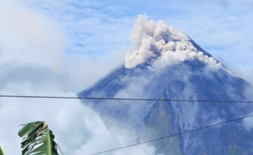
Lahar Risk Around Mayon
Phivolcs warned that rainfall of 100 to 200 millimetres could trigger volcanic sediment flows around Mayon Volcano. These lahars may form when loose volcanic material is carried into river channels by heavy rain. The agency said fresh deposits from the volcano’s ongoing eruption could mix with water and create syn-eruption lahars on the southern and eastern slopes.
Hazards to Communities
Officials cautioned that hot lahars may cause burns on contact and can lead to severe injuries. Older eruption deposits on the southwestern slopes may also be remobilised as non-eruption lahars. These flows can bury homes, damage roads, and affect downstream and coastal communities. Thousands of residents near Mayon have already been displaced by volcanic activity, and further rain may worsen conditions in evacuation centres.
Preparedness and Monitoring
Residents in affected areas have been urged to stay alert and follow official advisories. Emergency teams are monitoring both the storm and volcanic conditions closely. Heavy rain could complicate rescue operations and increase the risk of inundation, boulder impacts, and washouts in vulnerable settlements.
Last Modified: April 27, 2026