The Forest Survey of India has paused its Anavaran deforestation alert system, which had been sending fortnightly, location-specific alerts to states using satellite imagery and machine learning. The portal was designed to support near-real-time monitoring of forest loss and enable targeted field inspections. Its data have not been updated since November 2025, and active alerts reportedly stopped in January.
What Anavaran Did
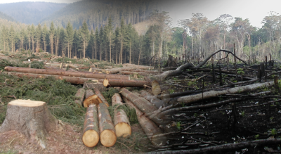
Anavaran was developed as a digital monitoring tool for detecting forest cover loss across India. It used satellite inputs and algorithm-based comparison of images to identify unusual changes in forest patches. Alerts were then sent to state forest departments with precise coordinates for verification on the ground.
Technology Used
The system was built on the Google Earth Engine platform. It used Sentinel-2 optical satellite images and Sentinel-1 Synthetic Aperture Radar data for continuous monitoring, including during cloudy and monsoon periods. Historical seasonal data were used as a baseline, and deviations were flagged by the algorithm. The system was intended to improve the speed and accuracy of deforestation detection.
Scale and State-Level Alerts
Between January 2024 and October 2025, the system generated 12,351 alerts. The monthly average rose sharply during the November-March period, when manmade deforestation generally increases. Punjab, Andhra Pradesh and Arunachal Pradesh recorded the highest number of alerts, followed by Nagaland, Manipur, Uttarakhand, Assam, Tripura, Maharashtra, Mizoram, Gujarat and Karnataka.
Why It Matters
Anavaran was seen as a major step in using remote sensing and artificial intelligence for forest governance. It was compared with earlier deforestation alert systems used in Latin America, but with finer spatial resolution and more frequent alerts. The pause has raised concerns about continuity in real-time forest monitoring, even as FSI continues to run its forest fire alert systems through the Van Agni and Sachet platforms.
Last Modified: April 28, 2026