
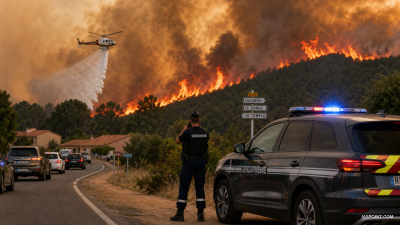
Wildfires in south‑western France and central Spain on 24 July 2026 forced mass evacuations and led both governments to request assistance from the European Union; combined evacuees exceeded 80,000.
Key locations and impact
- France — Cap Ferret, Gironde: fire burned >12,500 ha (≈125 km2); >44,000 people evacuated; 53 homes and one campsite damaged; 42 firefighters injured; Gironde is a department in Nouvelle‑Aquitaine (prefecture: Bordeaux).
- Spain — Madrid & Ávila region: two large blazes merged near Madrid with a third threatening to join; ~20,000 evacuated; Spain declared its first national emergency for a wildfire on 24 July 2026.
Fire types and drivers
- Wildfire: uncontrolled combustion spreading through vegetation; risk escalates in the wildland‑urban interface (WUI) where settlements meet flammable fuels.
- Meteorological drivers: Mediterranean summer pattern — high temperatures, low humidity, dry fuels and strong winds — increases ignition probability and spread rate.
Monitoring and response mechanisms
- EU Civil Protection Mechanism: coordinates cross‑border requests and deployment of aircraft, crews and logistics among member states.
- rescEU & Copernicus EMS/EFFIS: rescEU holds strategic aerial firefighting assets; Copernicus Emergency Management Service and EFFIS supply satellite mapping, fire danger indices and burned‑area estimates.
IASPOINT Booster Facts
- Area conversion: 1 ha = 0.01 km2; 12,500 ha = 125 km2.
- Administrative linkages: Ávila belongs to Castile and León; Community of Madrid is one of Spain’s 17 autonomous communities.
- EFFIS operator: European Commission Joint Research Centre provides near‑real‑time fire radiative power and historic fire datasets.