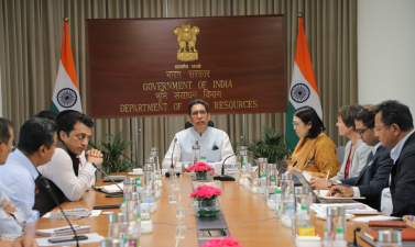
The Department of Land Resources (DoLR) under the Ministry of Rural Development recently held high-level discussions with the Asian Development Bank (ADB) to explore collaborative avenues in digital land governance and watershed management. During the meeting, central officials presented India’s major ongoing land reforms, focusing on the progress of the Digital India Land Records Modernization Programme (DILRMP) and the generation of Unique Land Parcel Identification Numbers (ULPIN), also known as Bhu-Aadhaar. The DoLR highlighted the upcoming launch of ‘DILRMP 3.0’ and the creation of an integrated digital ‘Land Stack’ designed to streamline land administration. ADB representatives expressed keen interest in backing these initiatives through multi-year technical assistance, institutional capacity building, and innovative financing mechanisms for climate-resilient rural development. PIB
Institutional Framework and Modernization Programmes
Digital India Land Records Modernization Programme (DILRMP)
- Genesis: Launched in 2008 as a Central Sector Scheme by merging two earlier programs: the Computerisation of Land Records (CLR) and the Strengthening of Revenue Administration and Updating of Land Records (SRA & ULR). BYJU’S
- Funding Pattern: The central government provides 100% financial assistance to States and Union Territories for implementation since the fiscal year 2016–17. Press Release:Press Information Bureau
- Core Objective: To transition from the traditional presumptive title system to a conclusive land titling system with institutional state guarantees. BYJU’S
- Administrative Unit: The district serves as the primary unit of implementation for planning, financing, and monitoring the digitisation process.
Evolution into DILRMP 3.0
- Scope Expansion: Following near-saturation of basic digitisation under previous iterations, DILRMP 3.0 focuses on the dynamic, real-time updating of land records rather than static data entry. PIB
- Integration Focus: The current phase links land records databases directly with revenue courts, registration departments, and banking systems.
- Urban Extension: The department introduced the NAKSHA (National Geospatial Knowledge-based Land Survey of Urban Habitations) pilot project across 150 selected cities to map complex urban land properties. Press Release:Press Information Bureau
Technical Architecture of ULPIN (Bhu-Aadhaar)
Operational Identification Mechanics
- Code Structure: ULPIN is a unique 14-digit alphanumeric identification number allocated to individual land parcels. Testbook
- Spatial Basis: The identification operates strictly on the longitudinal and latitudinal coordinates of the land parcel, relying on electronic total station surveys and geo-referenced cadastral maps. Testbook
- Developer: The national technical framework and software infrastructure for ULPIN are conceptualized and built by the National Informatics Centre (NIC). Wikipedia
- Current Penetration: Over 66% of agricultural land parcels across India have successfully received a distinct ULPIN, translating to more than 32 crore generated records. PIB
Key Components of a Digital Land Record Profile
- Spatial coordinates mapping the exact geometric boundaries of the plot. Ujjivan Small Finance Bank
- Clear records of current and historical ownership rights (Record of Rights). Department of Land Resources
- Notated land-use classifications, taxation valuations, and historical encumbrances. Testbook
The Integrated Land Stack and Socio-Economic Impact
Eliminating Departmental Redundancy
Land governance in India traditionally suffers from administrative overlap across multiple distinct authorities. The digital Land Stack unifies these separate layers into a single interoperable interface: PIB
| Department | Traditional Responsibility | Digital Stack Solution |
|---|---|---|
| Registration Department | Deeds registration under Registration Act, 1908 | Electronic deed filing linked directly to ULPIN |
| State Revenue Department | Maintenance of textual Records of Rights (RoR) | Automatic, real-time mutations upon sale |
| Land Survey Department | Preparation of field and cadastral maps | Geo-referenced GIS mapping linked to ownership |
| Forest & Municipal Bodies | Administration of public lands and property taxes | Instant boundary cross-verification to halt encroachment |
Economic Benefits and Financial Linkages
- Litigation Reduction: Land disputes account for roughly 66% of all civil suits in Indian courts, with average pendency stretching over 20 years. Comprehensive digital tagging helps clear title ambiguities. BYJU’S
- Collateral Efficiency: Financial institutions use the ULPIN registry to verify land titles instantly for crop loans, mortgage processing, and agricultural credit disbursements. Ujjivan Small Finance Bank
- Cost-Effective Implementation: Assigning a unique ULPIN costs around ₹3 per record, making it a highly economical administrative intervention. BYJU’S
Watershed Management and Climate Resilience
Project Convergence
- Nodal Scheme: The Watershed Development Component of Pradhan Mantri Krishi Sinchayee Yojana (WDC-PMKSY 2.0) handles physical land restoration and water harvesting. Press Release:Press Information Bureau
- Data Synthesis: Integrating the digital Land Stack with watershed planning allows planners to overlay soil health, slope data, and drainage maps directly over ownership boundaries.
- Target Outcomes: The initiative optimizes rainwater harvesting, restores degraded spring catchments, and introduces climate-resilient cropping patterns across rainfed regions.
IASPOINT Booster Facts for UPSC
- Constitutional Jurisdiction: Under the Seventh Schedule of the Constitution of India, ‘Land’ and ‘Land Revenue’ are placed under Entry 18 and Entry 45 of the State List (List II). However, ‘Stamp Duties and Registration’ falls under Entry 28 of the Concurrent List (List III), necessitating central-state legislative harmony through initiatives like DILRMP. IMPRI Impact and Policy Research Institute
- Presumptive vs. Conclusive Title: Current Indian laws only register the transaction of land (deeds registration) under the Registration Act of 1908, which acts as presumptive proof of ownership. Conclusive titling requires a constitutional shift where the state officially certifies and guarantees the title holder against any third-party claims. BYJU’S+ 1
- The Bhudhaar Pioneer: The nationwide ULPIN project is technically modeled after the ‘Bhudhaar’ initiative successfully pioneered by the State Government of Andhra Pradesh. Wikipedia
- The Two-Stage Assignment Rule: A ULPIN number is initially issued as a “Temporary Bhudhaar” based purely on textual data found within current Records of Rights. It converts into a “Permanent Bhudhaar” only after ground-level physical boundaries are verified and locked with geo-coordinates. Wikipedia
- ADB’s Institutional Status: The Asian Development Bank, established in 1966 and headquartered in Manila, Philippines, is modeled closely on the World Bank. Voting power within ADB is weighted based on capital subscriptions; Japan and the United States hold the highest shares, followed by China and India.