The National Centre for Sustainable Coastal Management (NCSCM) completed the documentation and physical verification of 23,404 wetlands out of 23,415 identified water bodies in Maharashtra in May 2026. This extensive administrative exercise establishes the framework for the formal notification of these ecological zones under the Wetlands (Conservation and Management) Rules. By conducting high-resolution satellite mapping and ground-truthing, the initiative transitions vulnerable, unnotified spaces into legally protected ecosystems, preventing commercial land reclamation, illegal debris dumping, and infrastructure encroachments across urban and rural districts.
Institutional Framework and Ground-Truthing Mechanism
The state government tasked the NCSCM, an autonomous institution operating under the Union Ministry of Environment, Forest and Climate Change (MoEFCC), to execute the verification under the guidelines of the National Wetlands Inventory and Assessment.
Ground-Truthing Process
Ground-truthing refers to the field-level physical verification of mapped sites to validate boundaries, ecological health, and current land-use patterns against baseline remote sensing data. This data validation prevents mapping errors before the final statutory notification is issued. Out of the 23,415 documented sites across the state, field verification remains active for only 11 remaining wetlands located within the Pune district.
Legal Catalysts
The mapping and verification process gained momentum following public interest litigation by environmental organizations like Vanashakti. Subsequent directives from the Supreme Court of India mandated that states and Union Territories complete wetland demarcation within a binding timeline to counter rapid degradation.
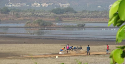
Spatial Distribution and District Statistics
The documentation revealed a high concentration of wetlands across distinct administrative divisions, particularly within the Chhatrapati Sambhaji Nagar and Nagpur divisions.
Top Performing Districts
Ahmednagar district contains the highest volume of individual wetlands in Maharashtra, followed closely by Nashik and Chandrapur.
Coastal and Urban Concentration
The inventory documented significant wetland presence across the high-growth zones of the Mumbai Metropolitan Region (MMR) and coastal belts, which remain highly vulnerable to urban infrastructure expansion:
- Ahmednagar: 1,596 wetlands
- Nashik: 1,236 wetlands
- Chandrapur: 1,231 wetlands
- Raigad: 1,093 wetlands
- Thane: 247 wetlands
- Mumbai Suburban: 210 wetlands
- Mumbai City: 37 wetlands
Statutory Regulations and Regulatory Enforcement
The formal notification brings these verified ecological zones under the ambit of the Wetlands (Conservation and Management) Rules, 2017, enacted under the Environment (Protection) Act, 1986.
Prohibited Activities
Once a wetland is officially notified by the State Wetland Authority, specific activities face strict statutory bans under Rule 4:
- Land reclamation and permanent conversion for non-wetland use.
- Setting up new industrial units or expanding existing hazardous facilities.
- Handling, manufacturing, storage, or disposal of hazardous substances.
- Solid waste dumping and discharge of untreated domestic or industrial effluents.
- Construction of permanent structures within the designated zone of influence.
Regulated and Permitted Activities
Activities aligned with the principle of “wise use”—which maintains the ecological character of the ecosystem—can be permitted with prior administrative approval. These include sustainable regional aquaculture, traditional small-scale agriculture, grazing, and specific eco-tourism infrastructure like temporary boat jetties.
| Administrative Authority | Primary Role | Legal Backdrop |
| National Centre for Sustainable Coastal Management (NCSCM) | Technical mapping, satellite documentation, and field ground-truthing. | Scientific body under MoEFCC. |
| State Wetland Authority (SWA) | Processing field maps, evaluating brief documents, and issuing statutory notifications. | Constituted under Wetlands Rules, 2017. |
| District Administration / Collectorates | Local boundary enforcement, monitoring encroachments, and preventing illegal debris dumping. | Executive enforcement arm. |
| Ministry of Environment, Forest and Climate Change (MoEFCC) | Central policymaking, international compliance, and final appellate authority. | Environment (Protection) Act, 1986. |
IASPOINT Booster Facts for UPSC
- National Wetland Atlas: The MoEFCC released the decadal-change version of the National Wetland Atlas in 2020 to map the spatial changes in India’s wetlands using satellite data.
- National Green Tribunal (NGT) Mandate: In March 2022, the NGT ruled that all wetlands measuring above 2.25 hectares must automatically receive protection under the operational clauses of Rule 4 of the Wetlands Rules, irrespective of formal notification status.
- Ramsar Network Status: India contains 99 designated Ramsar Sites (Wetlands of International Importance) as of 2026. Tamil Nadu holds the highest number of Ramsar sites in India with 20 designated locations.
- Wetland Definition Exclusions: Under the Wetlands Rules 2017, the legal definition of a wetland explicitly excludes river channels, paddy fields, human-made water bodies constructed specifically for commercial aquaculture, salt pans, and irrigation tanks.
- Ecological Value of Urban Wetlands: Unnotified coastal wetlands in regions like Uran function as natural drainage sponges. Delays in their statutory notification led to large-scale reclamation, causing severe unseasonal localized flooding in the Mumbai Metropolitan Region.
- Blue Carbon Sequestration: Coastal wetlands, including mangroves and salt marshes, sequester carbon at rates up to ten times higher per unit area than terrestrial tropical rainforests, locking carbon within waterlogged soils for centuries.