NASA launched an interactive online tool called “Your Name in Landsat” on 24 April 2026. The tool uses more than 50 years of Landsat satellite imagery to find landforms that resemble letters and spell names from space-based images.
Landsat Programme
The Landsat programme began in 1972 as a joint mission of NASA and the United States Geological Survey (USGS). It provides the longest continuous space-based record of Earth’s land surface.
Data Use And Applications
- Landsat data are used for land resource management, forest monitoring, climate change studies, urban growth analysis, and agricultural assessment.
- Landsat data are free and publicly accessible, and they contributed an estimated $25.6 billion to the United States economy in 2023.
- The programme is often described as a standard reference for Earth observation because it offers long-term, consistent land imaging.
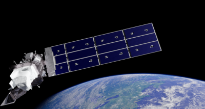
Active Satellites
Landsat 8 was launched on 11 February 2013, and Landsat 9 was launched on 27 September 2021. The two satellites observe the same location every 8 days when operated together, and they increase the volume of available data for researchers.
Landsat Next Mission
NASA is developing Landsat Next, a planned constellation of three identical observatories for launch in 2030 or 2031. The mission is designed to provide a 6-day revisit period and to generate about 15 times the data volume of Landsat 9.
- Landsat Next is planned with 15 new spectral bands, including 5 thermal infrared bands.
- The mission is intended to support monitoring of water use, soil conservation, and mineral mapping.
- The current individual Landsat repeat interval is 16 days.
Shanu
May 3, 2026 at 12:24 amShanu