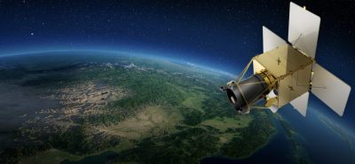
South Korea successfully launched its domestically developed Earth observation satellite, the Compact Advanced Satellite 500-2 (CAS500-2), on May 3, 2026. The satellite was carried into space by a SpaceX Falcon 9 rocket from the Vandenberg Space Force Base in California, United States. This mission marked a crucial shift in South Korea’s aerospace strategy, moving toward a commercial, industry-led satellite development model. The launch occurred after a four-year delay caused by geopolitical challenges that forced South Korea to shift its launch vehicle contract away from Russia.
Orbital and Technical Specifications
Orbit Profile
The CAS500-2 satellite was placed into a Sun-Synchronous Orbit (SSO). It operates at an altitude ranging between 498 kilometers and 528 kilometers above Earth. This specific orbital path ensures the satellite passes over any given point on the Earth’s surface at the same local mean solar time, providing constant lighting conditions ideal for optical imaging.
Payload and Imaging Capabilities
The 534-kilogram spacecraft carries advanced optical payload systems designed for high-precision remote sensing. Its specific imaging resolutions include:
- Panchromatic (Black-and-White) Imagery: 0.5-meter spatial resolution.
- Multispectral (Color) Imagery: 2.0-meter spatial resolution.
- Domestic Technology Integration: The satellite platform features 86 percent domestic components, while the core imaging payload achieves 98 percent domestic technological localization.
Ground Communication Architecture
Shortly after entering orbit, the satellite established normal telemetry and communication links. Initial tracking and data reception were validated through dual connectivity with polar and domestic ground infrastructure, specifically the Svalbard ground station in Norway and designated tracking facilities in South Korea.
Strategic Shifts and Industrialization
Transition to Private-Led ‘New Space’
The CAS500-2 program represents South Korea’s transition from government-funded research institutions to commercial defense and aerospace enterprises. Unlike its predecessor, CAS500-1, which was co-developed with the state-run Korea Aerospace Research Institute (KARI), the development and manufacturing of CAS500-2 was led entirely by a private entity, Korea Aerospace Industries (KAI), alongside domestic partners like Hanwha Systems.
Geopolitical Constraints and Launch Vendor Realignment
The satellite was originally scheduled for a 2022 liftoff aboard a Russian Soyuz rocket. Following Russia’s invasion of Ukraine and subsequent international sanctions, South Korea canceled the Russian launch contract. The mission was re-negotiated and transferred to SpaceX, utilizing a Falcon 9 booster that successfully completed its 33rd flight and recovered on a landing zone at Vandenberg.
Core Applications and Global Export Targets
Resource Governance and Disaster Mitigation
The primary operational roles of the CAS500-2 satellite focus on civilian management and emergency services.
| Operational Domain | Applied Functions |
| Land & Spatial Management | Urban planning, national cartography, and infrastructure development tracking. |
| Disaster Monitoring | Rapid imaging for response to forest fires, typhoons, and seasonal floods. |
| Primary Sector Tracking | Agricultural crop distribution monitoring and forestry resource surveying. |
Commercial Export Strategy
The South Korean government, via the Korea AeroSpace Administration (KASA), intends to market the standardized 500-kilogram satellite platform globally. The cost-competitive architecture is being actively positioned for export packages to countries looking to establish independent monitoring networks, with primary defense and technology export targets including Saudi Arabia, Peru, and Indonesia.
IASPOINT Booster Facts for UPSC
- Sun-Synchronous Orbit (SSO): A special type of low Earth polar orbit where the satellite maintains a constant orientation relative to the Sun. This consistency is essential for tracking seasonal environmental changes over time under identical shadow conditions.
- Korea AeroSpace Administration (KASA): Established recently as South Korea’s centralized space agency, modeled closely after NASA, to streamline space exploration, defense projects, and commercial satellite partnerships.
- Panchromatic vs. Multispectral Imagery: Panchromatic sensors collect light across a wide band of the visible spectrum into a single high-resolution black-and-white image. Multispectral sensors capture data across specific narrow wavelengths (red, green, blue, near-infrared), allowing computers to identify specific vegetation types and land-use patterns despite having a lower spatial resolution.
- Svalbard Satellite Station (SvalSat): Located in Norway, this is the world’s largest commercial ground station cluster. Its unique high-latitude polar location allows it to connect with low Earth orbit polar-orbiting satellites on every single rotation of the planet.