The Strait of Hormuz grabbed global attention in 2026 after Iran blocked this vital waterway following attacks by Israel and the United States. This narrow passage of just 20 nautical miles is crucial for oil and gas transport. The incident telld how geography continues to shape global politics, economy, and security. Despite technological progress, natural features like straits remain strategic chokepoints that influence human affairs.
Maritime Geographic Features and Their Importance
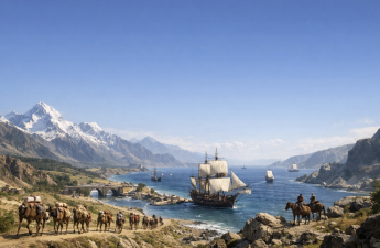
A strait is a narrow water passage connecting two large bodies of water. Examples include the Strait of Malacca, Taiwan Strait, and Strait of Gibraltar. These straits are vital for global trade and military strategy. Many have historic significance, such as the Battle of Tsushima Strait in 1905 and the Bosporus straits facilitating Russian and Ukrainian exports. Chokepoints like Hormuz and Bab-el-Mandeb can disrupt global supply chains when blocked. Isthmuses are narrow land strips connecting larger landmasses, such as the Isthmus of Panama and Suez. Humans have engineered canals here to shorten sea routes, like the Panama Canal and Suez Canal. These canals revolutionised global maritime transport by bypassing long and dangerous sea journeys.
Coastal Landforms – Peninsulas, Capes, and Bays
Peninsulas are land surrounded by water on three sides, such as the Indian Peninsula and Arabia. Capes mark changes in coastline direction, like Cape of Good Hope and Cape Horn, important for navigation during the Age of Sail. Bays and gulfs are sea inlets offering natural harbours. Examples include the Bay of Bengal and Gulf of Mexico, which supported the growth of major port cities like Mumbai and New York.
Land Features Shaping Civilisation
Rivers and plains nurtured early civilisations by providing water and fertile soil. Famous examples are the Indo-Gangetic Plain, Nile Valley, and Mesopotamia. Plateaus like the Ethiopian Highlands and Tibetan Plateau hosted early humans and preserved biodiversity. The Eurasian Steppe was a cradle for horse domestication, facilitating trade routes like the Silk Road and the rise of empires such as the Mongol Empire.
Human Interaction with Geography
Humans have adapted to and modified geography through canals, settlements, and trade routes. However, geography still imposes limits and shapes human activity. The relationship is dynamic, with neither humans nor geography having absolute control. Geography remains a fundamental factor in global affairs, security, and development.
Topics for Prelims:
Straits and Maritime Chokepoints
- Straits connect large bodies of water and serve as trade routes.
- Examples – Strait of Hormuz, Malacca, Gibraltar, Bosporus.
- Chokepoints can affect global oil and gas supply.
- Historical events linked to straits include naval battles and trade control.
- International Date Line passes through Bering Strait.
Isthmuses and Canals
- Isthmus is a narrow land bridge between landmasses.
- Panama and Suez are key isthmuses with canals.
- Canals shorten sea travel and boost trade.
- Panama Canal connects Atlantic and Pacific Oceans.
- Suez Canal connects Mediterranean and Red Seas.
Coastal and Landforms
- Peninsulas are land surrounded by water on three sides.
- Capes mark coastline direction changes, important for navigation.
- Bays and gulfs provide natural harbours for ports.
- Rivers and plains supported early agriculture and civilisations.
- Plateaus hosted early humans and preserved biodiversity.
Questions for Mains:
- Critically discuss the strategic importance of maritime chokepoints like the Strait of Hormuz and Strait of Malacca in global energy security. [GS-III-Internal & External Security]
- Examine the role of isthmuses and man-made canals in transforming global trade routes and their geopolitical implications. [GS-III-Economic Development]
- Analyse how physical geography such as rivers and plains influenced the rise of early civilisations and shaped human societies. [GS-I-Indian Culture]
- Estimate the challenges and opportunities in human attempts to modify geography through infrastructure projects like canals and ports, and their environmental impacts. [GS-III-Environment & DM]
Answer Hints:
1. Critically discuss the strategic importance of maritime chokepoints like the Strait of Hormuz and Strait of Malacca in global energy security. [GS-III-Internal & External Security]
- Straits are narrow passages connecting major water bodies, crucial for global oil and gas transport (Hormuz ~20 nautical miles wide; Malacca connects Indian & Pacific Oceans).
- Strait of Hormuz handles about 20-30% of global oil supply; Malacca is shortest route between Indian and Pacific Oceans with ~82,000 vessels annually.
- Blockades or disruptions (e.g., Iran blocking Hormuz in 2026) cause global energy shortages, price spikes, and geopolitical tensions.
- Both straits are ‘chokepoints’—control over them affects military strategy, trade security, and energy supply chains worldwide.
- Historical events (naval battles, conflicts) tell their strategic significance, e.g., Battle of Tsushima Strait, Russia-Ukraine exports via Bosporus).
- Dependence on these chokepoints makes global energy security vulnerable to regional conflicts and piracy.
2. Examine the role of isthmuses and man-made canals in transforming global trade routes and their geopolitical implications. [GS-III-Economic Development]
- Isthmuses are narrow land bridges connecting continents (e.g., Panama, Suez, Corinth); canals cut through them to connect seas, shortening sea routes.
- Suez Canal links Mediterranean and Red Seas, reducing travel time between Europe and Asia by bypassing Cape of Good Hope.
- Panama Canal connects Atlantic and Pacific Oceans, facilitating faster trade between US east and west coasts, and global maritime commerce.
- Canals have geopolitical importance – control influences global trade flow, regional power, and military mobility (e.g., Suez Crisis 1956).
- Man-made canals boost economic development, reduce shipping costs, and encourage intercontinental connectivity.
- They also create strategic chokepoints vulnerable to blockades and conflicts impacting global supply chains.
3. Analyse how physical geography such as rivers and plains influenced the rise of early civilisations and shaped human societies. [GS-I-Indian Culture]
- River valleys (Indo-Gangetic Plain, Nile, Mesopotamia, Yellow River) provided perennial water, fertile soil, and sediment for agriculture.
- Plains offered flat, fertile lands ideal for farming, settlement growth, and population expansion supporting kingdoms and empires.
- Access to water and fertile land enabled surplus food production, specialization of labor, and urbanization.
- Rivers facilitated trade, communication, cultural exchange, and political integration across regions.
- Plateaus (Ethiopian Highlands, Tibetan Plateau) hosted early humans and preserved biodiversity, influencing cultural development.
- Domestication of horses in Eurasian Steppe aided trade (Silk Road) and empire expansion (Mongol Empire).
4. Estimate the challenges and opportunities in human attempts to modify geography through infrastructure projects like canals and ports, and their environmental impacts. [GS-III-Environment & DM]
- Infrastructure projects like canals (Suez, Panama) and ports enhance trade, reduce travel time, and stimulate economic growth.
- Challenges include high costs, technical difficulties, geopolitical disputes, and vulnerability to blockades or sabotage.
- Environmental impacts – habitat destruction, changes in water salinity and flow, disruption of marine and terrestrial ecosystems.
- Canals can introduce invasive species, alter sediment transport, and increase pollution risks in connected seas.
- Climate change and rising sea levels pose risks to coastal infrastructure and necessitate adaptive management.
- Opportunities exist for sustainable engineering, environmental safeguards, and balancing development with ecological conservation.