Lake Kariba, the world’s largest man-made reservoir by volume located on the Zambia-Zimbabwe border, is experiencing a critical hydrological turnaround. After suffering prolonged droughts and intense heatwaves since the 2010s due to El Niño-induced weather patterns, the reservoir’s usable storage fell to a perilous 13% in 2024, causing severe regional power shortages, economic distress, and ecological imbalances. However, recent data from May 2026 reveals that improved rainfall across the upper Zambezi River catchment area has successfully revived water levels to over 42% of usable capacity. This hydrologic recovery offers vital relief for regional electricity grids, commercial fisheries, tourism operations, and riparian communities, though long-term climate vulnerabilities persist.
Geographical and Structural Profile of Lake Kariba
Location and Basin Characteristics
Lake Kariba is situated in Central-Southern Africa, positioned on the Zambezi River roughly halfway between the river’s source and its mouth, about 1,300 kilometers upstream from the Indian Ocean. It forms a natural boundary between Zambia (to the north) and Zimbabwe (to the south). The lake covers an expansive surface area of approximately 5,200 square kilometers, stretches over 220 kilometers in length, and reaches widths of up to 40 kilometers.
Engineering Framework
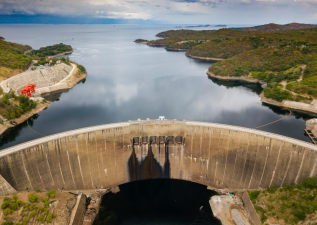
The reservoir was created between 1958 and 1963 following the construction of the Kariba Dam across the Kariba Gorge. The dam is a double-curved concrete arch structure standing 128 meters high and spanning 617 meters along its crest. The Zambezi River Authority (ZRA), a corporate body jointly owned by Zambia and Zimbabwe, manages the dam operations and hydrological data collection. The lake is designed to operate optimally between the water levels of 475.50 meters and 488.50 meters for sustained hydroelectric power generation.
Island Ecosystems
The reservoir contains 102 islands. Prominent among them are Spurwing Island and Chete Island. Chete Island contains the world’s largest expanse of protected, undeveloped lacustrine wetlands and supports a significant population of African elephants.
Drivers of the Hydroelectricity Crisis
Climate Change and El Niño Weather Anomalies
The primary driver of the prolonged crisis is the escalating frequency of severe droughts and extreme heatwaves across Southern Africa. The 2023–2024 El Niño cycle dramatically suppressed seasonal rainfall across the Zambezi River basin, reducing inflows to unprecedented historical lows.
Over-Allocation and Outdated Hydrological Modeling
Historically, operational water allocation formulas did not fully account for multi-year drought cycles. Continuous power generation demands from both riparian nations during periods of low inflows accelerated the depletion of the live storage volume.
Multi-Dimensional Impacts of the Crisis
Energy Security and Power Generation Economic Shock
The Kariba Hydroelectric Scheme features two primary power stations: the Kariba North Bank Power Station (Zambia) and the Kariba South Bank Power Station (Zimbabwe). When usable live storage dropped to 13% in 2024, power generation capacities were downscaled drastically. This caused rolling power cuts lasting up to 20 hours a day in both countries, disrupting manufacturing, mining activities, and domestic commerce.
Collapse of Commercial Fisheries
The lake supports a commercial fishing industry centered around the introduced Lake Tanganyika sardine, locally known as Kapenta (Limnothrissa miodon). Dropping water levels and rising water temperatures altered the thermocline dynamics, reducing nutrient upwelling, causing fish breeding failures, and lowering commercial catches.
Escalation of Human-Wildlife Conflicts
Shrinking shorelines forced wild animals from surrounding national parks to travel farther into human settlements in search of water. This resulted in a spike in human-wildlife conflicts, particularly involving crocodiles, hippopotamuses, and elephants.
Disruption of Tourism and Navigation
Low water levels exposed dangerous underwater hazards, restricted boat navigation, and grounded houseboats. This severely impacted the regional hospitality, safari, and sport-fishing tourism sectors centered around the Kariba basin.
The 2026 Hydrological Recovery
Upper Zambezi Catchment Inflows
Increased rainfall performance during the 2025–2026 wet season across the upper catchment areas—monitored closely at hydrometric key stations like Victoria Falls and Ngonye—boosted inflows.
Live Storage Regeneration
As of mid-May 2026, official hydrological records from the Zambezi River Authority confirm that the lake level has recovered steadily, reaching 481.41 meters. This brings the usable live storage to 42.40%, a stark contrast to the sub-15% levels recorded during the parallel periods of 2024 and 2025. This influx has normalized daily turbine discharge rates, stabilizing regional electricity supplies.
Strategic Roadmaps for Long-Term Climate Resilience
Regional Clean Energy Diversification
To reduce absolute dependence on the Zambezi River hydrology, water management authorities urge both nations to integrate alternative renewable energy options into their national grids. This includes developing floating solar photovoltaic (PV) systems directly on Lake Kariba’s surface to reduce water evaporation rates while generating power.
Integrated Catchment Management
Future policies emphasize combining modern satellite-derived meteorological forecasting with traditional ecological knowledge. Implementing strict demand-side water budgeting during early drought indicators can prevent deep storage depletion.
Economic Livelihood Diversification
Transitioning coastal communities away from an exclusive reliance on Kapenta fishing and standard tourism is critical. Promoting conservation agriculture, sustainable aquaculture cages, and off-grid solar-powered mini-grids will buffer local communities against future climate shocks.
Regional Hydrological Features of the Zambezi Basin
| Feature | Type / Description | Geopolitical Significance |
| Zambezi River | Fourth-longest river in Africa; flows into the Indian Ocean via the Mozambique Channel. | Primary hydrological lifeline for eight southern African nations. |
| Victoria Falls | Major natural waterfall located upstream of Lake Kariba. | Key hydrological monitoring station for predicting reservoir inflows. |
| Cahora Bassa | Large reservoir and hydroelectric dam downriver in Mozambique. | Second major cascade system on the Zambezi, directly impacted by Kariba’s outflows. |
| Chavuma & Ngonye | Upstream hydrometric stations on the Zambezi River. | Early-warning indicators for inflow volume tracking. |
IASPOINT Booster Facts for UPSC
- World’s Largest Reservoir: By water volume capacity (180 cubic kilometers), Lake Kariba is the largest artificial reservoir in the world. By surface area, Lake Volta in Ghana is larger.
- River Flow Direction: The Zambezi River flows eastward from its source in northwestern Zambia, moving through Angola, Zambia, Namibia, Botswana, Zimbabwe, and Mozambique before emptying into the Indian Ocean.
- Double-Arch Design: The Kariba Dam is a concrete double-arch dam. This specific design uses the natural curvature of the arch to transfer immense water pressure directly into the canyon walls.
- Operation Noah: During the filling of the lake between 1958 and 1964, a famous wildlife rescue operation named “Operation Noah” was launched to save over 6,000 wild animals trapped by rising waters.
- The Tonga People: The creation of Lake Kariba led to the forced resettlement of approximately 57,000 indigenous Tonga people, a historical example of development-induced displacement.
- Nyami Nyami: Local folklore attributes the river’s flows and seismic activity around the dam to Nyami Nyami, the Zambezi River God, depicted as a dragon-like creature with a snake body and a fish head.