
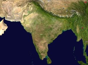
Size and Extension India extends from 8′ 4′ north to 37′ 6′ north latitude and 68′ 7′ east to 97′ 25′ east longitude. us, its latitudinal and longitudinal extent is about thirty degrees. Away from the mainland of India, the southernmost point of the country in the Andaman and Nicobar Islands, the Indira Point is located at 6′ 45′ north latitude. Its north-south extent from Kashmir to Kanniyakumari is 3,214 km while its east-west width from the Rann of Kachh to Arunachal Pradesh in 2,933 km. India’s territorial limit further extends towards the sea upto 12 nautical miles (about 21.9 km) from the coast. (One nautical mile = 72,960 inches). The longitudinal difference between Saurashtra in the west and Arunachal Pradesh in the east is about 30′. Since Arunachal Pradesh is towards the east, it will have sunrise about two hours before the sunrise at Saurashtra. The meridian of 82’30’ east has been selected as the Central Meridian or Standard Meridian which gives us the Indian Standard Time (IST). Indian Standard Time (IST) is ahead of Greenwich Mean Time (GMT) by 5 hours and 30 minutes. The total area of the country is 3.28 million sq. k m which is about 2.4 per cent of the total geographical area of the world. This makes India the seventh largest country of the world. Six countries larger than India are Russia (17.07 million sq. km), Canada (9.98 million sq. km), U.S.A. (9.63 million sq.km), China (9.59 million sq. km). Brazil (8.51 million sq. km) and Australia (7.69 million sq. km). The Tropic of Cancer passes through the middle of the country. India shares its 15,200 km long land border with Bangladesh and Myanmar in the east; China, Nepal and Bhutan in the north and Pakistan and Afghanistan in the north-west. Length of India’s border with neighbouring countries in kms
| Country Length of | Border | |
| 1. | Bangladesh | 4,096 kms |
| 2. | China | 3,917 kms |
| 3. | Pakistan | 3,310 kms |
| 4. | Nepal* | 1,752 kms |
| 5. | Myanmar | 1,458 kms |
| 6. | Bhutan | 587 kms |
| 7. | Afghanistan | 80 kms |
| Total | 15,200 km |
Survey conducted by using Global Positioning system in 2013 has revealed that Indo-Nepal border is 1868 km. However, also have been told to use 1752 km length for the time being. The mainland of India has 6,100 km coastline which is its sea frontier. If the coast-lines of Andaman and Nicobar Islands as well as those of the Lakshadweep Islands are added, the sea frontier of India stretches to 7,517 km. Obviously, India is a vast country. With a total population of over 121 crore according to Census of India 2011, India is the second largest country in the world with respect to population, next only to China (134 crore), South of the 22′ north latitude, the Indian Peninsula tapers towards the Indian Ocean and divides it into two parts. The western and the eastern parts are known as the Arabian Sea and Bay of Bengal respectively. These seas have played a significant role in strengthening the trade and cultural contacts of India with Africa, South-west Asia and South-east Asia. However, at other times, these seas have acted as barriers to human interaction. The present day India comprises 29 States and 7 Union Territories. Rajasthan is the largest and Goa is the smallest State with respect to area. Further, it is worth noting that Uttar Pradesh has the largest population while Sikkim has the smallest population.
Last Modified: April 15, 2026