
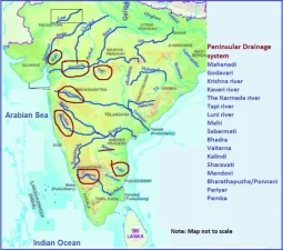
The main rivers of the Peninsular Plateau originate from the Western Ghats and in a west-east direction to join the Bay of Bengal. The important rivers are the Mahanadi, the Godavari, the Krishna and the Cauveri. The Narmada and the Tap i are two exceptions which w in river valleys in east-west direction to join the Gulf of Khambhat. Rivers flowing in the Bay of Bengal
The Mahanadi
The Mahanadi has its source in the northern foothills of Dandakaranya near Sihawa in Raipur district of Chhattisgarh and flows through Odisha to the Bay of Bengal. The drainage basin, extending over 1,41,600 sq. km is shared by Chhattisgarh Madhya Pradesh, Odisha, Bihar and Maharashtra. The total length of the river is 857 kilometres. The Seonath, Hasdo, Mand and the Ib join the Mahanadi on the lebank and the Jonk, Ong and Tel join it on the right bank.
The Godavari
The Godavari is the largest of the peninsular rivers. It rises in the Nashik district of Maharashtra and joins the Bay of Bengal in Andhra Pradesh. Its total length is 1,465 kilometres. The drainage basin extends over 3,12,812 sq. km. About 50% of its drainage basin lies in Maharashtra. The remaining basin of this river is shared by Madhya Pradesh, Karnataka, Odisha, Telangana and Andhra Pradesh. The Godavari is often referred to as Vridha Ganga or Dakshina Ganga because of its large size and extent. Its principal tributaries includes the Pravara, Purna, Manjra, Penganga, Wainaganga, Wardha, Pranhita, Indravati, Maner and the Sabari. Among them, the Manjra, Penganga and the Wainganga are the largest and together account for 1,15,832 sq kms of the drainage basin.
The Krishna
The Krishna rises from a spring near Mahabaleshwar. Its total length is 1,400 kilometres. This is shared by Maharashtra, Karnataka and Andhra Pradesh. Along with its main tributaries, such as Telangana Koyana, Ghataprabha, Malapratha, Bhima, Tungabhadra, Musi and the Muneru, the Krishna drains an area of 2,58,948 sq km.
The Cauveri
Rising in the Brahmagir range of the western Ghats, the Cauveri ws for 800 kilometres to join the Bay of Bengal near Kaveripatnam. Its drainage area of 87,900 sq. km is shared by Kerala, Karnataka and Tamil Nadu. The Cauvery river is distinctly different from other peninsular rivers in the sense that it receives water throughout the year. In summer, it receives water from the south-west monsoons from the Arabian sea and in winter, it receives water from the retreating north-east monsoon. Thus it is a perennial river. This river is joined by the Lakshmanatirtha, Kabini, Survarnavati, Bhawani and the Amravati on the right bank, and Herangi, Hemavati, Shimsha and the Arkavati on the leank.
Subarnarekha and the Brahmani
The Subarnarekha and the Brahmani, interposed between the Ganga and the Mahanadi deltas, drain an area of 19,300 sq. km and 39,033 sq. km respectively. The drainage basins of these streams are shared by Jharkhand, Odisha, West Bengal and Chhattisgarh. The Brahmani is known as south Koel in its upper reaches in Jharkhand.
Rivers owing in the Arabian Sea
The Narmada
It rises near Amarkantak in Madhya Pradesh, flows westwards for a distance of 1,300 kilometres to empty itself in the Arabian Sea below Broach. The drainage basin extends over 98,796 sq. km and is coned mostly to Madhya Pradesh. Only one-tenth of the basin area lies in Gujarat. The picturesque gorge of the Narmada in the marble rocks near Jabalpur in Madhya Pradesh in quite well-known. Another feature of the Narmada Basin is the lack of development of the tributary streams.
The Tapi
The Tapi, rising in the Betul district of Madhya Pradesh, flows westwards for 724 kilometres in a trough basin more or less parallel to the Narmada. It is, however, much smaller both in terms of channel length and the catchment area. The basin area of the Tapi extends over 65,145 sq. km. in Madhya Pradesh, Maharastra and Gujarat. The Tapi is joined by the Purna, Veghar, Girna, Bori and the Panjhra on the left bank and by Aner on the right bank.
The Sabarmati and the Mahi
The north-western bank of the plateau is drained by the Sabarmati and the Mahi. The Sabarmati rises in the Aravali hills and flows south-south-westwards for a distance of 300 kilometres to the Arabian Sea. The Sabarmati basin extends over an area of 21,674 sq. km in Rajasthan and Gujarat. The Mahi rises in the east of Udaipur and drains an area of 34,842 sq. km lying in Madhya Pradesh, Rajasthan and Gujarat. It flows south-westwards for a distance of 533 km before it falls into the Gulf of Khambhat.
The Chambal, the Sind, the Betwa, the Ken and the Son
These rivers originate from the northern bank of the Peninsular Plateau and join the Ganga river system to the northern plain. The Chambal rises near Mhow in the Vindhya Range and flows towards the north generally in a gorge upto Kota. Below Kota, it turns to the east and runs nearly parallel to the Yamuna, before joining it in the southern part of the Etawah district in Uttar Pradesh. The river flows much below its banks due to severe erosion because of poor rainfall and numerous deep ravines have been formed in the Chambal valley giving rise to badlands or badland topography. The term badland is applied to any such erosion landscape, where a maze of ravines and valleys dissect plateau surfaces. It is 1,050 km long. Sind, the Betwa and the Ken, wing towards the north, have also cut deep gorges at some places and like the Chambal have carved out numerous ravines in the alluvial plain of the Ganga. The Son originates from the Amarkantak Plateau. After flowing for some distance to the north, it meets the Kaimur Range which turns its course towards the north-east. Almost all of its tributaries join on its right bank. It merges into the Ganga near Ramnagar. It is 780 km long.
Last Modified: April 16, 2026