
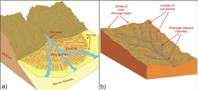
Alluvial cones and alluvial fans are formed by the river at the foothills. The velocity of river water is suddenly reduced due to reduction in slope when it enters the plains after leaving the mountains. Hence, the rock material brought down by the river from highlands is deposited at the foothills. This is generally coarser material composed of sand, gravel and boulders. In due course of time, the deposited material projects like a cone from the foothill and is known as alluvial cone. Such alluvial cones are found in Death Valley and San Juan Mountains.
The river crosses alluvial cones by dividing itself in many channels and forms alluvial fans. Alluvial fan is semi-circular in form and points upstream. It is broader than alluvial cone but its height is less than the alluvial cone. Almost all the rivers coming out of the Himalayas, Rockies and Andes mountains form alluvial fans.
A river normally follows curved path rather than going straight. To and fro movement of the river channel across its plain results in developing S-shaped meanders, common to all rivers of large size. ‘Meander’ is derived from the name of a small winding river ‘Meanders’ in Turkey. The speed of the river water slows down and the river does both the works of erosion as well as deposition. The river becomes so weak that even a small obstruction will force it to bend its path. Once the process of curve formation starts it goes on increasing with the passage of time. When the river begins to swing in large curves, it does the erosional work on its concave bank and depositional work on its convex bank. This is because the speed of river water is more on the concave bank and less on the convex bank.
In the lower course of the river the slightest slackening of speed at once results in deposition so that silt accumulates at the bottom and the sides of the river. After a long time, the bed of the river is raised and it was between raised banks along a bed which is at a higher level than the plains on either side.
Such raised banks or embankments are known as natural levees. Natural levees often save the surrounding areas from the fury of floods. But when these levees yield to the excessive pressure of the river water, it folds the entire area surrounding it. Most of the sediment of the river is deposited there after the flood is over. In this way, a vast plain is formed which is known as flood plain. The flood plains receive fresh soil every year and are very fertile. Rivers Huang He, Mississippi, Ganga, Indus, Nile, etc. have formed extensive flood plains.
When the river enters the sea or a lake, it deposits all the load at its mouth giving rise to the formation of a delta. It is a triangular feature with its apex pointing upstream and is marked as a fan-shaped area of the alluvium. The Greek letter ‘D’ (delta) closely resembles the triangular delta of river Nile. The mud deposited along the banks becomes an obstacle and divides the river into numerous branches called distributaries. The Ganga-Brahmaputra Delta, 1,25,000 sq. km. in area, is the biggest delta of the world. Other well-known deltas are those of rivers Nile, Mississippi, Po, Volga and the Yangtze.
Landforms Made By Groundwater
Part of the surface water percolates in the ground and is termed as groundwater. Underground water flows slowly and its physical erosional power is negligibly small. However, underground water is an important agent of erosion. Erosion by underground water includes four different activities : corrosion, attrition, solution and hydraulic action. Of all these activities, solution is the most important process. Rain water containing certain dioxide goes underground and acts as a good solvent in a limestone area. A limestone area where underground water is more effective is known as ‘Karst’ topography. It is so named after a province of Yugoslavia on the Adriatic sea coast where such formations are most noticeable. Underground water produces a large variety of features through its erosional and depositional works.
Sink Hole
A sink hole is a funnel-shaped depression which has an average depth of three to nine metres. The area of a sink hole may be one square metre or more. Sink holes are developed by enlargement of the cracks found in rocks containing limestone, as a result of continuous solvent action of the rainwater. Sometimes, streams disappear into them leaving their beds dry, and sometimes springs fed by the lost stream may w out from the sink. The beds of the dry streams appearing in this way are known as blind valleys. The best example is that of the limestone plateau of Kentucky in the United States of America, where over 60,000 sink holes are found. In India, these are observed along the southern edge of Meghalaya’s limestone strata.
Swallow Holes
Swallow holes are cylindrical in shape lying underneath the sink hole at some depth. e surface streams that often sink suddenly disappear underground through them. They justify their names by virtually swallowing the sub-surface streams which may reappear from rock opening further down the slopes. When a sink hole is enlarged due to solution of the rocks by underground water, it becomes a doline. This name has been taken from the dolines of Karst region of Yugoslavia. Dolines are funnel-shaped at the surface and cylindrical below it. They are 8-12 metres wide and 4-20 metres deep. The walls of adjacent dolines collapse due to solution by underground water and they coalesce into a bigger hole known as Uvala. Sometimes uvalas are filled with water obtained from heavy rainfall. They suffer large scale erosion and many uvalas combine to form a sort of cave which is known as ponor. Sometimes a river falls into it and form bigger ponor.
Cavern
In certain areas, there are hard insoluble rocks at the surface and soluble limestone below it. The underground water dissolves the limestone from below while the upper rock remains intact like a roof. Thus, a cave is formed. A large limestone cave formed by solution due to underground water is known as Cavern. A part of the roof of a cavern collapses, but part of it remains intact and looks like a bridge. Since this bridge is made by nature, it is called natural bridge. The depositional work of underground water leads to the formation of stalactites, stalagmites and cave pillars. The water, containing limestone in solution, seeps through the roof of the caverns in the form of a continuous chain of drops. A portion of the drops hangs on the roof and on the evaporation of water, a small deposit of limestone is left behind contributing to the formation of a stalactite. A stalactite grows downwards from the roof. Its thickness is maximum near the roof and it thins out downwards. The remaining portion of the drop falls to the floor of the cavern. This also evaporates, leaving behind a small deposit of limestone aiding the formation of stalagmite, thicker and flatter, rising upwards from the floor. Its thickness is maximum at the floor of the cavern and it thins out upwards. Sometimes a stalactite from above and stalagmite from below develop towards each other and combine together to form a pillar. This is known as cavern pillar or column.
Last Modified: February 18, 2024