
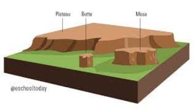
Plateaus, majestic elevated landforms characterized by their vast flat or gently rolling terrain, have intrigued geologists and fascinated travelers for centuries. These extensive, high-elevation regions cover substantial areas of the Earth’s surface and hold valuable insights into the planet’s geological history.
Tectonic Uplift: The Backbone of Plateau Formation
Plateaus owe their genesis to tectonic uplift—a fundamental geological process driven by the movement of Earth’s lithospheric plates. This process is typically initiated by the collision of tectonic plates or the convergence of continental or oceanic plates, leading to immense forces that elevate extensive land masses over millions of years.
- Example: The Tibetan Plateau The Tibetan Plateau, often referred to as the “Roof of the World,” is a prime example of a tectonically uplifted plateau. It resulted from the ongoing collision between the Indian and Eurasian plates, which began around 50 million years ago and continues to this day. The gradual convergence of these plates has led to the substantial uplift of the Tibetan Plateau, making it one of the highest and most extensive plateaus on Earth.
Volcanic Activity: Building Plateaus from the Depths
Another significant mechanism for plateau formation is volcanic activity. Large-scale volcanic eruptions can release massive amounts of lava, ash, and volcanic debris onto the Earth’s surface, gradually building up extensive highland regions.
- Example: The Deccan Plateau The Deccan Plateau in India serves as a remarkable example of a plateau formed due to volcanic activity. Approximately 66 million years ago, a series of colossal volcanic eruptions, known as the Deccan Traps, released vast amounts of lava across the region. The accumulation of these lava flows over millions of years eventually gave rise to the Deccan Plateau, covering an area of over 500,000 square kilometers.
Erosion and Uplift: The Sculpting of Plateaus
Erosion and uplift are two interconnected processes that play a crucial role in shaping plateaus. While uplift elevates the land, erosion works tirelessly to wear it down, resulting in the creation of vast, flat expanses with distinct geological features.
- Example: The Colorado Plateau The Colorado Plateau in the United States is a captivating illustration of a plateau formed through the interplay of erosion and uplift. Around 70 million years ago, tectonic forces uplifted this region, and over time, the Colorado River and its tributaries carved out the iconic canyons and mesas, exposing a breathtaking landscape of sedimentary rock layers.
Key Data Table: Prominent Plateaus Worldwide
| Plateau | Location | Area (sq. km) | Average Elevation (meters) |
| Tibetan Plateau | Asia | 2,500,000 | 4,500 |
| Deccan Plateau | India | 500,000 | 600 |
| Colorado Plateau | USA | 337,000 | 2,440 |
| Altiplano | South America | 200,000 | 3,750 |
| Ethiopian Plateau | Africa | 200,000 | 2,500 |
The formation of plateaus is an intricate and dynamic process shaped by various geological forces. Whether arising from tectonic uplift, volcanic activity, or erosion and uplift, these elevated landforms provide invaluable insights into the Earth’s geological history and continue to be essential components of our planet’s diverse landscapes.
Last Modified: February 22, 2024