
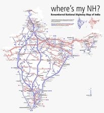
The main roads which are constructed and maintained by the Central Public Works Department (CPWD) are known as the National Highways. These roads connect the state capitals, big cities and important ports. ere was a road length of 19,700 km designated as National Highways in 1950-51 which increased to 70,934 km in 2013. The national highways constitute only 2 per cent of the total road length but carry about 40 per cent of the trac. National Highways link extreme parts of the country. A number of major National Highways run in north-south and east-west directions. The historical Sher Shah Suri Marg is called National Highway-1, between Delhi and Amritsar and National Highway-2 between Delhi and Kolkata. National Highway-3 links Agra to Mumbai viza. Gwalior.
National Highway-6 is the second longest trunk route (1949 km) and runs between Kolkata and Dhule via Sambalpur, Raipur and Nagpur. National Highway-7 is the longest one and traverses 2,369 km between Varanasi and Kanniyakumari via Jabalpur, Nagpur, Hyderabad, Bangalore and Madurai. Delhi and Mumbai are connected by National Highway-8. National Highway-15 covers most of the Rajasthan desert. National Highways Development Project (NHDP) is a massive programme for developing the National Highways. It is being implemented by the National Highways Authority of India (NHAI) in the following phases:
NHDL Phase I & II: Envisage 4 ‘ 6 laning of about 14,000 km of National Highways, at an estimated cost of about Rs 65,000 crore at 2004 prices. These two phases comprise Golden Quadrilateral (GQ), North-South and East-West corridor (NSEW), Port Connectivity and Other Projects. The GQ consists of 5846 km and connects four major cities, viz., Delhi, Mumbai, Chennai and Kolkata. The NSEW corridor comprising a length of 7142 km connects Srinagar in the North to Kanyakumari in the South including a spur from Salem to Kochi and Silchar in the East to Porbandar in the West, respectively. The NHDP also includes Port Connectivity Project comprising a length of 380 km for improvement of roads connecting 12 major ports in the country and other projects involving a length of 965 km are also included.
NHDP Phase III: NHDP Phase-III involves 4-laning of 12,109 km of NHS having high density corridor connecting State capitals, important tourist places, economically important areas, etc. on PPP basis at an estimated cost of Rs 80,628 crore.
NHDP Phase IV: It involves upgration / strengthening of 20,000 km of single / intermediate / two lane National Highways to two lanes with paved shoulders on BOT (Toll) and BOT (Annuity) basis.
NHDP Phase V: It involves six laning of 6,500 km of NHs comprising 5,700 km of GQ and balance 800 km of other sections of NHs at a cost of Rs 41,210 crore.
NHDP Phase VI: It involves construction of 1,000 km of expressways with full access control on new alignments at a cost of Rs 16,680.
NHDP Phase VII: It involves construction of 700 km of ring roads of major towns and bypasses and construction of other stand-alone structures such as yovers, elevated roads, tunnels, underpasses, grade separated interchanges etc. on National Highways at a cost of Rs 16,680 crore.
The overall progress of NHDP as on December, 2012 is as under:
| Phases | Total | 4/6 laned | Under implementation | Balance | |
| (km) | (km) | km | contracts | forward | |
| (No) | |||||
| GQ | 5,846 | 5,846 | 0 | 8 | – |
| NS & EW Corridors | 7,142 | 6,053 | 722 | 59 | 367 |
| Port connectivity | 380 | 318 | 62 | 4 | 0 |
| Other NHs | 1,390 | 964 | 406 | 4 | 20 |
| SARDP-NE | 388 | 49 | 63 | 2 | 276 |
| NHDP Phase | |||||
| III | 12,109 | 4,602 | 5,734 | 90 | 1,773 |
| IV | 20,000 | 62 | 4,300 | 31 | 15,638 |
| V | 6,500 | 1,276 | 2,804 | 28 | 2,420 |
| VII | 700 | 19 | 22 | 2 | 659 |
India: Some Important National Highways
| No | Route | Length (km) |
| 1. | Delhi-Ambala-Jalandhar-Amritsar | 456 |
| 1A | Jalandhar-Madhopur-Jammu-Srinagar-Baramula-Uri | 663 |
| 1B. | Batot-Doda-Kishtwar | 107 |
| 2. | Delhi-Mathura-Agra-Kanpur-Allahabad-Varanasi-Mohania-Barthi-Kolkata | 1490 |
| 3. | Agra-Gwalior-Shivpuri-Indore-Dhulia-Nashik-ane-Mumbai | 1161 |
| 4. | ane-Pune-Belgaum-Hubli-Bengaluru-Ranipet-Chennai | 1235 |
| 4A. | Belgaum-Anmode-Ponda-Panaji | 153 |
| 5. | Bahargagora-Cuttack-Bhubaneshwar-Vishakhapatanam-Vijyawada-Chennai | 1533 |
| 6. | Dhule-Nagpur-Raipur-Sambalpur-Baharagora-Kolkata | 1645 |
| 7. | Varanasi-Rewa-Jabalpur-Nagpur-Hyderabad-Bangalore-Madurai-Kanniyakumari | 2369 |
| 8. | Delhi-Jaipur-Ajmer-Udaipur-Ahmadabad-Vadodara-Mumbai | 1428 |
| 9. | Pune-Solapur-Hyderabad-Vijayawada | 791 |
| 10. | Delhi-Fazilka | 403 |
| 11. | Agra-Bharatpur-Jaipur-Bikaner | 582 |
| 12. | Jabalpur-Bhopal-Kota-Bundi-Jaipur | 890 |
| 13. | Solapur-Chitradurga | 491 |
| 14. | Beawar-Sirohi-Radhanpur | 450 |
| 15. | Pathankot-Bathinda-Bikaner-Jaisalmer | 1526 |
| 16. | Barmer-Samkhiyali-Jagdalpur | 460 |
| 17. | Panvel-Mangalore-Edapalli | 1269 |
| 18. | Kurnool-Nandyal-Cuddapah-Chittoor | 369 |
| 19. | Pathankot-Mandi | 220 |
| 20. | Chandigarh-Ropar-Mandi-Kulu-Manali | 323 |
| 21. | Ambala-Kalka-Shimla-Narkanda-Rampur-Chini | 462 |
| 22. | Chas-Ranchi-Rourkela-Talwar | 459 |
| 23. | Delhi-Bareilly-Lucknow | 438 |
| 24. | Lucknow-Kanpur-Jhansi-Shivpuri | 319 |
| 25. | Jhansi-Lakhnaden | 396 |
| 26. | Allahabad-Mangawan | 93 |
| 27. | Baauni-Muzarpur-Gorakhpur-Lucknow | 570 |
| 27A. | Pipra-Sagauli-Razaul | 68 |
| 28. | Gorakhpur-Ghazipur-Varanasi | 198 |
| 29. | Mohania-Patna-Bakhtiyarpur | 230 |
| 30. | Bakhtiyarpur-Siliguri-Nalbari-Aminagaon | 1125 |
| 30A. | Sivok-Gangtok | 92 |
| 31. | Govindpur-Dhanbad-Jamshedpur | 179 |
| 32. | Barthi-Ranchi | 352 |
| 33. | Dalkhola-Barasat-Kolkata | 443 |
| 34. | Barasat-Bangaon | 61 |
| 35. | Nagaon-Dabaka-Dimapur | 170 |
| 36. | Goalpara-Guwahati-Kamargaon-Saikhoa Ghat | 680 |
| Indian and World Geography 157 | ||
| 37. | Makum-Ledo-Lekhapani | 54 |
| 38. | Numiligarh-Imphal-Palel | 436 |
| 39. | Jorhat-Shillong-Dawki | 161 |
| 40. | Kolaghat-Haldia | 51 |
| 41. | Sambalpur-Angul-Cuttak | 261 |
| 42. | Raipur-Vizianagaram | 560 |
| 43. | Shillong-Passi-Badarpur-Agartala | 495 |
| 44. | Chennai-Tiruchchirappalli-Dindigul | 387 |
| 45. | Krishnagiri-Ranipet | 132 |
| 46. | Salem-Coimbatore-uvananthapuram-Kanniyakumari | 640 |
| 47. | Bangalore-Hassan-Mangalore | 328 |
| 48. | Kochi-Madurai-Dhanushknodi | 440 |
| 49. | Nashik-Pune | 192 |
| 50. | Pekana-Tura-Dalu | 149 |
| 51. | Baihata-Charali-Tezpur-Lakhimpur-Sekhoghat | 850 |
| 52. | Badarpur-Zirighat-Imphal-Silchar | 320 |
| 53. | Silchar-Aizawl | 560 |
| 54. | Siliguri-Darjeeling | 77 |
| 55. | Lucknow-Varanasi | 285 |