Champaner, situated at the base of the Pavagadh hill in the Panchmahal district of Gujarat, emerged as a critical political and strategic node during the medieval period. Its unique topography allowed successive regional rulers to control the trade corridors connecting the fertile plains of Gujarat with Malwa and Northern India.
Pre-Sultanate Foundation and Chauhans
- Rajput Origins: The city was originally founded in the 8th century CE by Champa, a minister of King Vanraj Chavda of the Anhilwada kingdom.
- Khichi Chauhan Stronghold: By the 13th century, Khichi Chauhan Rajputs seized control of the region, establishing an independent principality. They fortified the upper ridges of the Pavagadh hill, constructing a multi-tiered fortress network that successfully repulsed early military incursions by the Delhi Sultanate.
The Siege and Muzaffarid Conquest (1482–1484 CE)
- The Strategic Trigger: In 1482 CE, the Chauhan ruler Jayasimha Raval launched a raid into the territories of the Gujarat Sultanate. This provoked a massive punitive expedition by Sultan Mahmud I, popularly known as Mahmud Begarha.
- The Twenty-Month Siege: The Sultanate forces surrounded both the base town of Champaner and the upper Pavagadh citadel. Following a brutal twenty-month siege, the Rajput defenses were breached, forcing the royal women to commit Jauhar while Jayasimha Raval was captured and executed.
- Proclamation as Imperial Capital: Upon capturing the stronghold, Mahmud Begarha earned the title Begarha (Conqueror of Two Forts—Junagadh and Champaner). He permanently shifted the imperial capital of the Gujarat Sultanate from Ahmedabad to Champaner, renaming the urban center Muhammadabad-Champaner.
Urban Planning, Zoned Layout, and Hydro-Engineering
Under the direct supervision of Mahmud Begarha, Champaner was completely rebuilt from a medieval Rajput hill-town into a meticulously planned Islamic metropolis. The city showcases advanced engineering, defense mechanisms, and water-harvesting systems.
Defensive Grid and Zoned Layout
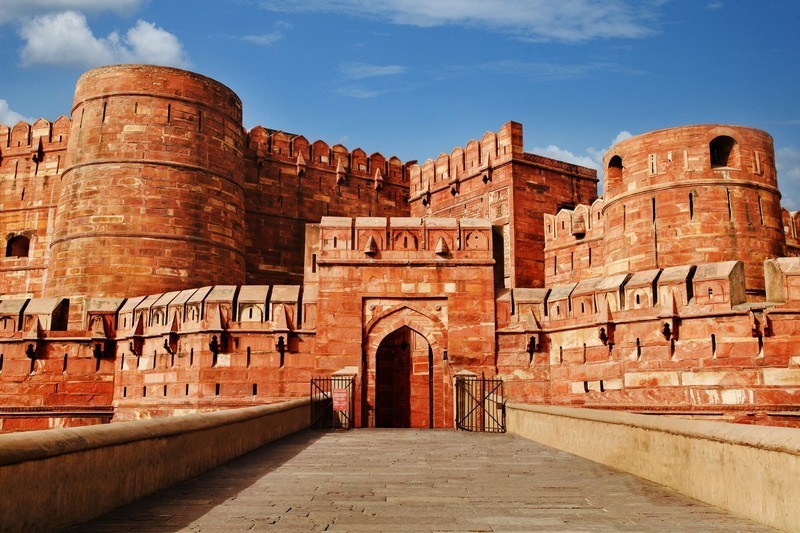
- Jahanpanah (The Inner Citadel): The urban core was anchored on a rectangular royal enclosure fortified by massive sandstone walls, square bastions, and ornate gateways. This inner core housed the Sultan’s palaces, central administrative offices, the state treasury, and high-status residential quarters.
- The Outer Suburbs (Puras): The civilian population, merchant guilds, and specialized craft communities were settled outside the citadel wall in planned suburbs (Puras). Each Pura was designed around a central marketplace and neighborhood mosque to optimize economic activity and municipal management.
- Military Defenses: The upper Pavagadh hill was kept as a highly fortified military reserve. It featured multiple defensive checkpoints, rock-cut ditches, and narrow stone staircases that could be easily blocked during an invasion.
Subterranean Hydro-Engineering and Water Governance
- Rainwater Harvesting Networks: Because the region lacks natural perennial river networks, Champaner’s builders engineered a comprehensive water-harvesting system. Rainwater from the Pavagadh hills was captured and channeled through stone conduits into a series of interconnected storage tanks and stepwells.
- The Hauz-i-Vazu System: Large artificial reservoirs, such as the Bada Talao, regulated the urban water supply and fed the internal cooling systems of royal palaces, gardens, and mosque complexes.
- Architectural Stepwells: Subterranean stone stepwells (Vavs) were built to ensure a regular water supply during drought cycles. Notable structures, like the Helical Stepwell, combined deep well-shafts with winding staircases and open-air platforms, doubling as civic gathering spaces.
The Champaner Style: Architectural Synthesis
The monuments of Champaner represent the highest development of the Gujarat Provincial Style of architecture. Local Hindu and Jain artisans combined their native stone-carving traditions (Maru-Gurjara idiom) with Islamic structural systems, creating a distinct architectural style.
Distinctive Architectural Elements
- The Hybrid Structural Template: Builders used the beam-and-bracket (trabeate) system to support interior flat ceilings, while employing arches and domes (arcuate) for exterior profiles and grand entrances.
- The Symmetrical Minaret Facade: Unlike earlier mosques where minarets were freestanding or attached to corner walls, the Champaner style positioned two decorative minarets symmetrically on either side of the main entrance portal.
- Perforated Sandstone Jalis: High-fired yellow sandstone panels were intricately carved into openwork screens (jalis), filtering direct sunlight and enabling continuous airflow inside the structures.
Key Structural Masterpieces of the Capital
Jami Masjid of Champaner
- Construction Timeline: Completed in 1508 CE during the peak of Mahmud Begarha’s reign.
- Key Design Features: It features a massive central dome that rises three stories high, supported by an internal grid of columns. The eastern facade contains two highly detailed 30-meter minarets, a triple-arched entrance, and a raised screen wall decorated with geometric and floral patterns. The interior includes a separate, elevated gallery for the royal family (Badshah-ka-Takht).
Kevda Masjid and Cenotaph
- Key Design Features: This mosque is known for its rectangular layout, multi-domed roof, and an open central nave. The accompanying freestanding tomb (cenotaph) features a fluted dome and columns with intricate carvings influenced by Jain temple traditions.
Nagina Masjid
- Key Design Features: Built entirely of pure white sandstone, this monument features a highly decorative main porch, geometric stone lattices, and corner minarets covered in deep-relief carvings.
Lila Gumbaj Ki Masjid
- Key Design Features: Named after the vibrant turquoise and blue glazed tiles that originally covered its central dome. The structure features high-sprung central arches and fluted minarets that showcase architectural links with Central Asian designs.
Socio-Economic Core and Maritime Trade Linkages
The Monetary Matrix
- The Central Mint: Champaner was designated as a primary imperial mint town (Dar-ul-Zarb), issuing high-purity silver Taka and copper coins under the mint-mark “Muhammadabad.” These coins standardized financial transactions and trade agreements across western India.
- The Cowrie Currency Exchange: For everyday local trade, the city’s markets used imported Maldivian cowrie shells as fractional currency. This allowed agrarian laborers to easily exchange goods within the urban economy.
Industrial Production and Global Commercial Networks
- Textile Manufacturing Hub: The state established royal workshops (Karkhanas) within the city, attracting skilled weavers and block-printers. Champaner specialized in manufacturing luxury silk embroideries, colored cotton textiles, and gold-brocade velvets.
- The Indigo and Agate Pipelines: The city functioned as the central collection point for high-grade indigo cultivated in central Gujarat, as well as semi-precious stones (agate and carnelian) mined in Cambay. These raw materials were processed in Champaner before being exported worldwide via the deep-water ports of Surat, Diu, and Cambay.
Decline, Fall, and Abandonment
The Mughal Incursion (1535 CE)
- The Humayun Siege: Following the death of Bahadur Shah, the Mughal Emperor Humayun launched an invasion of Gujarat. He targeted Champaner due to its status as the imperial treasury.
- The Fortress Breach: Humayun personally led an assault party up the steep cliffs of Pavagadh, using iron spikes driven into the rock face to scale the walls and capture the upper citadel, plundering the Sultanate’s treasures.
Shift of Capital and Environmental Invasions
- Return to Ahmedabad: Following the Mughal withdrawal, successive puppet Sultans struggled to maintain the city, eventually shifting the permanent administrative headquarters back to Ahmedabad due to its superior river networks.
- The Permanent Abandonment: Deprived of royal patronage and state funds, Champaner’s complex water-harvesting systems collapsed. A series of malaria outbreaks and a lack of fresh water caused residents to flee the city. The jungle reclaimed the brick palaces and sandstone mosques, preserving them as an intact, unaltered archaeological footprint of a pre-Mughal Islamic capital.
Historical Matrix of Champaner Monuments
| Monument Name | Structural Medium | Core Architectural Attribute | Historical Significance |
| Jami Masjid | Yellow Sandstone | Three-storied central nave; symmetrical minarets; royal gallery. | The architectural masterpiece of the Muzaffarid era. |
| Nagina Masjid | White Sandstone | Ornate entrance porch; detailed relief carvings on minarets. | Represents the mature phase of stone craftsmanship. |
| Kevda Masjid | Sandstone & Brick | Open central nave; detached multi-tiered cenotaph chamber. | Demonstrates a clear blend of Hindu-Jain and Islamic patterns. |
| Lila Gumbaj | Sandstone & Glazed Tiles | Fluted central dome; high-sprung arches; fluted towers. | Showcases Central Asian tilework techniques. |
| Helical Stepwell | Sandstone | Coiled stone staircase descending into an octagonal well-shaft. | Important example of medieval water engineering. |
UPSC Prelims Historical Trivia
The Global UNESCO Recognition
The Champaner-Pavagadh Archaeological Park stands as the only complete, unaltered pre-Mughal Islamic city remaining in India. Because it was abandoned shortly after its peak without subsequent Mughal or British rebuilding, its layout provides historians with a clear, intact record of 15th-century Indo-Islamic urban planning and civic engineering.
Humayun’s Scaling Strategy
Contemporary Mughal chronicles record that during the siege of 1535 CE, the Mughal Emperor Humayun observed local wood-cutters using narrow footholds to navigate the sheer cliffs of Pavagadh. He used this observation to design iron spikes that his elite guard hammered into the rock face during a night assault, allowing them to bypass the heavily fortified main gateways.
The Silk Weavers’ Migration
When Mahmud Begarha established Champaner as his capital, he ordered the forced migration of entire communities of silk weavers from Patan to the new city. These weavers developed a specialized silk-weaving industry that produced multi-colored brocades, laying the foundation for the regional textile trade that European merchants later documented in the 16th century.
Last Modified: June 22, 2026