Kumbhalgarh Fort occupies a highly strategic position in the Rajsamand district of Rajasthan, situated on the westerly range of the Aravalli hills. Built by Maharana Kumbha between 1443 and 1458 CE on the site of an ancient 2nd-century BCE Jain structure attributed to King Samprati, the fort was engineered to secure medieval Mewar across three key regional fronts:
- The Eastern Region Core Guard: It functioned as an impregnable rear defense stronghold for Mewar’s eastern riverine core plains (Chittorgarh and Udaipur), serving as a secure refuge when the open eastern frontiers faced heavy siege.
- The Western Desert Interface: Situated on the high ridges bordering the historic Godwar tract, the fort acted as a volatile border outpost monitoring Marwar (Jodhpur). It controlled the crucial military and commercial trade routes moving from the northern plains of Delhi and Agra toward the maritime trade ports of Gujarat.
- The Frontier Highlands Rim: Located on an alpine peak approximately 1,100 meters above sea level, the fort dominated the rugged tribal zones populated by the Bhils and Meenas. This high-altitude positioning acted as an insulation barrier against multi-front incursions from the neighboring Sultanates of Malwa and Gujarat.
Topographical Exploitation and Defensive Engineering
The architecture of Kumbhalgarh is heavily integrated into its natural topography. The fortress is built across thirteen distinct mountain peaks (such as Nilkanth, Jarga, and Kamalanath) and overlooks narrow mountain passes (Naals). This geographic layout allowed the rulers of Mewar to neutralize numerically superior cavalry and heavy artillery forces by drawing them into high-altitude, closed-terrain defensive traps.
Architectural Layout and Military Infrastructure
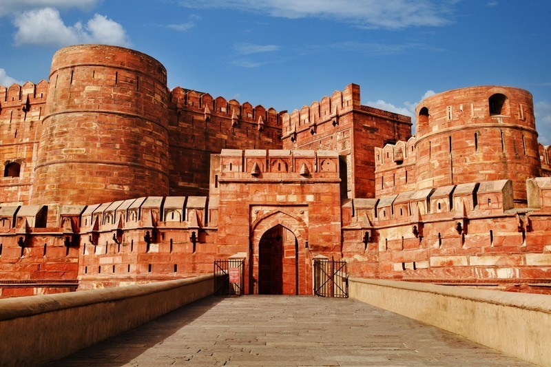
The Great Wall of Kumbhalgarh
The primary defensive feature of the fort is its monumental outer perimeter wall, which stands as a masterpiece of medieval military engineering:
- Dimensions and Scale: The wall extends continuously for over 36 kilometers, making it one of the longest continuous fortification walls in the world.
- Structural Prowess: Constructed from massive dressed stone blocks, the wall varies in width from 15 to over 21 feet, intentionally engineered to allow eight cavalry horses to march abreast along its battlements.
- Tapering and Merlons: The wall features crenellated battlements, loop-holed merlons for archers and musketeers, and a tapering profile that absorbs shock from medieval battering rams and primitive siege cannons.
Gateways and Strategic Checkpoints
Access to the inner core of Kumbhalgarh is controlled through a series of seven heavily fortified sequential gateways (Pols) designed to prevent direct cavalry charges and break the momentum of invading forces:
| Gateway Name | Strategic Administrative and Military Function |
| Aret Pol | The outermost defensive barrier, acting as a high-altitude watchtower over the mountain approach road. |
| Halla Pol | Features a sharp, angled turn designed to shatter the forward momentum of war elephants and battering rams. |
| Hanuman Pol | Houses a monumental stone idol of Lord Hanuman brought by Rana Kumbha from his campaigns in Mandore. |
| Ram Pol | The primary entrance gate to the inner town, showcasing classical Kalinga-style architectural carvings. |
| Bhairon Pol & Nimboo Pol | Inner intermediate checkpoints guarding the direct paths to the royal citadel and residential complexes. |
| Pagda Pol | The final interior gateway leading into the high-walled residential quarters of the Maharana. |
The Internal Citadel: Katargarh
At the absolute apex of the fort lies Katargarh, a distinct self-contained inner citadel known as the “Eye of Kumbhalgarh.” Surrounded by its own high fortification walls and accessed via the Pagda Pol, it served as the personal residential palace complex of the Maharana. Its extreme elevation provided panoramic views over the plains of Marwar and the defiles of Mewar, allowing the ruler to directly observe troop movements across both the western desert and eastern highland frontiers.
Administrative Infrastructure and Resource Extraction
Revenue Allocation and Internal Sustainability
Unlike typical medieval military garrisons that relied entirely on vulnerable external supply chains, Kumbhalgarh was engineered as a self-sustaining eco-system capable of surviving multi-year sieges:
- Agricultural Terrains: The vast interior basin of the fort contains fertile agricultural tracts, step-terraces, and valley patches that were systematically cultivated by resident farmers during prolonged blockades.
- Hydraulic Engineering: Rana Kumbha commissioned advanced water harvesting systems within the fort walls. This included large structural tanks, stepped wells (Baoris), and reservoirs like the Lakhola Tank, the Badshahi Tank, and the Mama Dev Kund, ensuring an uninterrupted water supply for thousands of soldiers and horses.
The Feudal Administrative Grid
Administratively, the fort served as the command center for the western districts of Mewar. It was governed by a royal castellan or Quiladar, who was assisted by a civil administrative network:
| Administrative Office | Core Functional Jurisdiction within the Frontier Grid |
| Quiladar | The supreme military governor responsible for garrison readiness, weapons storage, and wall maintenance. |
| Pana-Pradhan | The local revenue director overseeing agricultural yields within the fort basin and taxing frontier trade. |
| Kotwal | The chief of internal security, responsible for civil order, gate operations, and checking incoming caravans. |
| Bhandari | The grain and treasury registrar managing the imperial underground silos to prepare for siege situations. |
Socio-Religious Pluralism and Cultural Landmark
The Synthesis of Hindu and Jain Monuments
Kumbhalgarh functions as an architectural repository of medieval North Indian temple styles, housing over 360 individual temple structures within its walls. Reflecting the socio-political alliances of the Sisodia dynasty with wealthy merchant guilds, approximately 300 of these are ancient Jain temples, while the remainder are dedicated to the Hindu pantheon.
Iconic Religious Structures
- Nilkanth Mahadev Temple: A monumental temple constructed in 1458 CE dedicated to Lord Shiva. It features a massive six-foot-tall monolithic black stone Lingam and a structured central dome supported by 24 fluted pillars.
- Mamadev Temple and Kund: The site where Rana Kumbha placed the detailed Kumbhalgarh Prasasti stone tablets. It stands near the sacrificial altars used during the fort’s consecration rituals.
- Vedi Temple: A unique three-story ritualistic structure built by Rana Kumbha to perform Vedic sacrifices (Yajnas) after completing the fort’s primary walls. It stands as the only surviving example of a sacrificial pavilion of its kind in Rajasthan.
High-Yield Facts and Historical Trivia for UPSC Prelims
The Sacrifice of Mehrat
According to local historiography and architectural legends, the construction of the fort’s massive walls repeatedly collapsed during the initial phases. A mystic advised Rana Kumbha that a voluntary human sacrifice was required to appease the guardian spirits of the hill. A soldier named Mehrat volunteered; the spot where his severed head fell was marked by the construction of the primary gate, the Hanuman Pol, establishing a sacred boundary for the fort.
The Birthplace of Maharana Pratap
Kumbhalgarh holds a central position in the historical consciousness of Rajputana as the birthplace of Maharana Pratap (born May 9, 1540 CE). He was born inside the Badal Mahal (Palace of Clouds) at the peak of the Katargarh citadel during the reign of his father, Maharana Udai Singh II.
The Triple-Alliance Siege of 1578 CE
Kumbhalgarh’s defensive architecture was so formidable that it was successfully breached only once in its active military history. This occurred in 1578 CE when Shahbaz Khan, a premier general of Mughal Emperor Akbar, led a massive coalition army that united the forces of Delhi, the Sultanate of Gujarat, and the Rathores of Marwar. The fort fell briefly after a catastrophic gunpowder magazine explosion contaminated the primary freshwater supply of the Mama Dev Kund.
The Sanctuary of Udai Singh II
When the treacherous noble Banvir usurped the throne of Chittorgarh in 1536 CE after murdering Vikramaditya, the infant prince Udai Singh II (father of Maharana Pratap) was smuggled out of the palace by his nursemaid, Panna Dhai, who sacrificed her own son to save the lineage. Udai Singh was brought to Kumbhalgarh, where the castellan Asha Shah Depura granted him political asylum, allowing the prince to grow up in hiding before launching his campaign to reclaim Mewar.
The Kumbhalgarh Inscription (Prasasti) of 1460 CE
A foundational epigraph written on five black stone slabs was installed by Rana Kumbha at the Mahadeva Temple inside the fort. Composed by the court scholars Atri and his son Mahesh, this detailed Sanskrit text provides an invaluable historical record of the genealogy of the Guhilot and Sisodia houses, the social structure of 15th-century western India, and the specific military victories of Rana Kumbha over the Sultanates of Malwa and Gujarat.
Last Modified: June 22, 2026