The Kingdom of Marwar, dominated by the Rathore dynasty, occupied the arid and semi-arid tracts of western Rajasthan. In the geopolitical landscape of medieval India, its administrative, economic, and military machinery was distributed across three distinct spatial zones:
- The Western Desert Core: Encompassing the core desert districts of Jodhpur, Bikaner, Nagaur, and Barmer. This hyper-arid region formed the traditional stronghold and structural power base of the Rathore clans, relying heavily on pastoral-agrarian networks and oasis settlements.
- The Eastern Plains Interface: Bordering the fertile plains of Mewar (Udaipur), Hadoti, and Dhundhar (Amber/Jaipur) along the western slopes of the Aravalli Range. This frontier functioned as a highly volatile zone of territorial expansion, inter-clan marriages, and direct military friction.
- The Frontier Outposts: Comprising the northern borderlands extending toward Punjab and Multan, and the southern margins bordering Sindh and the Gujarat Sultanate. These regions required highly specialized frontier garrisons to regulate continental trade routes and secure strategic desert passes.
Topographical Factors in Warfare and Statecraft
The geography of Marwar—characterized by the Thar Desert, sand dunes, acute water scarcity, and isolated granite outcrops—dictated its military strategy. Rathore commanders favored a mobile cavalry-based defensive approach coupled with guerrilla tactics over static warfare. Numerically superior imperial armies from Delhi or Gujarat regularly suffered from logistical collapse due to the calculated depletion of freshwater wells and the lack of forage in the desert terrain.
Key Sovereigns and Territorial Consolidation
Rao Siha and the Foundations of Rathore Rule
The Rathore principality of Marwar was founded in the early 13th century by Rao Siha, who is traditionally recognized as a descendant of the Gahadavala dynasty of Kannauj. Migrating westward after the collapse of Kannauj to the Ghurid forces, Siha established a small territorial foothold in Pali by protecting local Brahmin merchants from regional nomadic raiders. This initiated the gradual political displacement of the older Pratihara and Chahuan lineages in western India.
Rao Chunda and the Capture of Mandore
Rao Chunda (reign c. 1384–1423 CE) elevated the Rathores from a localized clan to a major regional power. He acquired the fortified city of Mandore, the ancient capital of the Pratiharas, as a matrimonial dowry. Mandore provided the Rathores with a naturally fortified urban center from which they expanded into Nagaur, Sambhar, and Didwana, bringing them into direct conflict with the Delhi Sultanate.
Rao Jodha and the Foundation of Jodhpur
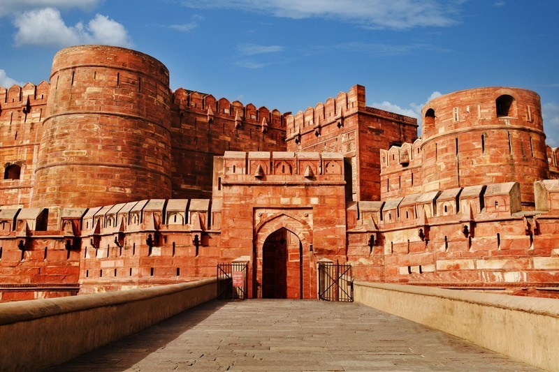
Rao Jodha (reign 1438–1489 CE) consolidated Marwar after a protracted conflict with Rana Kumbha of Mewar. In 1459 CE, Jodha shifted the capital from Mandore to a more defensible location, laying the foundation of Jodhpur. He commissioned the construction of the Mehrangarh Fort on the isolated cliff known as Bhakurcheeria, creating an impregnable administrative nucleus that successfully centralized the western desert core.
Rao Maldeo: The Period of Hegemony
Rao Maldeo (reign 1531–1562 CE) marked the absolute zenith of independent Rathore military power. Known by contemporary Persian chroniclers as the Hindustan ka Sabse Ba-Akhtiyar Raja (The Most Powerful Ruler in India), Maldeo pursued an aggressive multi-front expansionist policy. He annexed 52 districts, extending Marwar’s boundaries to touch the frontiers of Delhi, Sindh, and Gujarat. His expansionism triggered the decisive Battle of Sammel (Giri-Sammel, 1544 CE) against Sher Shah Suri, where the Afghan emperor narrowly escaped defeat.
Chandrasen Rathore: The Insurgent Resistance
Rao Chandrasen (reign 1562–1581 CE), often called the “Forgotten Hero of Marwar” or the “Pratap of Marwar,” led a fierce resistance against Mughal Emperor Akbar. After refusing to submit at the Nagaur Durbar of 1570 CE, Chandrasen abandoned Jodhpur and operated from the rugged hills of Bhadrajun and Siwana, pioneering high-altitude desert guerrilla warfare before Maharana Pratap adopted it in Mewar.
Raja Jaswant Singh I and the Imperial Crisis
Raja Jaswant Singh I (reign 1538–1678 CE) served as a premier Mughal noble (Mansabdar) under Shah Jahan and Aurangzeb, governing volatile frontiers like Kabul and the Deccan. His death in 1678 CE triggered a massive 30-year Rathore war of independence led by Durgadas Rathore against Aurangzeb’s attempts to annex Marwar into direct crown control (Khalsa).
| Sovereign | Major Engagements | Territorial Focus / Frontier Impact | Key Geopolitical Outcome |
| Rao Siha | Local skirmishes (c. 1243 CE) | Pali and Luni River Basin | Established the initial Rathore political footprint in western Rajasthan. |
| Rao Chunda | Annexation of Mandore (c. 1395 CE) | Eastern Plains Interface | Shifted capital to Mandore; institutionalized the Rathore clan-state framework. |
| Rao Jodha | Aonla-Chawla Sandhi (c. 1453 CE) | Mewar-Marwar Frontier | Founded Jodhpur and Mehrangarh Fort; stabilized boundaries with Mewar. |
| Rao Maldeo | Battle of Giri-Sammel (1544 CE) | Northern Frontier against Sur Empire | Extended Marwar across 52 districts; forced Sher Shah Suri to deploy his entire army. |
| Rao Chandrasen | Siege of Siwana (1574 CE) | Western Desert Insurgency | Rejected Mughal suzerainty; maintained independent guerrilla warfare. |
| Raja Jaswant Singh I | Battle of Dharmat (1658 CE) | Central / Succession Wars of Delhi | Commanded imperial forces; his death led to the 30-year Rathore War of Independence. |
Administrative Infrastructure and Resource Mobilization
The Bhai-Bant Feudal System
Marwar’s administration was based on the Bhai-Bant (brotherhood sharing) system, a unique segmentary clan-monarchy framework. The kingdom was not considered the absolute property of the king; instead, it was viewed as the collective territory of the ruling Rathore clan. The state was divided into crown lands (Khalsa) managed directly by the sovereign, and Patta lands (fiefs) assigned to clan members (Thakurs) in exchange for military service (Chakri) and seasonal financial contributions.
Specialized Administrative Hierarchy
The central government in Jodhpur operated through a highly stratified bureaucratic network to manage its extensive territories:
- Pradhan: The highest administrative and military official next to the Maharaja, traditionally chosen from elite noble families like the Kumpawats or Jaitawats.
- Diwan: The chief fiscal officer responsible for the collection of land revenue, treasury management, and monitoring rural agricultural assessments.
- Bakshi: The military paymaster who monitored the muster rolls of the feudal cavalry and maintained readiness standards at frontier outposts.
- Hakim: The administrative governor of a Pargana (district) who held civil, judicial, and tax-collection authority within his regional jurisdiction.
Fiscal Framework and Trade Economics
The financial sustainability of the state relied on agricultural extractions, pastoral taxes, and transit customs:
- Bhog: The primary agricultural tax levied on harvested crops, varying from one-third to one-half of the yield based on land classification (such as Chahi for well-irrigated land and Barani for rain-fed land).
- Ghasmori: A specialized pastoral tax levied on nomadic and semi-nomadic herders based on the size of their cattle and sheep herds.
- Mapa and Dani: Transit duties and customs tolls collected at commercial desert checkpoints from Banjaras (merchant caravans) operating trade routes between the ports of Gujarat and the urban centers of northern India.
Socio-Religious Governance and Cultural Synthesis
The Cult of Nagnechiya Maa
The Rathore rulers derived their spiritual legitimacy from the worship of Nagnechiya Maa, the ancestral clan deity (Kuldevi) of the dynasty. Rao Dhuhad in the early 14th century brought the wood-carved idol of the goddess from Karnataka and installed it at Nagana village in Barmer. The multi-armed deity, often associated with a serpent guardian form, served as a powerful ideological symbol that unified the diverse sub-clans under a single sovereign identity.
The Khyat and Literature Traditions
Marwar patronized a rich tradition of historical record-keeping and vernacular literature, breaking away from exclusive reliance on Sanskrit epigraphs:
- Khyats: Meticulous, prose-based historical chronicles detailing genealogies, battles, and administrative decisions. Muhnot Nainsi, the Diwan of Maharaja Jaswant Singh I, compiled the Muhnot Nainsi ri Khyat and the Marwar ra Pargana ri Vigat. The latter acts as a comprehensive medieval gazetteer, providing detailed statistical data on populations, castes, crop yields, and revenue systems of every district in Marwar.
- Bardic Poetry: Patronized Charan and Bhat scholars who composed heroic epics in Dingal (an archaic literary form of Rajasthani), preserving historical accounts of frontier defense.
Monumental Architecture and Desert Engineering
Rathore governance led to architectural styles tailored to survive the harsh desert climate:
- Mehrangarh Fort: Built on a perpendicular cliff, it features thick stone walls, highly decorated palaces with sandstone lattice screens (Jalis), and deep structural water reservoirs like the Ranisar and Padamsar tanks.
- Stepwell Engineering: The state commissioned extensive stepwells (Baoris), such as the Toorji ka Jhalra in Jodhpur, to secure the city’s water supply during prolonged military blockades or droughts.
High-Yield Facts and Trivia for UPSC Prelims
The Aonla-Chawla Sandhi (c. 1453 CE)
This boundary treaty permanently settled the territorial feud between Marwar (Rao Jodha) and Mewar (Rana Kumbha). Brokered by Hansa Bai, it fixed the physical border at the geographic transition zone where the Aonla (myrobalan) trees of the fertile Mewar plains met the Chawla (desert bushes) of the Marwar territory.
The Famous Quote on Giri-Sammel
Following the Battle of Giri-Sammel in 1544 CE, where the Rathore generals Jaita and Kumpa led a small contingent that nearly destroyed the central Afghan army, Sher Shah Suri famously stated in relief: “For a handful of bajra (pearl millet), I had almost lost the empire of Hindustan.”
The Creation of the Bikaner Branch
In 1465 CE, Rao Bika, the disgruntled eldest son of Rao Jodha, chose to abandon Jodhpur to avoid an internal succession war. He marched north into the wild Jangladesh region and established a separate sovereign Rathore state, founding Bikaner in 1488 CE and constructing the Junagarh fortification network.
The Kharda or Census Registers
Long before modern statistical surveys, the administrative network of Marwar utilized Khardas—detailed house-to-house census sheets that recorded the occupation, family size, livestock ownership, and tax eligibility of every rural household, showcasing advanced administrative planning.
Durgadas Rathore and the Save of Ajit Singh
Durgadas Rathore is celebrated in medieval historiography for rescuing the infant prince Ajit Singh from Aurangzeb’s captivity in Delhi in 1679 CE. He disguised the prince, smuggled him into the safety of the western Aravalli hills, and sustained a multi-decade national insurgency that eventually forced the Mughals to restore the throne of Jodhpur to the Rathore line.
Last Modified: June 22, 2026