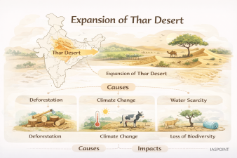
The Thar Desert, also known as the Great Indian Desert, is the world’s most densely populated arid region. Spanning approximately 200,000 km2, it primarily occupies western Rajasthan, with extensions into Gujarat, Punjab, Haryana, and Pakistan. Recent ecological assessments indicate that the desert is expanding toward the east and northeast, a process known as desertification, which threatens the fertile lands of the Indo-Gangetic plains.
Drivers of Desertification in the Thar Region
The expansion is not merely a natural phenomenon but is accelerated by a combination of climatic shifts and human interventions.
- Degradation of the Aravalli Range: The Aravallis act as a natural “green wall” preventing the eastward drift of sand. Excessive illegal mining and deforestation have created gaps in this range, allowing sand-laden winds to bypass the hills.
- Wind Erosion and Sand Drift: Strong south-westerly winds during summer transport loose sand to adjacent districts like Jaipur, Alwar, and the National Capital Region (NCR).
- Anthropogenic Pressures: Overgrazing by livestock, unscientific agricultural practices, and the depletion of groundwater have reduced the vegetative “anchor” that holds the soil.
- Climate Change: Shifting rainfall patterns and increased frequency of extreme heatwaves have exacerbated soil aridity, making land more susceptible to wind erosion.
Status of Land Degradation (ISRO Data)
According to the Desertification and Land Degradation Atlas of India (2021) published by the Space Applications Centre (SAC), ISRO:
| Category | Finding/Fact |
| Total Degraded Area | Approx. 97.85 million hectares (29.7% of India’s TGA). |
| Primary Driver | Water erosion is the top cause nationally, but Wind erosion is the leading cause in Rajasthan. |
| Statewise Impact | Rajasthan accounts for the highest area under desertification in India. |
| Recent Trend | While some areas show “greening” due to the Indira Gandhi Canal, surrounding fringe areas show high vulnerability to sand ingress. |
Impact on Surroundings and Climate
The expansion of the Thar Desert has far-reaching consequences beyond its geographical borders.
- Dust Storms in NCR: Increased sand drift contributes to the intensity of “Andhi” (dust storms) in Delhi and Haryana, significantly deteriorating air quality (PM10 levels).
- Altered Micro-climate: The expansion of arid surfaces increases the Albedo effect (reflectivity of the earth’s surface), which can disrupt local convection and rainfall patterns.
- Loss of Arable Land: The transition of semi-arid regions into arid zones reduces crop yields in the “granary of India” (Punjab and Haryana).
Mitigation and Government Initiatives
To check the expansion, the Indian government has initiated several large-scale ecological projects.
- The Green Wall of India: A planned 1,400 km long and 5 km wide green belt of trees extending from Gujarat to the Delhi-Haryana border, inspired by Africa’s Great Green Wall.
- CAZRI (Central Arid Zone Research Institute): Based in Jodhpur, this institute leads research on sand dune stabilization, shelterbelt plantations, and arid-land forestry.
- Desert Development Programme (DDP): Launched to minimize the adverse effects of drought and rejuvenate the natural resource base of the identified desert areas.
- National Action Programme to Combat Desertification: India is a signatory to the United Nations Convention to Combat Desertification (UNCCD) and aims to achieve Land Degradation Neutrality (LDN) by 2030.
Technical Trivia for UPSC Prelims
- Marusthali vs. Bagar: The proper desert with shifting sand dunes is called Marusthali, while the semi-desert sandy plain to the east of the dunes is known as Bagar.
- Dhrians: The local name for shifting sand dunes in the Thar Desert.
- Thar’s Fossil Record: The Akal Wood Fossil Park near Jaisalmer contains evidence that this region was once a lush forest under the sea during the Jurassic period.
- Luni River: The only major integrated river system in the desert; it is endorheic (does not reach the sea) and turns saline in its lower reaches.