
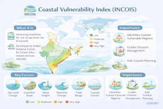
The Coastal Vulnerability Index (CVI) is a scientific tool developed by the Indian National Centre for Ocean Information Services (INCOIS), Hyderabad, under the Ministry of Earth Sciences. It quantifies the relative risk that physical changes will occur across the Indian coastline due to sea-level rise and other coastal hazards.
Core Concept and Purpose
The CVI provides a comparative ranking of various coastal segments based on their susceptibility to physical changes.
- Scale of Mapping: INCOIS has prepared a comprehensive Coastal Vulnerability Atlas of India comprising 156 maps at a scale of 1:1,00,000.
- Objective: To identify “stresses” on the coastline and assist disaster management authorities in prioritizing evacuation, coastal protection, and resilient infrastructure planning.
Physical and Geological Parameters
The index is calculated by integrating seven key parameters that influence coastal stability and inundation risk:
| Parameter | Impact on Vulnerability |
| Shoreline Change Rate | High erosion rates significantly increase vulnerability. |
| Coastal Geomorphology | Rocky coasts are less vulnerable; muddy/deltaic coasts are highly susceptible. |
| Coastal Slope | Gentler slopes allow water to penetrate further inland, increasing risk. |
| Coastal Elevation | Low-lying areas are prone to submergence and storm surges. |
| Relative Sea-level Rise | Historical and projected rates of local sea-level changes. |
| Mean Tidal Range | Areas with small tidal ranges are more vulnerable to sudden inundation. |
| Significant Wave Height | Higher wave energy leads to greater erosional force on the shore. |
Multi-Hazard Vulnerability Mapping (MHVM)
While CVI focuses on physical parameters, INCOIS also conducts Multi-Hazard Vulnerability Mapping (MHVM) at a finer scale of 1:25,000.
- Composite Risk: It overlays multiple hazards like sea-level rise, shoreline erosion, and extreme water levels (from storm surges and tsunamis).
- Data Input: Utilizes high-resolution topography and extreme water level return periods to delineate the Hazard Line.
- 2025-26 Update: Latest reports (e.g., ESSO-INCOIS-OMDA-TR-04(2025)) have integrated climate change projections to identify areas at risk of becoming “climate refugees” due to permanent inundation.
Findings and State-wise Vulnerability
Based on INCOIS assessments, different states exhibit varying degrees of risk:
- Gujarat: Has the largest share of coastline identified as vulnerable in absolute kilometers, though its percentage impact is moderate (~5.3%).
- West Bengal & Odisha: Exhibit high vulnerability due to low elevation and frequent cyclonic storm surges.
- Tamil Nadu: The Coromandel coast is highly susceptible to both erosion and wave-induced flooding.
- Islands: Lakshadweep and the Andaman & Nicobar Islands face a “Very High” ranking in specific segments due to limited elevation and direct exposure to oceanic swells.
Strategic Significance for UPSC
- Disaster Management: The CVI is a critical component of the National Disaster Management Plan (NDMP) for coastal states.
- CRZ Integration: The “Hazard Line” identified by CVI and MHVM is integrated into the Coastal Zone Management Plans (CZMPs) under the CRZ Notification, 2019.
- Blue Economy: Sustainable development of ports and maritime trade depends on the vulnerability assessments provided by INCOIS to ensure long-term structural viability.
Quick Revision Trivia
- Nodal Agency: INCOIS (Hyderabad), an autonomous body under the Ministry of Earth Sciences (MoES).
- Scale: 1:1,00,000 (Atlas) and 1:25,000 (Multi-hazard mapping).
- Formula Principle: The CVI is often calculated as the square root of the product of ranked variables divided by the number of variables, categorizing areas into “Low,” “Moderate,” “High,” and “Very High” risk zones.
- Related Service: INCOIS also operates the Tsunami Early Warning Centre and the Ocean State Forecast (OSF) services.