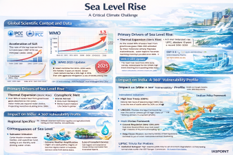
The phenomenon of Sea Level Rise (SLR) is a critical climate-driven challenge characterized by the increasing volume of the world’s oceans. According to the WMO State of the Global Climate 2025 report, global mean sea levels are rising at an accelerated pace, posing an existential threat to coastal ecosystems and nearly 1 billion people globally.
Global Scientific Context and Data
The Intergovernmental Panel on Climate Change (IPCC) and the World Meteorological Organization (WMO) provide the foundational data for monitoring SLR.
- Acceleration of SLR: The rate of rise has increased from 1.3 mm/year (1901–1971) to 3.7 mm/year (2006–2018).
- WMO 2025 Update: The report confirms that 2015–2025 were the hottest 11 years on record. Ocean heat content reached a new high in 2025, with the rate of warming more than doubling since 2005.
- IPCC AR6 Projections: Under high-emission scenarios (SSP5-8.5), global sea levels could rise by up to 1 meter by 2100. Even with aggressive mitigation, a rise of 0.3–0.6 meters is likely locked in.
Primary Drivers of Sea Level Rise
SLR is driven by two main physical processes, both linked to anthropogenic global warming.
- Thermal Expansion (Steric Rise): As the ocean absorbs over 90% of excess heat from greenhouse gases, water molecules expand, increasing the total volume.
- Cryospheric Melt (Eustatic Rise): * Glacial Retreat: Melting of mountain glaciers (e.g., Hindu Kush Himalayas).
- Ice Sheet Mass Loss: Accelerated melting of the Greenland and Antarctic ice sheets.
- Land Subsidence: Localized sinking of land due to groundwater extraction or tectonic shifts (e.g., Jakarta, Mumbai), which exacerbates the “relative” sea level rise.
Impact on India: A 360° Vulnerability Profile
India has a coastline of 7,516.6 km, encompassing 9 states and 4 Union Territories. The Indian National Centre for Ocean Information Services (INCOIS) has developed a Coastal Vulnerability Index (CVI) to map these risks.
Vulnerability of Major Indian Cities (Projected Rise by 2100)
| City | Projected Rise (Feet) | Key Threat |
| Bhavnagar | 2.70 | Highest projected rise; industrial risk. |
| Cochin | 2.32 | Backwater flooding; tourism impact. |
| Mumbai | 1.90 | Sinking at 2mm/year; high population density. |
| Chennai | 1.87 | Severe shoreline erosion. |
| Visakhapatnam | 1.77 | Critical port infrastructure risk. |
Regional Specifics
- Sundarbans (West Bengal): A UNESCO World Heritage site facing rapid land loss, salinization of soil, and displacement of “ecological refugees.”
- Arabian Sea vs. Bay of Bengal: The Bay of Bengal experiences higher inter-annual fluctuations and more intense storm surges, making the eastern coast more vulnerable than the western coast.
- The Himalayan Factor: Melting of Himalayan glaciers impacts the Indus, Ganga, and Brahmaputra basins, initially increasing river discharge (causing floods) followed by long-term water scarcity.
Consequences of Sea Level Rise
The impacts of SLR extend beyond simple inundation, affecting socio-economic and ecological security.
- Saltwater Intrusion: Contamination of freshwater aquifers and agricultural land, leading to “soil infertility” and drinking water crises.
- Extreme Weather Amplification: Higher sea levels provide a “higher base” for storm surges, making tropical cyclones significantly more destructive.
- Loss of Ecosystem Services: Submergence of mangroves (carbon sinks) and coral reefs (biodiversity hotspots).
- Economic Loss: Annual global costs to protect or relocate infrastructure could reach $14 trillion by 2100.
Global and National Response Mechanisms
International Initiatives
- High Seas Treaty (BBNJ): Entered into force in January 2026; aims to protect 30% of the world’s oceans by 2030 (30×30 target).
- UNCLOS: Provides the legal framework for maritime zones; addressing the legal status of “sinking nations” is a current priority.
- Blue COP: COPs under the UNFCCC are increasingly focusing on “Ocean-Climate Action.”
Indian Policy Framework
- Coastal Regulation Zone (CRZ) 2019: Regulates developmental activities based on the High Tide Line (HTL) and vulnerability.
- Multi-Hazard Vulnerability Mapping (MHVM): Conducted by INCOIS to identify areas at risk of inundation.
- Deep Ocean Mission: Launched by the Ministry of Earth Sciences for sustainable use of ocean resources and climate monitoring.
UPSC Trivia for Prelims
- Ecological Refugees: Term used for populations displaced due to environmental degradation, currently lacking formal status under the 1951 Refugee Convention.
- Zettajoules (ZJ): The unit used to measure Ocean Heat Content. In 2025, the rate of warming was approximately 11–12 ZJ per year.
- Isostatic Rebound: The rise of land masses after the removal of ice sheets (opposite of subsidence), affecting relative sea levels in polar regions.
- INCOIS Location: Headquartered in Hyderabad, it is an autonomous body under the Ministry of Earth Sciences.