With a coastline stretching over 7,516 km across nine states and four Union Territories, India is highly vulnerable to coastal hazards. Coastal adaptation involves adjusting ecological, social, and economic systems to mitigate the impacts of sea-level rise, cyclonic storms, and coastal erosion.
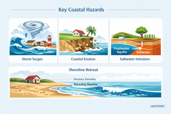
Key Coastal Hazards and Drivers
The Indian coastline is subject to both sudden-onset and slow-onset disasters driven by climate change and anthropogenic factors:
- Storm Surges: Abnormal rise in sea level during cyclones; the low bathymetry of the Bay of Bengal makes the East Coast particularly susceptible.
- Coastal Erosion: Approximately 33% of India’s coastline is under varying degrees of erosion.
- Saltwater Intrusion: Rising sea levels push saline water into freshwater aquifers, ruining agricultural land and drinking water sources.
- Shoreline Retreat: The landward migration of the high-tide line, threatening coastal infrastructure and settlements.
Structural and Non-Structural Adaptation Measures
Adaptation strategies are generally categorized into three engineering and policy approaches:
1. Hard Engineering (Structural)
- Seawalls and Bulkheads: Vertical structures designed to prevent inland flooding and resist wave action.
- Groynes and Jetties: Structures built perpendicular to the shore to trap sediments and limit longshore drift.
- Breakwaters: Offshore structures that reduce the intensity of wave action before it reaches the shore.
2. Soft Engineering (Nature-based Solutions)
- Bio-Shields: Planting mangroves, casuarina trees, and palm shelters to act as natural windbreaks and wave dissipators.
- Beach Nourishment: The mechanical placement of sand on eroding shores to advance the shoreline.
- Dune Stabilization: Using vegetation or fences to anchor sand dunes, which act as the first line of defense against surges.
3. Managed Retreat and Planning
- Coastal Regulation Zone (CRZ) Notifications: Regulatory frameworks that restrict construction within specific distances from the High Tide Line (HTL).
- Setback Lines: Demarcating “No Development Zones” based on predicted sea-level rise and erosion rates over 50-100 years.
Institutional and Policy Framework for Coastal Defense
| Initiative/Policy | Focus Area | Key Features |
| CRZ Notification 2018 | Land Use Regulation | Divides coastal areas into CRZ-I (Ecologically Sensitive), II (Developed), III (Rural), and IV (Water area). |
| Integrated Coastal Zone Management (ICZM) | Holistic Management | Promotes coordination between various sectors to ensure sustainable coastal development. |
| Encore Project | World Bank Funded | Enhances coastal resilience through better mapping and community-based institutional strengthening. |
| MISHTI Scheme | Mangrove Restoration | “Mangrove Initiative for Shoreline Habitats & Tangible Incomes” aimed at intensive afforestation along the coastline. |
Regional Vulnerability Profile
- East Coast (Bay of Bengal): High vulnerability to frequent, intense cyclones and heavy siltation from Himalayan rivers. Odisha and Andhra Pradesh are lead states in cyclone-resilient infrastructure (e.g., Multi-purpose Cyclone Shelters).
- West Coast (Arabian Sea): Historically less prone to cyclones but experiencing a rise in frequency. Characterized by rocky cliffs and pocket beaches; faces significant erosion in Kerala and Karnataka.
- Island Territories: Lakshadweep and Andaman & Nicobar face the highest risk from sea-level rise due to low elevation and sensitive coral reef ecosystems.
Technology and Early Warning Systems (EWS)
India utilizes advanced geospatial and satellite technology for coastal monitoring:
- INCOIS (Indian National Centre for Ocean Information Services): The nodal agency for providing Tsunami warnings and Ocean State Forecasts (OSF).
- Decision Support System (DSS): Uses numerical models to predict the extent of inundation during storm surges.
- Wave Rider Buoys: A network of sensors that provide real-time data on wave height, direction, and sea surface temperature.
Coastal Adaptation Trivia
- The “Blue Flag” Certification: An international eco-label given to beaches that meet high environmental and safety standards; India currently has 12 such beaches, promoting sustainable coastal tourism.
- Shelterbelts: India’s “Green Wall” along the coast consists primarily of Casuarina equisetifolia, which can reduce wind speed by up to 30%.
- Nodal Ministry: The Ministry of Earth Sciences (MoES) handles oceanographic monitoring, while the Ministry of Environment, Forest and Climate Change (MoEFCC) oversees CRZ regulations.